


Howdy, Friends and Readers, thanks for your patience with me, the wayward weather blogger.
Gee, I haven't posted here for almost TWO months! What kind of a blogger am I anyway?
Sporadic, I guess. Well, this morning I woke up with a newfound idea--to start a blog with a genuine new title that would not restrict me to a seasonal perspective. In hindsight, it was foolish to title a blog for a single season.
However, we now have a brand new blog for ALL seasons: http://geekweather.blogspot.com
The internal title of the blog is: "We speak weather." I never could learn Spanish but I do pretty good with weather! Anyway, it will be awhile before I get all the various bells & whistles functional. Bear with me, I promise I will saddle up some weather soon.
Thanks & Cheers, jp
August 11, 2009
June 13, 2009
Water, water everywhere

Well, Blog Fans, we've been getting a lot of water falling down out of the sky. The rain just keeps on coming. Here are the Idaho Falls precipitation statistics as of June 12:
PRECIPITATION (IN)
YESTERDAY 0.21 0.04 0.17 0.01
MONTH TO DATE 2.62 0.52 2.10 0.12
SINCE OCT 1 9.04 8.31 0.73 7.15
SINCE JAN 1 6.41 5.64 0.77 3.83
Looks like the formatting got lost on the above numbers. The first number is self-explanatory. The second number is "normal" for that time period. The 3rd number in each line is "departure from normal" and the 4th number is the total last year for each time period.
Since January 1st, you will note that we are over 50% higher than last year's precip rec'd to date. Pretty amazing to have over 2.5 inches in a mere 13 days. WOW!
Meanwhile, the Snake River reservoirs are basically plumped up. Rumor has it there's more water in them than there has been in the last 20 years. I have no way of confirming that rumor. The best way to watch the reservoir levels is with what's called a "teacup" diagram. Click here to see it.
June 8, 2009
Whazzup with this blog?
Greetings, loyal readers! I had NO idea this blog would have such an "after life." I just checked the statistics for the first time in weeks. The numbers were shocking. There were 45 visits to the blog in the week ending May 31 with 97 pages views!
Now get this:
As the blog header notes, we started this effort in early November 2008. We installed a Site Meter on February 14. Since mid-February, this blog has recorded an incredible 1,791 visits and 3,421 pages views! Shocking? You betcha.
What does this mean? Well, for starters, it means I really ought to consider bringing this blog back to life. I can't really change the address of the blog--it's fixed as the "winter0809" address. That was pretty shortsighted of me to give it such a narrowly focused name. However, I can indeed change the "working" title of the blog to something other than "The Great Winter..."
Our weather obviously continues to be very weird and I'm betting it's Mt. Redoubt's Legacy. Sooo...I am temporarily going to begin posting to this blog once again. I hope to be able to run a poll to get your opinions as to whether I should continue to post or simply leave the blog alive as a place to visit all the links at left.
Thank You for visting and ya'll come back!
(Note: After writ5ing the above, I added a simple poll, as you can see at left. It's actually a Twitter app. but it works great with blogs, too. Please give it a shot.)
April 17, 2009
Reaping Rewards of Righteous Winter!

Well, I can't help it--I have to include a photo from last year's bicycle trip to The Tetons, as well as a link to a few other photos. This is why we root and cheer for Epic Winters! We get a huge snowpack and we get to enjoy it in SOOOO many different ways. Snowshoeing in the winter (and spring) bicycling in the Tetons with snow piled high beside the roads, watching huge river runoff, camping in verdant meadows, ah, the list goes on. Click here to see the few other Teton photos we were able to find tonight.
The Seam!

WOW--Look at this clip from the global water vapor view! Totally awesome, is all we can say! Susun and I are heading out tomorrow for Jackson and Moose, Wyoming (AKA--The Grand Teton National Park). We've booked a room in Jackson and we're planning on a righteous two days of bicycle riding on...where else?...the Grand Teton Road!
One of the great perks of living in Idaho Falls is this: In April, the National Park Service opens the Grand Teton Road to ALL non-motorized traffic. This includes not only bicycles but also people pushing baby strollers, roller bladers, walkers, hikers, kids on their BMX bikes, you name it, it's there. Last year when we did this road on April 28 is was like a religious experience. EVERYBODY was there! Young, old and in between. The hip and fit, the old and slow, nobody cared about how they looked or how cool they were. They were just THERE and that was all that mattered. I will never forget the two Mom's who had skated their twin strollers all the way to the Jenny Lake parking lot and then plopped themselves down right in the middle of the asphalt for a picnic. NO WORRY--NO CARS! They were so happy and their babies were frolicking with no fear. It was awesome and truly unforgettable.
Well, check out the water vapor snippet--we've caught a seam in the weather. WHAA--WHOOO! This is rich stuff and it's real stuff. The temps are expected to rise almost to 60 degrees up there on the east front of the Teton Range. And, get this--NO WIND!
Yeah, we're jazzed and pumped and all those iconic words. We even bought a motel room in Jackson so we can go both days this weekend. And we even spent all day Friday "rigging" for the trip. This is really cool stuff. I hope to come back to the blog and place in a link of last year's photos. Yippie, skippie, we're stoked!
April 7, 2009
Sulphur Gas Cloud

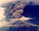
Leave it to Spaceweather once again. If you go to their website tonight, you can see an animation of a 600-mile diameter sulfur gas cloud forming off California! WHOA, Nellie, this is real and this is true! This is Mt. Redoubt in action! It's awesome!
The old adage "stay tuned" seem SO tame with Mt. Redoubt. Redoubt is awesome. It's going to change global weather and maybe even the global economy. It's huge & amazing!
April 4, 2009
Redoubt Stuff
 Well, Spaceweather once again "takes the cake" for the most educational and entertaining coverage of the Mt. Redoubt eruption saga. Today, there is a link to a truly great article from the folks at NASA. If that isn't enough, the NASA article links off to an incredible website maintained by somebody with WAAAAAY too much time on their hands. Luckily, their scientific mindset combines with the available time to create a "can't miss" website. You've just go to go there to check it out. I guess the explosion tally is now at 19 and counting. Redoubt is showing no signs of letting up.
Meanwhile, as you all know, the weather in the Lower 48 continues to amaze. If anything, it's getting weirder and wilder rather than tamer. A casual glance out into the crystal ball of the Pacific shows more great gobs of water vapor heading our way. The jetstream is freaked out and flipping every which way but zonal.
A very interesting sea surface temperature pattern is evolving, too. Gee, now along comes Polly Redoubt, too. What's next? A landing of Happy Aliens dropping out of the Huge Spaceship shown above? No, that's not a spaceship--it's lightning in a cloud above Redoubt at night! That volcano is putting on quite a show and, thankfully, someone is paying attention and getting us some awesome photography, too!
April 1, 2009
Leave it to Spaceweather!

Hi, it's April Fool but this is NOT an April Fool post here. I came onboard to post up about the West Pacific water vapor patterns. While I was on the blog site I decided to look around at the link and so forth. I visited Spaceweather. And wouldn't you know it--they are the ones who finally have a map of the sulphur gas dispersal from Redoubt. They couldn't care less about weather impacts, they are only looking for spectacular sunsets. Whatever. Visit Spaceweather for some awesome reporting on both ash and gas. In the above GIF-clip, it's the red pixels that are sulphur gas. I tried to copy their animated GIF of this gig but I couldn't. You will have to visit Spaceweather to find it. Good luck--it really shows what's happening as redoubt huffs and puffs and spits earth guts into the sky. This is cool stuff! (Like, REALLY!)
Check the West Pacific Water vapor!

WOW, Sports Fans, this is pretty impressive--it's a stacked deck heading east--ain't no way it's gonna miss the You Ess of Eh! I'm thinking the legacy of those volcanoes is really starting to pay some "add on" dividends now. When the Redoubt deposit kicks in, it sure could be a wet and cold summer season. Forest Fires? Fuggetaboutit!
March 23, 2009
BAM--Redoubt Blows
Woke up to the news today, oh boy! Plume to 50,000 feet from four explosions overnight. How about this quote from one of the scientists? "There's going to be a very fine amount of it that's going to be suspended in the atmosphere for quite some time..." WOW!
Comments added March 29 at 8 pm MDT: It's been a wild ride for Redoubt so far! It's rather difficult to fgure out the actual number of eruptions as well as their duration and the extent of the cloud tops. Here's what I can glean from their website:
March 28--At least four explosions. Two tops at 45K and 50 K and two at 25K and 35K.
March 27--At least four explosions. Two tops at 50K and two tops at 40K
March 26--One really large, long duration explosion lasting more than an hour. Tops to 65K.
March 22-23--Four or five initial explosions, most tops to 50K some to 60K.
I think there's been at least 15 decent explosions with a few being really super decent. The Anchorage Airport was closed for awhile after a light dusting of volcanic ash. Alaska Airlines has supposedly scrubbed over 150 flights total since the activity began.
So far, I can't find any information on the composition, extent and dispersal of gas clouds. I'd guess that there has to be a lot of gas getting shot into the atmosphere but I really can't find any data to support my guess. Chances are Redoubt is going to continue its discharges. So far, it's been a pretty vigorous volcano.
One thing's for certain--this is not the proverbial "one shot deal." Nope, Redoubt is going about its business as a volcano and behaving quite well, actually. If it continues this behavior we're going to have some major climate changes in store for a long time to come. Our weather is already pretty danged weird. I suspect it's going to get a LOT weirder if Redoubt continues to huff and puff and blow ash and gas into the 50-60,000 portion of the atmosphere.
March 8, 2009
Your checklist
Greetings, Dear Readers! This will be our last Sunday School. We are preparing to put this blog to sleep as winter is mostly over and Spring has already sprung in some parts of America. We will have a few more posts but not very many and not very frequently. So, it's going to be up to you, yourselves and you to carry on whatever you may wish from this blog. Yes, we will leave it up and running. That means you can come back any time and use the convenient links at left. This morning, I arranged them in my personal order of priority. That's what we will be talking about today in Sunday School.
Most of you have been flying in a small private airplane. As you know, the pilot goes through a rigorous checklist before taking off. For pilots, this checklist becomes a way of life, a cultural practice and, quite literally, it is the difference between life and death. Failure to follow your pre-flight checklist can mean dire consequences!
Luckily, our checklist isn't on the same level of magnitude. However, I use the analogy to encourage you to develop a "way of thinking" about looking at weather. Try to tick off the element of your own personal checklist whenever you are pondering weather patterns and trends. Try to develop this practice as a personal habit. Put the weather through its paces, so to speak. Ask yourself the same questions and probe the seemingly easy answers for alternate scenarios. Weather happens. It always has and it always will. Whether it happens that we can understand how weather happens is entirely dependent on our "way of thinking" about weather. Although no one ever has or ever will be able to predict weather with guaranteed 100% accuracy, we believe that it is possible to form and craft reasonable "best guesses" that generally reflect prevailing climate trends.
Even if no one can predict the weather, we can all have fun discussing and pondering the weather--it is one common topic that all humans everywhere share. The tools we have been using here on this page will always stand you in good stead. They are the bread and butter tools of weather forecasters everywhere. As such, your use of these tools gives you one leg up on anyone else who simply relies on the "gossip of the day" to form their weather opinions.
I am sure you will find your own personal balance in use of these tools. What works for me probably won't work for you in exactly the same way. However, I suspect we will all wind up using the same tools, even if they are ranked and ordered in slightly different ways.
My "Weather Life" always begins and ends with the jetstream. As I've said before here, I eat, sleep, live and breathe the jetstream. Even if I am not writing about it on this blog, you can be sure it is the very first thing that I pay attention to. "Where is the jetstream?" is the top question that is and always will be riveted into my brain. I would suggest that you also adopt this mantra question "Where's the jet?" as your top-of-the-checklist item.
"Where's the water vapor?" is the next topic on my checklist. To me, the jetstream and the water vapor go hand-in-hand. They are like the sides of a coin--forever joined. I like to know what is happening to the water vapor all year every year. I have been watching the US Navy's water vapor maps since I discovered them way back in 1996. Susun and I even tried to visit the Monterrey Naval Research Lab in 2002 but we were turned away by machine gun toting guards. There are many depictions of water vapor available on the internet. I like the Navy's the best. It is like an old friend, someone I can trust, someone I know and someone who won't let me down in a pinch. So I dote on the jetstream and the water vapor. When we are traveling and have perhaps only a few minutes available on a public computer in some forgotten library in some dust-ball downtown, I go to the jetstream and the water vapor. They are my anchors and the foundation of everything I thinnk about when I think of weather patterns.
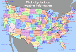
I have put the map of the NWS Office locations as the Number 3 link for a specific reason. It's because the AFD's are my "goto" source of weather perspectives. AFD, as you recall, means "Area Forecast Discussion." Each shift in each NWS office prepares at least one AFD each day.
By reading the various AFD's, I have the assembled knowledge of many lifetimes of forecaster wisdom at my fingertips. Here in Idaho Falls I read the Pocatello AFD at least twice each day. When storms approach, I broaden my horizon and read the neighboring NWS Office AFD's. When a really big event is taking shape, I might read the AFD's along the Pacific Coast or as far south as Phoenix and San Diego. To find any AFD in America, simply look at the little map at left and spy out the name of the NWS Office. Thes use this search string in your Google search field: "(__office name__) NWS AFD discussion." Nine times out of ten, this will bring up the correct link to get to the latest AFD for the office of your choice. The AFD's are your Best Friends in this business. Never leave home without them!
The next items are more or less equal--the NWS Composite warning map and the five-day QPF. The warning map shows what's happening right now. The QPF shows the expected precipitation for the up to five days. They give you a great "reality check" in formation of your opinions about the weather today and in the immediate future. I rely heavily on each of them and would be lost without them.
The next two links are also pretty much equal--surface temperatures and the national high & low map. These two links work great in combination together. There are at least a ba-zillion weather maps showing daily surface temps and the ebb and flow of highs and lows. I have picked these maps because they are clea, simple and colorful. Plus, you can see them without having to endure a blizzard of online advertising so common with the commercial weather websites.
The Model Animaiton Link is interesting but can be very misleading. Use it with caution. It certainly is fun to look at but, bear in mind, it's a model. If you read the AFD's as much as I do, you will know that every forecaster who has ever lived has been fooled often by the models. The model animation will give you a medium decent good perspective on how patterns "MIGHT" shape up in the 10 day forecast period. Use a little bit of "left english" and a few grains of salt whenever you click into the model animations.
The Climate Prediction Center is a great website. I've used it for probably as many years as it's been in existence. CPC give you the broad brush strokes of upcoming climate. As such it's a lot like a work of art--the beauty is in the eyes of the beholder. Keep the CPC graphics at arm's length to enjoy them the most. If you dwell too much on what the CPC has to say, you're almost certain to be disappointed. However, the CPC is a valuable tool when taken in conjunction with the other above tools at your disposal.
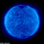
Spaceweather is our next link. Spaceweather is a highly entertaining website. I plan on looking at it every day from this point forward. Readers Gary W. (Lizard) suggested we use it for this blog. I was hooked immediately. Thanks, Gary! Space weather won't have the same immediate impact on our weather as a clod front sweeping ashore. However, as the upcoming sun spot cycle begins to take shape, you will begin to see some strong relationships between solar output and the behavior of the jetstream. Right now, the sun is as tame as a sleeping tiger in a zoo. But beware, when this next sun spot cycle gets rolling, it will be anything but sleeping! And the impacts on our earth weather could be profound. Keep an eye on space weather via Spaceweather--it's the best such website there is anywhere on the planet!
Most readers know how I feel about volcanoes. Heck, it three volcanoes in the Aleutians that prompted me to start this blog way back in November 2008. I first learned about the impact of volcanoes on our weather in 1977 when I read Iben Browning's "Climate and The Affairs of Man." One of my Loyal Readers and True Friends, Dave E. continues to send me the Browning Newsletter now published by Iben's daughter. If you don't realize how important volcanoes are to our planetary weather, then you need to go to reform school! Volcanoes are the single most important factor in shaping our weather over the long-term. Nothing else comes remotely close to their impact. Period. I put this link near the bottom not because it isn't important. I put it there because volcanoes don't erupt every day. They only erupt once in awhile. But their presence is ever-present and therefore you MUST pay attention to volcanoes. Visit the volcano website often. Keep an eye on their condition and what's happening around the globe. Looks at where their ash and gas goes in the atmosphere. Pay attention to what's downstream from their location. Make volcano watching a major part of your life form this day forward. Promise?
The Global SST's are very imporant, too. They don't lie. What you see is what you get. Yes, they change. But they don't change quickly. They "evolve." Watching the evolution of SST's is like watching a very slow waltz. It's enchanting and captivating. The key thing to watch for in the SST's is large areas of hot or cold water. The larger and the more extreme, the more impact it is likely to have on weather. If you have time and inclination, I suggest you become conversant in all of the alhabet soup phases of the oceans. The oceans are alive. They are not static bodies of water just sitting there. Oceans are doing stuff all the time. They are conducting "ocean business" and their business affects our business. Big time! The more you learn abou tthe oceans' impact on weather, the happier you will be. Trust me, time spent sutdying oceans is time well spent. However, if you have no time to spend studying oceans, at least watch the SST's--they are kind of like the financial reports of a business. Lots of activity had to happen for a business to be able to complile and file a financial report. Ditto with oceans--lots of "stuff" had to happen in the business of being an ocean for the SST's to rise or fall. You won't really know what went on behind the scenes but at least you get to see the "reports." Never forget to pay attention to SST's. The day you do is the day you will get blindsided!
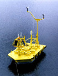
Below the SST link is the buoy link. This is a "reality check" link. When you see a big storm sweeping ashore, you can check its passport by going out to a buoy anchored in the line of fire. Buoys wil tell you if the sea is really getting its anatomy kicked. Sometimes, storms appear to be full of fury but when you check the buoy data, you will see it's all hype and tease. Buoys don't lie!
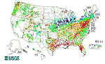
Finally, we come to the SNOTEL website and it's companion the USGS real time streamflow gateway. As you know, I refer often to the USGS data. However, I just added this link today for your convenience. Snow and water are the measurable output of storms. They are the "bottom line," so to speak. A storm can be all fuss and bluster but it might not really yield anything of substance. The SNOTEL and streamflow websites will tell you "the rest of the story," as the late Paul Harvey would say. Going to those websites reminds me of a guy I saw in the Customer Service line at a grocery store this week. You could look at the guy and know he had some low rent, minimum wage job. He was clutching his weekly paycheck and he was waiting in line to cash it. His clothes were dirty for a hard day's work and his hands showed the price he paid to hold that paycheck. I couldn't see the eact amount but I could spy it was a small check. I watch him smile when he looked at that check and I felt his pride in himself for a week's worth of hard work. The line was long and slow, so he had time to glance often as his check. Each time as he did, many thoughts flowed through my mind. I realized that's what we do when we look at the SNOTEL's and the streamflows. We're proud of our bottom line--we're proud we have these gifts from our weather--we're proud to have weathered our storms and we're danged happy we're standing in line to cash our check! We're looking for some good times tonight!
Well, there you have it. Don't spend it all in one place--save some for tomorrow, too. I wish you well in your study of our weather. I know this blog will be a great place to visit even if there are no regular posts spewing forth from the blog author. I'm certain that it will be useful to you for a long time to come. I've had a great time writing in during these last 120 days. yes, it started November 8 and today is March 8, 120 days to the whisker! Thanks for being my Loyal Readers. Have a great day and Happy Trails! Cheers from John P.
Most of you have been flying in a small private airplane. As you know, the pilot goes through a rigorous checklist before taking off. For pilots, this checklist becomes a way of life, a cultural practice and, quite literally, it is the difference between life and death. Failure to follow your pre-flight checklist can mean dire consequences!
Luckily, our checklist isn't on the same level of magnitude. However, I use the analogy to encourage you to develop a "way of thinking" about looking at weather. Try to tick off the element of your own personal checklist whenever you are pondering weather patterns and trends. Try to develop this practice as a personal habit. Put the weather through its paces, so to speak. Ask yourself the same questions and probe the seemingly easy answers for alternate scenarios. Weather happens. It always has and it always will. Whether it happens that we can understand how weather happens is entirely dependent on our "way of thinking" about weather. Although no one ever has or ever will be able to predict weather with guaranteed 100% accuracy, we believe that it is possible to form and craft reasonable "best guesses" that generally reflect prevailing climate trends.
Even if no one can predict the weather, we can all have fun discussing and pondering the weather--it is one common topic that all humans everywhere share. The tools we have been using here on this page will always stand you in good stead. They are the bread and butter tools of weather forecasters everywhere. As such, your use of these tools gives you one leg up on anyone else who simply relies on the "gossip of the day" to form their weather opinions.
I am sure you will find your own personal balance in use of these tools. What works for me probably won't work for you in exactly the same way. However, I suspect we will all wind up using the same tools, even if they are ranked and ordered in slightly different ways.
My "Weather Life" always begins and ends with the jetstream. As I've said before here, I eat, sleep, live and breathe the jetstream. Even if I am not writing about it on this blog, you can be sure it is the very first thing that I pay attention to. "Where is the jetstream?" is the top question that is and always will be riveted into my brain. I would suggest that you also adopt this mantra question "Where's the jet?" as your top-of-the-checklist item.
"Where's the water vapor?" is the next topic on my checklist. To me, the jetstream and the water vapor go hand-in-hand. They are like the sides of a coin--forever joined. I like to know what is happening to the water vapor all year every year. I have been watching the US Navy's water vapor maps since I discovered them way back in 1996. Susun and I even tried to visit the Monterrey Naval Research Lab in 2002 but we were turned away by machine gun toting guards. There are many depictions of water vapor available on the internet. I like the Navy's the best. It is like an old friend, someone I can trust, someone I know and someone who won't let me down in a pinch. So I dote on the jetstream and the water vapor. When we are traveling and have perhaps only a few minutes available on a public computer in some forgotten library in some dust-ball downtown, I go to the jetstream and the water vapor. They are my anchors and the foundation of everything I thinnk about when I think of weather patterns.
I have put the map of the NWS Office locations as the Number 3 link for a specific reason. It's because the AFD's are my "goto" source of weather perspectives. AFD, as you recall, means "Area Forecast Discussion." Each shift in each NWS office prepares at least one AFD each day.
By reading the various AFD's, I have the assembled knowledge of many lifetimes of forecaster wisdom at my fingertips. Here in Idaho Falls I read the Pocatello AFD at least twice each day. When storms approach, I broaden my horizon and read the neighboring NWS Office AFD's. When a really big event is taking shape, I might read the AFD's along the Pacific Coast or as far south as Phoenix and San Diego. To find any AFD in America, simply look at the little map at left and spy out the name of the NWS Office. Thes use this search string in your Google search field: "(__office name__) NWS AFD discussion." Nine times out of ten, this will bring up the correct link to get to the latest AFD for the office of your choice. The AFD's are your Best Friends in this business. Never leave home without them!
The next items are more or less equal--the NWS Composite warning map and the five-day QPF. The warning map shows what's happening right now. The QPF shows the expected precipitation for the up to five days. They give you a great "reality check" in formation of your opinions about the weather today and in the immediate future. I rely heavily on each of them and would be lost without them.
The next two links are also pretty much equal--surface temperatures and the national high & low map. These two links work great in combination together. There are at least a ba-zillion weather maps showing daily surface temps and the ebb and flow of highs and lows. I have picked these maps because they are clea, simple and colorful. Plus, you can see them without having to endure a blizzard of online advertising so common with the commercial weather websites.
The Model Animaiton Link is interesting but can be very misleading. Use it with caution. It certainly is fun to look at but, bear in mind, it's a model. If you read the AFD's as much as I do, you will know that every forecaster who has ever lived has been fooled often by the models. The model animation will give you a medium decent good perspective on how patterns "MIGHT" shape up in the 10 day forecast period. Use a little bit of "left english" and a few grains of salt whenever you click into the model animations.
The Climate Prediction Center is a great website. I've used it for probably as many years as it's been in existence. CPC give you the broad brush strokes of upcoming climate. As such it's a lot like a work of art--the beauty is in the eyes of the beholder. Keep the CPC graphics at arm's length to enjoy them the most. If you dwell too much on what the CPC has to say, you're almost certain to be disappointed. However, the CPC is a valuable tool when taken in conjunction with the other above tools at your disposal.
Spaceweather is our next link. Spaceweather is a highly entertaining website. I plan on looking at it every day from this point forward. Readers Gary W. (Lizard) suggested we use it for this blog. I was hooked immediately. Thanks, Gary! Space weather won't have the same immediate impact on our weather as a clod front sweeping ashore. However, as the upcoming sun spot cycle begins to take shape, you will begin to see some strong relationships between solar output and the behavior of the jetstream. Right now, the sun is as tame as a sleeping tiger in a zoo. But beware, when this next sun spot cycle gets rolling, it will be anything but sleeping! And the impacts on our earth weather could be profound. Keep an eye on space weather via Spaceweather--it's the best such website there is anywhere on the planet!
Most readers know how I feel about volcanoes. Heck, it three volcanoes in the Aleutians that prompted me to start this blog way back in November 2008. I first learned about the impact of volcanoes on our weather in 1977 when I read Iben Browning's "Climate and The Affairs of Man." One of my Loyal Readers and True Friends, Dave E. continues to send me the Browning Newsletter now published by Iben's daughter. If you don't realize how important volcanoes are to our planetary weather, then you need to go to reform school! Volcanoes are the single most important factor in shaping our weather over the long-term. Nothing else comes remotely close to their impact. Period. I put this link near the bottom not because it isn't important. I put it there because volcanoes don't erupt every day. They only erupt once in awhile. But their presence is ever-present and therefore you MUST pay attention to volcanoes. Visit the volcano website often. Keep an eye on their condition and what's happening around the globe. Looks at where their ash and gas goes in the atmosphere. Pay attention to what's downstream from their location. Make volcano watching a major part of your life form this day forward. Promise?
The Global SST's are very imporant, too. They don't lie. What you see is what you get. Yes, they change. But they don't change quickly. They "evolve." Watching the evolution of SST's is like watching a very slow waltz. It's enchanting and captivating. The key thing to watch for in the SST's is large areas of hot or cold water. The larger and the more extreme, the more impact it is likely to have on weather. If you have time and inclination, I suggest you become conversant in all of the alhabet soup phases of the oceans. The oceans are alive. They are not static bodies of water just sitting there. Oceans are doing stuff all the time. They are conducting "ocean business" and their business affects our business. Big time! The more you learn abou tthe oceans' impact on weather, the happier you will be. Trust me, time spent sutdying oceans is time well spent. However, if you have no time to spend studying oceans, at least watch the SST's--they are kind of like the financial reports of a business. Lots of activity had to happen for a business to be able to complile and file a financial report. Ditto with oceans--lots of "stuff" had to happen in the business of being an ocean for the SST's to rise or fall. You won't really know what went on behind the scenes but at least you get to see the "reports." Never forget to pay attention to SST's. The day you do is the day you will get blindsided!
Below the SST link is the buoy link. This is a "reality check" link. When you see a big storm sweeping ashore, you can check its passport by going out to a buoy anchored in the line of fire. Buoys wil tell you if the sea is really getting its anatomy kicked. Sometimes, storms appear to be full of fury but when you check the buoy data, you will see it's all hype and tease. Buoys don't lie!
Finally, we come to the SNOTEL website and it's companion the USGS real time streamflow gateway. As you know, I refer often to the USGS data. However, I just added this link today for your convenience. Snow and water are the measurable output of storms. They are the "bottom line," so to speak. A storm can be all fuss and bluster but it might not really yield anything of substance. The SNOTEL and streamflow websites will tell you "the rest of the story," as the late Paul Harvey would say. Going to those websites reminds me of a guy I saw in the Customer Service line at a grocery store this week. You could look at the guy and know he had some low rent, minimum wage job. He was clutching his weekly paycheck and he was waiting in line to cash it. His clothes were dirty for a hard day's work and his hands showed the price he paid to hold that paycheck. I couldn't see the eact amount but I could spy it was a small check. I watch him smile when he looked at that check and I felt his pride in himself for a week's worth of hard work. The line was long and slow, so he had time to glance often as his check. Each time as he did, many thoughts flowed through my mind. I realized that's what we do when we look at the SNOTEL's and the streamflows. We're proud of our bottom line--we're proud we have these gifts from our weather--we're proud to have weathered our storms and we're danged happy we're standing in line to cash our check! We're looking for some good times tonight!
Well, there you have it. Don't spend it all in one place--save some for tomorrow, too. I wish you well in your study of our weather. I know this blog will be a great place to visit even if there are no regular posts spewing forth from the blog author. I'm certain that it will be useful to you for a long time to come. I've had a great time writing in during these last 120 days. yes, it started November 8 and today is March 8, 120 days to the whisker! Thanks for being my Loyal Readers. Have a great day and Happy Trails! Cheers from John P.
March 7, 2009
The Saturday Shuffle
Greetings, Dear Readers! Only two more weeks until the first day of Spring! This particular post will be a grab bag of various topics--nothing really interesting or important to discuss this morning.
Tomorrow's Sunday School will be the same lesson planned last week. We want to do a review session for you. We will be winding down this blog very soon and we want to make sure that you are properly prepared in all of the tips and tricks for using the links at left to improvise your own weather prognostications. This blog will be going into hibernation on the Vernal Equinox--afterall, the blog is about WINTER--not SPRING!
While reviewing all of our links at left, I was intrigued by the massive area of warm surface temps in the midwest and east. Gee, wasn't it barely a week ago that they were shivering and getting pounded? Also, the QPF back there is pretty substantial. Things are pretty quiet on the Western Front. The far Pac NW is getting some action and perhaps the Idaho Panhandle, too. Otherwise, it's pretty bland.
The CPC people say that California will have above normal precip during the next 30 days. I'd reckon that's a reasonable guess judging from the persistent Pacific patterns prevailing out yonder.
Spaceweather is quite interesting today--check it out. There's an awesome photo of Saturn. Saturn is at perigee this weekend and also at opposition to the Sun. That's kind of a big deal in the astro circles. Actually, it might even be a big deal in the world financial circles, too, but that's another story beyond the scope of this blog. Whatever the case, be sure to check out the pretty pictures of Saturn on the Spaceweather website.
I roamed 'round the SNOTEL site looking at the percent-average of various California rivers. They sure look like they are in good shape, all things considered. Meanwhile, Arizona rivers and reservoirs are in REALLY good shape. Roosevelt Lake is 100% full and there's over 2000 cfs coming into the lake. That means it's spilling at least 2,000 cfs! Over in New Mexico most of the state is under a red flag warning. Oddly, the red flag warning ends at the Arizona line. I wonder how that works? Maybe the wind knows when it enters New Mexico that it's supposed to pick up the pace.
The Upper Snake River is in good shape and Jackson Lake should fill and spill this year. Tater Nation will be happy about that.
Well, that's about all there is to report weatherwise today. Tomorrow's discussion will be very generic in scope--just a review of how to use the tools we have assembled on this website. It's been a lot of fun writing this Winter 0809 blog. Maybe next year we will go it again. Who knows? Have a great day and GO PLAY!
March 5, 2009
Ah, HA! What were we saying?
Hey, Dear Readers, I have been taking a break from the Winter 0809 blog. Somehow, reality got real distorted over in California and I just decided to "chuck it" for a well-deserved break. It's Thursday night and so I decided to once again come back and "tune in" to my blog.
Lo and behold, I just found this snippet online:
"Heavy snowfall brought a dramatic increase to the Sierra snowpack, which has lagged significantly below average levels this season. As much snow as normally falls in the Tahoe-Truckee area during the entire month of March fell during its first three days, experts said.
On Wednesday, the Truckee River and Lake Tahoe Basin's snowpacks were measured at 87 percent of average for the date, up from 79 percent Tuesday morning and the lower 70s a week ago.
"I looked at those numbers two or three times this morning and just said, 'Wow,'" said Dan Greenlee, a hydrologist with the U.S. Natural Resource Conservation Service.
"It was a phenomenal storm," Greenlee said. "We still need some more, but it's definitely an improvement."
The storm dumped enough precipitation into Lake Tahoe in three days to raise its water level nearly 4 inches, increasing Tahoe's water storage by about 38,000 acre-feet, Greenlee said. That's more than 12 billion gallons."
Well, as you might expect, this type of stuff gets me pretty excited. I guess I was "right" afterall. Once that Muscle Bound Guy, Arni What's-His-Name, said they were in a statewide drought, well, I guess I kinda lost interest. Even though I knew it wasn't really "so," that type of political hype really just annoyed me enough to take a break from this weather blog. Afterall, I also write blogs about volunteers, food shopping and trading Zions Bank stock. I don't need to hang out here. So I took a break.
It's so nice to come back from my break and see that Lake Tahoe gained 12 billion gallons from the last storm. That really kind of validates things like the QPF graphics and the jetstream and the Navy water vapor maps and all of that other esoteric stuff we watch, doesn't it? Geeze!
Well, I am going to run along now--this was just a quick visit back to the Winter 0809 blog--we will add more insights tomorrow. In the meantime, I suggest readers of this blog enjoy a little moment of self-congratulations. We all saw this coming and we should be proud of ourselves. Thank you for your support.
March 3, 2009
Tuesday thoughts
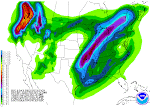
 Greetings, Dear Readers! I have posted the latest 5-day QPF forecast above. You can see that California once again is getting all the action. I clicked around through the NWS National Warning map graphic and I found this snippet: "THE STORM HAS THE POTENTIAL TO BRING TOTAL SNOW ACCUMULATIONS OF 2-3 FEET TO THE REGION...ESPECIALLY ABOVE THE 5500 FOOT ELEVATION." That's pretty cool language!
We've been having various varieties of rain in Idaho Falls today. It's been like a whole progression of all the types of rain. None of them have been hard rain--just different varieties. It's been fun. We've had rainbows, too. It was clear at lunch and Susun and I ate outside on the patio of a fancy restaurant. It felt hot. But then the weather changed later in the afternoon and it was too cold and windy to go feed the geese on the greenbelt near the Falls. Go figure!
By the way, if you haven't been over to Spaceweather.Com, you really ought to make a visit tonight. There's a Solar Prominence that's pretty dazzling right now. I won't bore you with the details. Just go visit Spaceweather's link in the left column and see for yourself. be sure to click through the various links--it's impressive!
The Snake River here went ice free at the Falls today. All the local tongues were wagging about it. People pay more attention sometimes that I tend to give them credit for. Now that I can see actual real open water I am trying to think of a way to pry our frozen canoe out of the glacier beside the garage and get it on the water. Wishful thinking, I suppose.
Well, there's lots of weather to enjoy, so ENJOY IT!
Gravity Wave? Who knew?
Perhaps you have been as intrigued as I have been by media coverage of The Big Winter Storm back east. As you might expect, I have been lapping up the various storm stories like a purring kitten in front of the warm bowl of milk.
This morning the headline in one of the stories immediately caught my bleary eyes: The Philadelphia Inquirer's headline blared: "Gravity Wave: powered late season snowstorm. Gravity Wave? Gee, I guess I have fallen behind in the Lingo Wars or somehow dropped off the Nomenclature Wagon or something. Gravity Waves? Huh?
Well, guess what? Gravity waves are totally real you can read all about them, too.First, click here for the Philly story. Naturally, I immediately went to Wikipedia in hopes that awesome online tome would have something about gravity waves.Sure enough, here is the Wiki entry on the phenomena.Once at Wiki you will find this really impressive piece of "math art" adorning the Wiki page. If this doesn't make you want to drink more coffee, I sure don't know what will! Who knew? (Click the graphic for a larger one.)

March 2, 2009
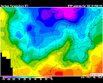
Quite the comparison!
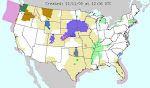
 I'm posting up the afternoon surface temp map. It's quite the comparison. If you look at the overnight temps below and then this map, you can clearly see the massive invasion of warm temps around a huge area of the Western United States! If this isn't the first harbinger of spring, I really don't know what is!
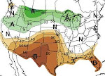
A rain event
 Don't ya love those pretty colors? Well, they do tell a story. Take a Big Picture look at the advance of warmer temps coming in from west-to-east all up and down the Pacific Coastline. These are generally the overnight temps depicted here. Those warmer temps are progged to march right into Eastern Idaho today, tonight and tomorrow. Since they will be accompanied with ample moisture, we are looking at a rain event taking shape here.
So far, it doesn't appear to be enough rain to raise the flood flags, but it's sure going to be interesting to see how it shapes up and progresses through the region.
I'd suspect this event will put a serious dent in the low elevation snow and usher in the infamous "Mud Season" in one fell swoop. I put this surface temp graphic up here this morning because I think it's the key indicator for the next couple of days. Keep an eye on the progression and evolution of surface temps to get a good idea how the Intermountain West will be affected by the incoming Pacific precipitation.
March 1, 2009
East Coast water discussion
 First, let's dispel some media myths that are running rampant tonight. New England is NOT going to get buried in snow! No, it's really not. Yes, it's going to have a nice storm. As you can see from the above graphic, some people in some places are going to get really stuccoed with more than a foot. But that's NOT all of New England. I've beenreading some pretty hysterical media reports tonight. You'd think the Statue of Liberty was going to get covered to her eyeballs! As usual, it's typical media hype going on here. Tomorrow, I am sure CNN will be filled with the obligatory blizzard scenes, people stuck in drifts higher than their house, all the usual suspects. But, honest, it's NOT all of New England, just a lucky few!
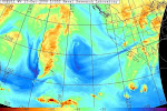
 OK, meanwhile, let's take a look at Polly Pacific. I drew a nice happy face on her earlier today. As you can see, there is an epic fetch and reach to the water vapor tracks right now. It almost looks as if a giant hand is dipping water from the Subtropical region and flinging it at North America. Couple this Subtropical tap with the typical Siberian water tap and you've really got a recipe for some storm action!
I went back and leafed through all of the archived Navy water vapor maps and it sure does look to me like what's hitting New England tonight had its pedigree in the deep tropics. I think it came up on what I've been calling "The Southern Track." If so, this particular storm promises to raise some eyebrows for its timing and intensity. This is March 1st, afterall!
If you spend some time comparing the Indian Ocean, West Pacific, East Pacific and Atlantic water vapor shots on the Navy website, I think that you will become at least as curious as I am about whazzup out there. Idaho seems to be perpetually on the outside looking in lately but some other parts of our landscape are getting stuccoed pretty good!
Once again, I hark back to that "crescendo theory." I keep getting the distinct feelings that this winter really, really wants to go out with guns firing full force in one giant blaze of epic glory! If this current storm is a precursor to that scenario, we could be in for some real memorable Legacy Storms!
And Along Came Polly Pacific
 What can you say about people who play with their food....and weather, too? Maybe they have too much time on their hands? Well, whatever, I couldn't resist on this one. It was crying out for doodling. Photoshop it ain't. We are running late this Sunday morning so Sunday School is also off to a tardy start. Three demerits to the teacher--he's been playing with his food and weather again! (NEWS FLASH--Sunday School has been canceled! That's right, recess came early and now you can all GO PLAY!)
February 28, 2009
National Snow Cover
 Just an FYI. Here's today's Intellicast national snow cover map. And here's the link to find it yourself should the urge ever arise.
Arctic Circle has all the fun!

Those lucky (but frozen) puppies up in the Arctic Circle latitudes have all the fun! Being as it's a Saturday morning, I decided to roam over to Spaceweather.Com and see whazzup. They have some nice aurora photos there such as the one above. The guy who took the one above is Aleksander Chernucho,Mt. Khibiny, Kolyskia peninsula, Russia. The photo was taken yesterday when it was 27FEB here and 28 FEB there. Aleksander has a really cool photo album on a Russian website. It's all in Russian language but the photos speak a universal language and you don't need to know Russian to enjoy them. Note the little slider bar at the top of his album. Play with it and you automatically resize the pictures. COOL!
Well, the Aurora doesn't really have anything whatsoever to do with our North American weather. However, I thought it would be nice to have a "change of pace," so to speak, and put something purely fun and entertaining up on El Blog today.
As winter is fast nearing an end, I think tomorrow's Sunday School will be a most excellent time to begin a review in preparation for your semester final exam. So come prepared to think and learn. Okie, dokie? Have a fun day. You may go play now.
February 27, 2009
NORCAL drought is history
 (See note at end of post.) The February 19 drought monitor already showed NORCAL "going green" again. That's a HUGE improvement from previous drought forecasts. Well, that was more than a week ago. Now, lookie here, the "hazards assessment" shows NORCAL is right back in the crosshairs for incoming Pacific water bombs. Hum...I am going out on a big limb once again and making a statement: The NORCAL Drought is over. It's history. Bambi and Smokey and all the little forest creatures can rest easy this summer--their home isn't going to burn to the ground. Nope, the heat's off up in NORCAL. Whew, that's huge!
Meanwhile, of course, SOCAL can't buy a break. So, that's where we would expect all the dry season fires to be centered once again. But at least the top half of The Golden State is Okie Dokie for 2009. Congratulations, NORCAL!
Note added 28FEB: Arnie What's-His-Name, the California Guv, came out yesterday and declared a statewide drought disaster or emergency or something like that. The article I read says things are 57% of normal. Well, I guess no one's checked the SNOTEL's today as they are all significantly above 57%. The Klamath in NORCAL is running 90% of normal. That's ain't great but that ain't no drought either! When you add in the progged precip upcoming in the next five days, there's no doubt it will be at or above 100% up there. Yes, SOCAL is hurting but NORCAL is out of the woods. Iguess it's politically more expedient to scare the begeebers out of EVERYBODY rather than telling it like it is.
February 26, 2009
Redoubt Dissected!
 Well, folks, this is what a volcanic cone looks like when it gets WAAAY too much attention! People with a heck of a lot of time on their hands find things like "ice pistons" and "slurry tracks." Heck, I thought Ice Pistons was a dormant basketball team! And are Slurry Tracks what happens when you drink to much wine and try to use your iPod? Well, we're having fun with Redoubt, no doubt. Hey, meanwhile, the AVO Crowd has bumped Cleveland to Code Yellow. That's NOT Mellow Yellow--Yellow means something is happening that we need to pay attention to. I clicked through every link I could find but, so far, I haven't found out why Cleveland is now Code Yellow. Cleveland could be a nice little chimney, puffing out periodic doses of Sulfuric Acid into the Arctic Skies. Maybe Ol' Man Winter just doesn't want to end his gig this year! Click here to visit AVO.
Alaskan Action
 I was roaming around looking for a good rendition of the new addition to the sidebar--NWS Offices nationwide. I happened to stumble into the latest Alaskan warning map. Gee, it's a colorful little bugger! So, I clicked off to see whazzup in The Last Frontier, as they like to call themselves. Lots of blizzard warnings, gales, and storms of various varieties. It's kind of interesting, actually. Click here to go to the summary page and then just scroll down and skim all the fun nomenclature. NOTE: We just put a text narrative at the very bottom of this blog explaining how to capture and process a screen shot like the one above. You might enjoy reading it.
Site Stats
A couple of weeks ago I decided to put a "site monitor" on this blog. I wanted to know if people were really reading the blog. Once in awhile, I get a comment but not very often, as you know. So, I wanted to know if I was writing into a vacuum. The last two weeks of statistics tell me that this blog has a fairly regular readership. It looks like a couple of dozen readers visit the blog each day. That's really cool!
THANK YOU, Dear Readers, your visits are appreciated. Your visits also help provide some inspiration to keep improving the sidebar on this blog to provide you with a "one-stop-shopping" experience for your "big picture" weather prognostication needs.
The stats package I chose comes highly recommended. It's called Site Meter and you can click here to review its overall operation. Here are the stats logged since I installed the monitoring scripts:
Visits
Total .......................... 235
Average per Day ................. 23
Average Visit Length .......... 1:30
This Week ...................... 158
Page Views
Total .......................... 523
Average per Day ................. 40
Average per Visit .............. 1.8
This Week ...................... 281
February 25, 2009
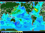
Pretty impressive water vapor!

 Okie, dokie, Weather Fans,let's take a look at the Northern Hemisphere water vapor patterns, courtesy of the US Navy. Gee, something tells me there's a heap o' water heading our way! All of the water taps appear to be working together right now. In football, I think they call this "piling on!" Right now, I have no clue how and where all this stuff is going to smack our continent. But its a pretty safe bet that somebody, someplace is going to get smacked real hard by this stuff. Definitely keep an eye on the jetstream, run those model simulations at least twice a day and rivet your attention to the march of the water vapor across the Pacific.
Some years it seems like Winter just has to end with a GIANT crescendo--kind of like one of those awesome epic symphonies that bring you right up out of your seat as every instrument builds to a nerve-pulsing finale. I am beginning to wonder if this winter is going to be what I like to call a Crescendo Winter. If so, batten your barn, buckle up your babies and hunker down, Nellie!
February 23, 2009
Some Late February Precip
 The Snake River Plain is in line for a wee little bit of precip today. Those "pointy thing" (AKA: the Tetons) to our East will probably get some nice powder out of the deal. The Navy's water vapor maps show a lot of moisture boogie-ing across the Pacific. The QPF people show some decent accumulations progged over the next five days. One of our Official Blog Followers is in the crosshairs of that QPF in Brookings, Oregon. He left a great comment about how the storm impacted their location. Please read it below. Thanks, Dean-O, we sure appreciate it a LOT! Keep 'em coming!
 March continues to show hopeful signs of being a Precip Producer. We are now less than one month away from the official first day of Spring. Generally speaking, big winter storms decline in frequency and intensity after the Vernal Equinox. From that point forward, Old Sol is on a fast track to keep its appointment with the Summer Solstice a mere 90 days away. Enjoy these storms while you can--times, they are a changin'!
February 22, 2009
Sunday School Blow Up!
Greetings and welcome once again to another thrilling session of Sunday School! Today we're going to talk volcanoes. We'd like to give you a firm, fundamental footing on this volatile topic. Volcanic eruptions arguably have more of an impact on our climate than any other single factor. I say "arguably" because some people disagree with that theory. That's a political topic we won't cover in Sunday School today. The study of volcanoes could easily take over your entire life. Some geologists specialize int the study of volcanoes. For our purposes today, you simply need a good grasp on how to review volcano facts and know where to go to keep an eye on evolving volcanic activity. Afterall, this is Sunday School and we have recess coming up soon!
By far the easiest place to learn about volcanoes is Wikipedia. This amazing online resource has most everything an armchair layman would ever want to know about volcanoes. Click here to start your volcano refresher. You will see many links on this "gateway" page. If you want to see just how destructive volcanoes have been during recorded history, go to this link. The Big Grand Daddy of recent volcanoes was Krakatoa. The old funky drawing on this page shows Krakatoa before it disintegrated. There's a famous year in American History called "The Year Without A Summer." It's widely believed that this epic time period was caused by volcanic activity. You can click here to read about "The Year Without A Summer." Obviously, there's enough links from those Wikipedia pages for you to get involved in hours and hours of self-study. I'd recommend that you fully acquaint yourself with all of the Wiki resources on volcanoes. If you are serious about watching weather, you really need to be very well grounded in the science of volcanic activity. You also need to know how to track current volcanic activity.
Let's move into the tracking phase, shall we? As you might expect the US Geological Survey is the world leader in tracking volcanic activity. Click here to go to their gateway website. Be sure to bookmark that website. I think I will put it in the left hand column here, too. Check in on that website often--make it a regular habit, just like watching the jetstream. It's important to note that the mainstream media (that's defined as the media that's obsessed with celebrities and banal fluff) won't alert you to volcanic activity unless it's a huge event. In the meantime, minor volcanic activity can have a big impact on weather. For example, the Aleutian eruptions last summer received scant media coverage because the media was focused on the Obama-McCain-Palin-Biden quadrangle and who cared about some no-name volcano? However, those 3 volcanoes spewed enough stuff into the correct latitudes to really create a notable winter, a winter that generated all sorts of subsequent "media events."
Let's not rag on the media. Let's focus on improving your volcano-watcher skills. One of the largest concentrations of active volcanoes on earth is located on the Kamchatka Peninsula. As Gov. Winky Palin might say, "You can almost see it from Alaska." In any given year, the Kamchatka volcanoes have had and are capable of having an affect on our climate. It's a trifle difficult keeping track of Kamchatka volcanoes because of the language barrier. The graphic on this page shows just how many volcanoes are clustered on Kamchatka. Pretty impressive, eh? Click here to read about KVERT. KVERT is the Russian equivalent of the Alaska Volcano Observatory. Theoretically, the USGS and AVO work hand-in-hand with KVERT. One hopes that such cooperative efforts continue and remain productive and friendly. Luckily, satellite technology really unveils the activity and impacts of volcanoes in this day and age.
There are many more ways to track volcanic activity. However, let's not ramble too much farther here today--it's now Recess Time! Thanks for attending Sunday School this week. Now GO PLAY!
By far the easiest place to learn about volcanoes is Wikipedia. This amazing online resource has most everything an armchair layman would ever want to know about volcanoes. Click here to start your volcano refresher. You will see many links on this "gateway" page. If you want to see just how destructive volcanoes have been during recorded history, go to this link. The Big Grand Daddy of recent volcanoes was Krakatoa.
 The old funky drawing on this page shows Krakatoa before it disintegrated. There's a famous year in American History called "The Year Without A Summer." It's widely believed that this epic time period was caused by volcanic activity. You can click here to read about "The Year Without A Summer." Obviously, there's enough links from those Wikipedia pages for you to get involved in hours and hours of self-study. I'd recommend that you fully acquaint yourself with all of the Wiki resources on volcanoes. If you are serious about watching weather, you really need to be very well grounded in the science of volcanic activity. You also need to know how to track current volcanic activity.
Let's move into the tracking phase, shall we? As you might expect the US Geological Survey is the world leader in tracking volcanic activity. Click here to go to their gateway website. Be sure to bookmark that website. I think I will put it in the left hand column here, too. Check in on that website often--make it a regular habit, just like watching the jetstream. It's important to note that the mainstream media (that's defined as the media that's obsessed with celebrities and banal fluff) won't alert you to volcanic activity unless it's a huge event. In the meantime, minor volcanic activity can have a big impact on weather. For example, the Aleutian eruptions last summer received scant media coverage because the media was focused on the Obama-McCain-Palin-Biden quadrangle and who cared about some no-name volcano? However, those 3 volcanoes spewed enough stuff into the correct latitudes to really create a notable winter, a winter that generated all sorts of subsequent "media events."
Let's not rag on the media. Let's focus on improving your volcano-watcher skills. One of the largest concentrations of active volcanoes on earth is located on the Kamchatka Peninsula. As Gov. Winky Palin might say, "You can almost see it from Alaska." In any given year, the Kamchatka volcanoes have had and are capable of having an affect on our climate. It's a trifle difficult keeping track of Kamchatka volcanoes because of the language barrier.
 The graphic on this page shows just how many volcanoes are clustered on Kamchatka. Pretty impressive, eh? Click here to read about KVERT. KVERT is the Russian equivalent of the Alaska Volcano Observatory. Theoretically, the USGS and AVO work hand-in-hand with KVERT. One hopes that such cooperative efforts continue and remain productive and friendly. Luckily, satellite technology really unveils the activity and impacts of volcanoes in this day and age.
There are many more ways to track volcanic activity. However, let's not ramble too much farther here today--it's now Recess Time! Thanks for attending Sunday School this week. Now GO PLAY!
Redoubt update

 Alaska's Mount Redoubt has been pretty quiet the past few days. The above graphics are the seismic data. You can see how the shaking and rumbling has taped off recently and is nice and tame. The AVO--that's Alaska Volcano Observatory--still feels like Redoubt is a likely candidate to erupt within days or weeks. You can visit their special redoubt website and read about their "scenarios" for Redoubt. They feel a repeat of the 1989-90 episode is most likely. Click here to visit that page. Remember, click the small images to see bigger ones.
February 20, 2009
Some brief thoughts
 As you can see from the above latest QPF graphic, NORCAL is in line for some impressive new precip--over 5 inches if the weather wonks are correct. Idaho is once again on the outside looking in.
 I'm taking a break from posting here on the Winter0809 Blog until Sunday. We're going to a Dog Sled Derby about an hour north of here tomorrow. Hopefully, I will dream up something for Sunday School.
In the meantime, I'd suggest you take a look at the jetstream--it's very fractured and contorted and weird looking. Likewise, seek out the global water views--Asian continues to package and ship some impressive globs of water vapor. Also, please glance at the 6-10 and 8-14 day forecasts on the CPC link. They are both showing above normal precip. In other words, you've all learned how this drill works---do you own forecasting now!
And, just for grins, Google up Mount Redoubt and keep an eye on it, too. Heck, if you do all that stuff, who needs me to write anything here anyway?
Have a great evening and a wonderful Saturday--we will see you Sunday! Cheers, JP
February 17, 2009
Our Sun.
 We are smack in the middle of transition between two Sunspot Cycles. Right now the solar disk is abnormally quiet. "Sun watchers" are getting antsy. No one knows when the sun will switch gears and start exhibiting signs of the new cycle. In the meantime, all eyes are on the sun. ANYTHING that happens on the solar disk is subject of much discussion. And so it is today with this activity. It may not be the stuff of solar storms. It may not be capable of producing a brilliant aurora. But it sure is fun to see.
Why are WE watching the sun, anyway? Well, Bubba, here's the bottom line: when all is said and done, Ol' Sol is our "weather maker." What happens on the sun makes its way to earth and affects our weather. You can take those words to the bank! That's why we watch the solar disk every day of the year, at least when we can get to the internet.
As the sun goes, so goes earth!
February 16, 2009
Just how is Alaska, anyway?
I haven't had time to check in on Alaska lately. I've assumed it's cold up there. I noticed on the NWS Warning composite that the North Slope is under a Blizzard Warning. So I clicked off and, sure enough, it's gonna be your typical way-be-below zero temps with fierce winds and lots of snow. Hum...sounds intense! Meanwhile I clicked off into the Bering Sea and, well, yeah, 50 knot winds, 20+ foot waves.
It's not so bad in the lower Alaskan latitudes--just a normal winter. However, it's a good idea to keep an eye on Alaska. If it gets tropical up there, I'd guess the affects of the summer volcano ash and gas are history. It looks like Ol' Man Winter has Northern Alaska by the throat right now. Cold. Snow. Wind. High Seas. All the usual suspects.
It's not so bad in the lower Alaskan latitudes--just a normal winter. However, it's a good idea to keep an eye on Alaska. If it gets tropical up there, I'd guess the affects of the summer volcano ash and gas are history. It looks like Ol' Man Winter has Northern Alaska by the throat right now. Cold. Snow. Wind. High Seas. All the usual suspects.
It all depends...
 Whether our weather will continue this pattern into March depends on the jetstream and the water vapor supply. Right now, it looks good. As you can see, I've annotated today's jetstream to show the Northern Hemisphere symmetry. Remember that "wagon wheel" analogy I used quite some time ago? Well, this is as symmetrical as the wagon wheel spokes get! The jetstream is exhibiting some real nice behavior in this graphic. Meanwhile, the water vapor production (see below)continues to look good. Siberia is very generous to us. That on-again, off-again subtropical tap shows promise as well.
As you may recall, we started this blog many moons ago on the premise that the Summer 2008 Aleutian volcanic eruptions were going to distort our Northern Hemisphere winter weather patterns. I think we can all safely agree that those patterns have helped produce a real memorable winter. Whether it was due to the volcanic factor will be the topic of much discussion as the climatological postmortems are rolled out in the months ahead.
 Let's assume for a minute that the volcanic factor was, indeed, at the root level of this winter's interesting weather. If so, the question becomes: "Have those volcanic factors diminished?" The answer would be "Probably." It takes many months for the gas and ash to disperse enough to lessen its impact on deflecting solar energy back into space. However, I'd be inclined to wager there's enough of it left to eek out another 4-6 weeks of solar energy disruption in the far northern latitudes. Maybe less, maybe more. So, if we carry that line of speculation forward, I'm beginning to be inclined to think that March could be a Pretty Good Precipitation Producer. Maybe I should coin an acronym for that--PGPP.
The wild card in this deck remains Mt. Redoubt. So far, it's been a real dud--a little steam here, a little rumble there but nothing remotely resembling the early dire warnings issued by the Chicken Little Volcano Heads. But you never know--a volcano has its own clock that's ticking its own time. We could wake up one morning to a major motion picture on the CNN Headline News. There could be ash and gas getting shot 40-50-60,000 feet into the polar latitudes.
I can tell you one thing pretty much for sure. If Redoubt blows it's top, there's no doubt we're in for a cold, wet spring and probably a cold wet early summer as well. That's where the wild card lies.
When's the party over?
 The screen shot on the right is the overall QPF for the next five days. The left shot is the current NWS warning composite as of Monday morning. That Winter Storm Warning coloration pretty much covers most of the Sierra Mountains. During the next five days, the same area is progged to get almost 3 inches of precip. Meanwhile, the 8-14 forecast shows above normal precip for a wide area of the West.
Our next post will (above) will take a look at the water vapor patterns and the jetstream. The question arising now is "when's the party over?" No pattern persists forever. The first day of Spring is less than five weeks away. In the past few years, the party's ended right about this time of year. In the Good Ol' Daze, March could be a real weather & water producer. Will the good times keep rolling right into March? Fourteen days puts us into early March!
February 15, 2009
Tell it like it is!
Hey, those Reno weather wonks are gettin' some ATTITUDE! Check this snippet from the 7:26 pm 15FEB AFD:
"NICE WARM CONVEYOR SHOWING UP ON 290-300K ISENTROPIC SURFACES EXTENDING FROM OFF THE COAST TO TAHOE/LASSEN. AS FAR AS MODELS GO...HAVE TOSSED THE NAM IN THE TRASH FOR THIS STORM. IT HAS NOT HANDLED THE POSITION OF THE BAND WELL AT ALL SINCE FRIDAY AND WAS EVEN DRY FOR TAHOE UNTIL 21Z TODAY?!?!?!
Yeah, "TOSSED THE NAM IN THE TRASH!" Right ON, Bro! Sometimes these NWS people pay WAY too much attention to their models. They wring their hands and agonize about what the models "mean." It grows old and annoying sometimes. It's refreshing to read how somebody in Reno simply said, "Throw the SOB in the TRASH!" Yeah, that's my kinda attitude!
Lately, Reno gets my vote as the "GOTO" place for an exciting AFD. They will probably soon get called on the "Climo Carpet" for all their enthusiasm and straight talk. But, hey, let's enjoy it while we can.
Spaceweather
 The photo above is just a reminder to visit Spaceweather often. Don't forget! That website simply ROX~!
Sunday School has Visual Aids!
Hey, there, Class, Thanks for showing up for Sunday School this morning! As promised last week, we're going to walk you through the new-fangled NRCS method for finding out the "percent of average" of any given watershed snowpack. It used to be pretty simple. But you know the gubmint motto--"if it ain't broke, change it!" The new method is pretty good but I miss the old graphs-at-a-glance. This one's OK and I guess I will get used to it. Maybe you will, too. Whatever the case may be we gotta "dance with the one that brung us" and, in this case, that means the good ol' NRCS.
Ok, this Sunday School is gonna be real short and, hopefully, sweet. Why? Well, it's bright and sunny outside and I am itching to git outdoors and "get a life." That's why!
You begin this process by clicking on the NRCS link in the left hand column. By now, you should now that drill. Then you will have to follow some steps that aren't really too complicated. However, there's enough steps that you can get lost and take a wrong turn. That's why I made these graphics below. Just follow the steps and tailor your final approach for whatever state-of-mind suits you and then you're cleared for landing on Runway 0809! Have a great day. Study your Visual Aids, practice a little bit and then GO PLAY!


PS--I forgot to mention that one nice thing about the new format is that you can get the "percent average" for any given day, including today, February 15!!! That's actually pretty cool.
February 14, 2009
More focus on California
 Here is some really strongly worded language:
"California is facing the most significant water crisis in its history. After experiencing two years of drought and the driest spring in recorded history, water reserves are extremely low. With the Sacramento-San Joaquin Delta ecosystem near collapse, court-ordered restrictions on water deliveries from the Delta have reduced supplies from the state's two largest water systems by twenty to thirty percent.
Drought conditions in the Colorado River Basin and a Sierra snowpack that is now dangerously unreliable due to global climate change, is leaving many communities throughout California facing mandatory restrictions on water use and/or rising water bills. If the drought continues into next year, the results could be catastrophic to our economy." Go to the website where we found this snippet.
The above map linked from the Climate Prediction Centers says it all--NORCAL is at ground zero of a genuine water crisis. Right now, tonight, even as we write this blog post, NORCAL might just be getting a "get out of jail" pass and California might dodge an intergalactic bullet. NORCAL is getting plastered tonight.
It's awesome, it's epic and it's great!
Above you see the water vapor blanketing the most hard hit part of drought stricken California. Below, you see a screen shot of the next few days of accumulated precipitation this area. At this point in time, it really can't get a whole lot better than this!

Da BUOY
 We wish to encourage our Dear Readers to check "Da BUOY!" NOAA and their cohorts run a first class buoy operation spread all over the far flung ocean surface. When you see something happening on a Navy water vapor, run along and check Da BUOY!
 It sure looks like that big Wadzilla up north is huffing and puffing its way into a happening deal. Some of the winds up there early this morning were yawners and now they are gusting to 40+ knots. The wave heights haven't picked up too much, maybe 10-13 feet but the winds auger for an increase in the waves, too.
With the internet and satellite technology we have now, there's no excuse for not beaming into every little nook and cranny that you can. Ocean buoys are a priceless resource. Check 'em out!
Wild West Jet
 Today's jetstream diagram reminds me of either rodeo or some scene from a 1950's black and white Western shoot-'em-up. It's rip snortin' and rarin' to go! It's been quite a long time since I've seen anything this shredded in the jetstream. Heck, it might even be Jetstream Triage! Where do you look first to analyze and "treat" the situation?
  Meanwhile, a glance at the water vapor situation this morning says that we're still on tap for a few more waves of water to wash ashore. The Western Pacific shows that is is attempting to reconnect its firehose the Phillipino hydrant. If we get that subtropical connection going again, WHAA--WHOOO!!!!
NORCAL is getting smacked hard as we write this, high winds, rain, snow, the whole buffet of winter jingo and major lingo. Ironically, it's NORCAL that shows up the "reddest" in gubmint's drought diagram. This type of action almost certainly will alleviate the severity of that situation.
To see it unfold, if you're interested in such stuff on a lazy Saturday morning, here's what I would recommend. First, click on the National warning map at left. Then click into one of the little colored areas up in NORCAL. Have fun reading about all the mayhem. Then start Googling various community newspapers and TV stations in that region. That should keep you entertained at least until lunch time.
February 12, 2009
A moment of truth
All eyes and hopes are on California right now. Californians might not know or realize it but lots of humans elsewhere are praying that they pull through the epic drought that they are facing. Their best odds are coming up in this next pulse and parade of storms.
I was roaming the various AFD's this evening and I found a rare bit of personal emotion being expressed. Normally, the NWS weather wonks keep their personal feelings out of their discussions. It's all "cut and dried" techno talk.
This snippet came out of Reno's afternoon AFD. You can almost sense the helplessness and near hopelessness in these words, as well as a sense of prayer, too. Maybe I am reading too much into a few scant words. I don't think so.
IT IS VERY IMPORTANT TO NOTE THAT THE 18Z RUNS...AND 12Z EURO ARE ALSO TRENDING SLOWER AND A BIT DRIER. EVEN WITH THE DRIER SOLUTIONS...1-2 FEET OF SNOW FOR THE SIERRA STILL LOOK POSSIBLE...BUT NOT THE 2-4 FEET INITIAL INDICATIONS SHOWED. IT IS EVEN POSSIBLE IF THE LOW CUTS OFF ENOUGH THAT WE DONT GET THAT MUCH AT ALL. RIGHT NOW...MY GUT FEELING IS THAT THE 12Z EURO/18Z GFS IS THE WAY TO GO...ALTHOUGH MY CONFIDENCE IS NOT ALL THAT HIGH. GIVEN THE WAY THIS WINTER HAS GONE...ALMOST EXPECTING THAT I AM STILL TOO WET. I HOPE I AM NOT. WALLMANN Check out Buoy 46002--Gusting to 39 knots--waves to 20 feet! YES!
I was roaming the various AFD's this evening and I found a rare bit of personal emotion being expressed. Normally, the NWS weather wonks keep their personal feelings out of their discussions. It's all "cut and dried" techno talk.
This snippet came out of Reno's afternoon AFD. You can almost sense the helplessness and near hopelessness in these words, as well as a sense of prayer, too. Maybe I am reading too much into a few scant words. I don't think so.
IT IS VERY IMPORTANT TO NOTE THAT THE 18Z RUNS...AND 12Z EURO ARE ALSO TRENDING SLOWER AND A BIT DRIER. EVEN WITH THE DRIER SOLUTIONS...1-2 FEET OF SNOW FOR THE SIERRA STILL LOOK POSSIBLE...BUT NOT THE 2-4 FEET INITIAL INDICATIONS SHOWED. IT IS EVEN POSSIBLE IF THE LOW CUTS OFF ENOUGH THAT WE DONT GET THAT MUCH AT ALL. RIGHT NOW...MY GUT FEELING IS THAT THE 12Z EURO/18Z GFS IS THE WAY TO GO...ALTHOUGH MY CONFIDENCE IS NOT ALL THAT HIGH. GIVEN THE WAY THIS WINTER HAS GONE...ALMOST EXPECTING THAT I AM STILL TOO WET. I HOPE I AM NOT. WALLMANN
 Check out Buoy 46002--Gusting to 39 knots--waves to 20 feet! YES!
Precip perks up
 Well, this graphic is pretty self-explanatory. If you've been watching what we've been posting, you can quickly note the quantum leap in precip in this graphic. It's huge--almost Reichter Scale!
Wow--are the Rain and Snow Gods being "nice" to California or what?
It's been a long time since we've seen California in the "red zone" of a precip event. Ignore the five inch area for a moment and look inland in the Northern Sierra and you're seeing 4.0-4.6 inches of precip. If the dynamics are correct that could translate to 3-4 feet of SNOW! That's HUGE!
February 11, 2009
GFS animation + Accuweather drought story
We all read a lot about the models that the NWS Staff uses to make their forecasts. One of the primary models is the GFS. Click here to see it's progression of storms hitting California. It's real impressive!
Well, well, well! I went to Accuweather tonight simply to type in the Idaho Falls Zip Code to get tomorrow's forecast. Lo and behold, they posted a story about 7 pm tonight saying that the California drought might be coming to an end! Hey, it's great to have somebody like Accuweather saying this. YAAA-HOOO, I don't feel like the Lone Ranger any more. (The link posted yesterday no longer works.) I snagged one of their photos because I like the way it looks. Kinda art deco in a retro-lineal sort of way, eh?

Well, well, well! I went to Accuweather tonight simply to type in the Idaho Falls Zip Code to get tomorrow's forecast. Lo and behold, they posted a story about 7 pm tonight saying that the California drought might be coming to an end! Hey, it's great to have somebody like Accuweather saying this. YAAA-HOOO, I don't feel like the Lone Ranger any more. (The link posted yesterday no longer works.) I snagged one of their photos because I like the way it looks. Kinda art deco in a retro-lineal sort of way, eh?
All ashore!

 Here are the twin Northern Hemisphere views courtesy of the US Navy for Wednesday morning. I don't have time to draw little funky lines on them today. I wanted you to see them without having to surf around the Navy website. Also, I wanted to archive them for future reference. Note the CPC's 6-10 day forecast below. (Click on the little one to see the big one.) It has California right smack in the crosshairs of all the incoming action from El Pacifico. I am already beginning to wonder if these great "gifts of the sea" might not change around the urgent drought dynamic facing California.
  We're talking a lot of water progged for California. We're talking rain and snow that could continue off and on for days.
Yes, we will read about the inevitable mudslides, dramatic rescues and "all the usual suspects." However, behind the hype and hyperbole of the CNN Headline news, we could be witnessing a "sea change," pun intended, with regard to the California water supply situation. This type of incoming precipitation has potential to also really change the summer fire dynamics. All of this portends good news instead of continuing dire bad news. California is one of those places that seems to always attract the dramatic. Perhaps that's because of the state's size, style or geography. Who knows? It sure looks like another dramatic chapter is about to unfold in The Golden State. It definitely has me on the edge of my seat!
Subscribe to:
Posts (Atom)