January 24, 2009

Rain on The Plain In Spain

News readers are well aware of a terrific storm smacking Southern France and Northern Spain. It's deadly and numerous people have been killed. Officials are calling it the worst such storm in December 1999. Here is one key snippet from BBC: "The storm system has been gathering strength over the past few days as it moved over the relatively warm waters of the western Atlantic." As you can see from the lower graphic, there is a very warm area out in the middle of the Atlantic. This area is almost a mirror image of a similar warm area off our West Coast out in the Pacific.

These types of concentrated areas of abnormal Sea Surface Temperature (SST) warmth can have a great impact on weather systems. Not every system will be impacted. But you can easily see how the current mayhem in Spain has been exacerbated by that warm area in the Atlantic.

I bring all of this up as a caveat--the very same thing could indeed happen with one of the remaining systems due to wash ashore in our neck of the woods. It's fairly unlikely, mind you, but it IS a possibility. Keep an eye on those SST's via the link at left. The very same sort of thing could happen to our West Coast that is now happening to Spain.

January 23, 2009

Back In Business

Here's the "proof of the pudding." You can see the return of the periodic blobs of water vapor rolling out of Asia into the Pacific for their final approach to the North American Continent. Couple this with the wild and crazy rock and roll jetstream and you have a recipe for another real stout round of Ol' Man Winter! We checked the Climate Prediction Center's website just to be sure. Yep, the 8-14 day and the 30 day forecasts both call for "above normal" precip in the PAC NW. (Sorry, Arizona, yer gonna be left off the Party Boat.)

Sneaky Snow Attack

We woke up earlier than normal this morning--4 am. The light seemed to suggest it was after 6 am. HA! It was because of a stealthy snowstorm that arrived after we went to bed last night. Here in Idaho falls, we're looking at about 6 inches of snow--it's the first storm in weeks. (NOTE--Once I got out in it, I'd say it's 8 inches.) It's snowing heavily as I write this so I suspect we will get more of the white stuff. Definitely time to fire up the snowblower.

That high pressure really lulled us into "lah-lah land." It seemed like the sun would shine forever! The KIDA obs say we've rec'd more than a half inch of precip. That would be consistent with the old-fashioned 12:1 snow to water ratio. Interestingly, the boyz and ghurlz working the night shift at Pocatello NWS must be asleep at the switch. The warning map shows nothing to indicate the area just got whacked by snow. Go figure.

January 22, 2009

Jet On Meth

Study this jetstream graphic closely. Click on it for the larger version. There are some really wild kinks and twists and turns on this jetstream. Heck, there's almost the equivalent of an "abandoned meander," in river runner terms. Look over around the UK and check out that little dipsy-doodle.

This jetstream patterns is beginning to show what we really, really hope to see--CRAZY BEHAVIOR! A crazy jetstream is a good jetstream--at least if you hope to have a wild and wooly winter with lots and lots of cold and snow. A zonal, lazy jetstream is not only boring, it rarely produces bizarre weather filled with extremes. CRAZY jets are like a rock and roll band on drugs. (See 1960's Rolling Stones.) CRAZY jets do crazy things.

A NWS Weather wonk once taught me eons ago to imagine a 19th Century wagon wheel balanced atop the North Pole. He said the jet would be the iron rim of the wheel. If things were lazy and boring all the spokes of the wheel would be the same length and the jet would be zonal and just go round and round. However, he said if the spokes go to be different lengths, then the rim would go crazy. That's the pattern we want to see--a wagon wheel gone wild!

The trick is to visualize that the wagon wheel spins round and round on the North Pole axis. Once the spokes get all out of kilter, they simply keep things out of whack all around the whole planet. It certainly looks to me like we're getting into one of those enviable patterns.

I'm tempted to break out into a river runner wild cheer but I am going to save that irrational exuberance until I know for certain that this pattern is indeed delivering the goods. (Note added 6 am 23JAN: Well, it's delivering the goods as of this morning!)
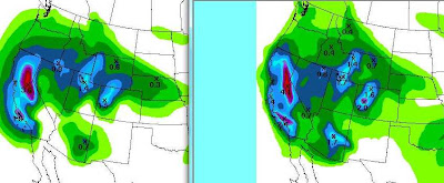
The QPF numbers are on the rise. Check the difference between yesterday's QPF and today's You will note some very interesting differences. The net numbers have increased. The areas of coverage are larger. Overall, this is a very good trend.
By the way, what does QPF mean? It's "Quantitative Precipitation Forecast." All gubmint lives by acronyms but the weather wonks are especially addicted to acronyms. I'd suspect they sit around in the deep dark of night secretly plotting to convert all known human activity to an acronym!

Despite their penchant for acronyms, the Wonks also enjoy use of an occasional fun word. Check this snippet from today's Reno AFD: "A RELATIVELY NARROW BUT HEAVY BAND OF RAIN IS MOVING SLOWLY ACROSS NORTHERN AND CENTRAL CA THIS MORNING AS AN UPPER TROUGH MAKES ITS WAY ONSHORE. THIS BAND OF HEAVY PRECIP IS BEING FED BY A JUICY SUBTROPICAL CONNECTION OFF THE BAJA COAST."
Juicy, huh? Way cool, Dude!

January 21, 2009

Lee Waves

This is a picture of some "lee waves" on the east side of the Rocky Mountains near Boulder, Colorado. Click here to read about lee waves. If you are reading this soon after I posted it, please go to Spaceweather and read about this particular photo and gain some additional insight on lee waves. That Spaceweather website is easily the most fascinating day-to-day website I've ever encountered--at least if you're interested in strange weather and space phenomena.

Bye, Bye, High!


Looks like our mid-winter break is finally coming to an end. Here's a Wednesday morning Pocatello AFD snippet:

.SHORT TERM...TODAY THROUGH FRIDAY NIGHT. UPPER RIDGE AXIS CONTINUES TO SHIFT EASTWARD THIS MORNING AND IS PROGRESSING INTO WESTERN WYOMING. A MULTI-FACETED PACIFIC SYSTEM WILL MOVE ON SHORE TODAY WITH SEVERAL DISTINCT AREAS OF CIRCULATION. SATELLITE IMAGES DEPICT A CIRCULATION WEST OF LOS ANGELES WHILE A SECOND AND THIRD MORE POTENT SYSTEM WEST LIES WEST OF VANCOUVER ISLAND AND IN THE NORTHEASTERN GULF OF ALASKA...

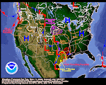
As you can see from the above graphic, your friendly NWS weather wonks are showing some medium decent precip over the next five days. Let's hope they are correct.

The Idaho-Wyoming snowpack has held up well during this protracted high pressure system. Island Park still has about 3 feet. Two Ocean Plateau in Wyoming is a whisker short of 6 feet. Snow water equivalent has held steady. Most watersheds are at or above 100% of normal for this time of year. One more big round of snowstorms would put every drainage in great shape for spring. With any luck at all, we hope to see February deliver one or two more feet of snow across the Intermountain West.

January 18, 2009

Out On A Big Limb Here

OK, we're going out on a Big Limb here and we taking a saw with us. We're cutting the limb behind us! If you've never tried this trick, I highly recommend it. Put yourself someplace where you can't get back--and then cut the limb off. Wow, it's fun!

Anyway, we think the high pressure is dead--toast, DOA, history. Yeah, it's still here--today in Idaho Falls was majestic--surreal, actually. But today was the high water mark of this puppy. It's outta here. So what if the jetstream is bent backwards? So what if chinook winds are toasting Alaska? So what if people think happy times are here again? It's time for change--dramatic change--and change is coming to your local neighborhood theater soon. I'd expect this high and all of its baggage to be out of here within two days, possibly earlier, but no later than mid-week. Then, the zonal jet will come back and kick anatomy. We've been saying the water vapor blobs are stacked up--you can see them above.

The Big Question Mark (no pun intended) is "what's happening to the polar airmass?" If, as we suspect, the polar air is just as cold as it was prior to this high pressure regime, then it will reassert itself very soon. If some voodoo magic made all that cold air disappear, then we will apologize and you can get your money back for reading this blog. (Your check is in the mail! Bailout money, of course.)

But we don't suspect that any kind of known voodoo has made that frigid polar airmass disappear. We suspect it will be back with a real attitude. And we suspect that the snow events of recent weeks will be just a "tune up" for what's in store.

Yeah, this is Big Limb stuff. When you go out on a limb this big and start saying the sky is falling, you've got nothing to gain and everything to lose--credibility-wise. But, hey, if we didn't do it this way, it just wouldn't be any FUN!

Enjoy the outcome & Cheers!