December 30, 2008

Deja vu?

Phil: Do you ever have deja vu Mrs. Lancaster?
Mrs. Lancaster: I don't think so, but I could check with the kitchen.

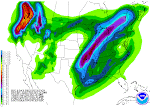
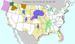
Above is one of my favorite quotes from the movie Ground Hog Day. Bill Murray is in the dining room of his B&B. Well, in this case our weather deja vu is all coming from the same kitchen right now--Siberia. Big Wadzillas there are ganging up and rolling offshore to bluster across the Pacific and splatter the Northwest with fat gobs of rain, ice and snow. The pattern looks to continued abated for awhile. Today's QPF graphic looks almost exactly like one from a few days ago. Deja Vu? You betcha!

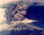
Meanwhile, one of the Jackson ski resort restaurants sustained avalanche damage yesterday. It was a front page story in the Idaho Falls paper. They claim to have rec'd 5 feet of snow in 7 days. Avalanche deaths are soaring, 9 since 14DEC, plus another 8 in Canada over the weekend.

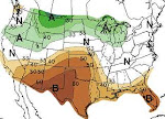
The jetstream has gone zonal--basically that means Old Man Winter is blowing full force in a straight line right smack across the Pacific. No dipsy-doodle whippy kinks and bends for the jetstream right now. Don't worry, though, they will be back!

People really begin to pay attention to the gubmint's snow data as of 01JAN each year. That's the first report that really matters. The US NRCS will publish monthly Snow Reports for each state January through May. Click here for a tremendous narrative summary of the NRCS Snow Measurement & Reporting program.

December 28, 2008

Wadzilla?


Hum...that's one heck of a wad o' water vapor out there in the Pacific. It's heading our way. We nicknamed it Wadzilla.

Meanwhile, the jetstream is having more fun than a contortionist at a ten cent circus. It's got itself an actual 90 degree kink in it. Normally, the jet rocks and rolls with a wavelike action--getting real angular, so to speak, just ain't part of the jetstream's life plan. It won't last long so enjoy the anomaly while you can.
Remember, you can click on any image on this blog to see a larger version. The Blog Gnomes automatically shrink images down to tiny little files. The larger original lives under the Gnome Bridge with the Blog Troll.

Chetco rose 15 feet


Well, the Chetco is probably a river you've never heard of. It drains down out of SW Oregon's Coast Range and meets the sea at Brookings in Curry County, Oregon. We camped on the banks of the Chetco for a few days back in 2002. These coastal streams are very accustomed to sudden high flows. The Chetco rose a total of 15 feet and reached a peak flow of 51,000 cfs. Only minor flooding damage was sustained.

How do you find this stuff? Good question. Google "Oregon Real Time Stream Flows" and then scroll all the way to the end of the list. There is it like magic.

Silverton was no fluke

Sunday morning we are roaming the SNOTEL sites looking for Big Snow. The "Upper San Juan" site in SW Colorado caught our eye. This site is actually Wolf Creek Pass on US Highway 160 NE of Pagosa Springs. It actually is the very tippy top of the San Juan River headwaters. River runners get giddy & goofy when Wolf Creek has a lot of snow--it's means "The Juan" will be a hot ticket during upcoming runoff. Well, back to the story: This SNOTEL is sitting this morning at 81.7 inches of snow. Yesterday was 87.9. That's considered normal settling in deep snow. The interesting factoid is that the site gained 36.4 inches of snow in five days! That translates to a gain of 7.1 inches of SWE, AKA Snow Water Equivalent. SWE is the real water that's hiding in the snow.

We had a question recently on how to find this data yourself. It's pretty easy. Click on the top link at left--the one for SNOTEL Sites. On the right side of the new page you will see a link Snow Depth called "Products." When you click there, you can get a text summary of the snowdepth at all sites within any given state. After you find a particular site of interest, return to the main SNOTEL page, click that state, choose the site that caught your attention and then click on "7 Day Snow Depth" by either hour or day. It's really quite simple once you get the hang of it.

One other cool thing you can do is find the SNOTEL site on a satellite, terrain or highway map using Google Maps. Each SNOTEL site has long-lats. Plug them into the Google maps search field and, viola, there you have it! Click the example below for a larger version.

December 27, 2008

Silverton stuffed!

This story was posted late 27DEC by United Press International:

SILVERTON, Colo., Dec. 27 (UPI) -- This week's winter storm that brought blizzards to the U.S. mountain West dumped 4 feet of snow on high-altitude Silverton, Colo., officials said.

The small town high in the San Juan Mountains took the brunt of the Christmas Day storm as ferocious winds whipped the snow into 8-foot drifts, The Denver Post reported Saturday.

"They got the brunt of it," National Weather Service meteorologist Bryon Lawrence told the newspaper.

The storm closed Molas, Coal Bank and Red Mountain passes, boxing Silverton in and closing the town's two ski areas. But officials said the resorts would likely reopen as soon as the roads were plowed, with the Silverton Mountain Ski Area expected to boast a record-breaking 200 inches of snow -- or 16.6 feet, the Post said.

"The roads being closed has been challenging," ski area spokeswoman Jen Brill told the Rocky Mountain News. "But I never will say that there's any such thing as too much snow. You won't hear that out of my mouth."

There's a lengthier version of this story here in the Denver Post.

Batter Up!


Well, let's take a break from all the action here in the Lower 48 and take a trip to the Russian outback. I've tinkered with some graphics here to show you the totally weirdo jetstream coupled with an equally weirdo wad of water vapor. This is a very unusual pattern, folks. I'm not sure how this one will play out as I can't recall ever seeing such a strange pattern before. It looks unusually wet, quite large and possibly ready to set up a very cold snowy pipeline out of Alaska. Weird things like this often change as quickly as they appear so I won't worry too much about it right now. It's kind of like having a rattlesnake along your far back fence. As long as the snake stays out there, no one's too worried. It's only when the snake comes onto your patio that you call Pa-Pa for the shotgun. If there was ever a coiled snake pattern sitting out along the back fence of the Russian regions of Siberian--this is it!

Upper Snake smiling

If a watershed could smile, we suspect the Upper Snake is smiling today. The Camp Springs, Maryland, weather wonks have this to say: "3-DAY SNOWFALL TOTALS OF 2-3 FEET ARE PROJECTED ACROSS THE CASCADES OF WASHINGTON...MOST OF NORTHERN IDAHO...EXTREME NORTHWEST MONTANA AND THE TETONS..." Pocatello NWS 2 pn 27DEC AFD says "SEEMINGLY ENDLESS STREAM OF PACIFIC MOISTURE IS POURING INTO THE REGION." The QPF graphs shows a direct hit on Y-stone and the Tetons. This is real good news for Tater Nation as the NRCS says the Upper Snake only needs a 90% snowpack to have adequate irrigation for the 2009 growing season. If the latest forecast comes true, Tater Nation's ruler King Tot will throw a New Year's party!

Meanwhile, check the 27DEC warning mosaic in the Midwest. It's hard to remember a weirder grouping of warnings all bunched together. You've got a tornado watch, a flash flood warning, an ice storm warning and even a red flag warning way down south. What an eclectic mix of watches and warnings!

Meanwhile, parts of the PAC NW coast are indeed getting some decent rainfall. NW Oregon is under a flood warning so we will probably have some media coverage of the results here pretty soon. Stay tuned.

December 26, 2008

Polar Crown Prominence


Here's a real "dousey," as Ned Ryerson would say in Ground Hog Day. If you go to Spaceweather, you can read all about it. Meanwhile, I figured I'd post it here because it's so danged beautiful and mysterious and even a wee bit Gothic.

When it rains it pours


Above is the precip prediction mosaic for the lower 48. Pretty danged impressive precip figures progged out on the coast and up in the Idaho Panhandle. If these figs come to pass, somebody, someplace is somehow gonna be in a world o' hurt! (NOTE: We liked this graphic so much we found its source and made it a permanent part of our links at left.) When these big Pacific storms roll ashore and dumpall their water on the windward side of the Cascade Range, it always reminds me of a huge bomber hugging the deck and speeding toward its destructive destiny. These types of storms are so awesome and magnificent. I try to imagine the sheer weight of the water in the sky. All weather is wonderful but winter weather is even more so!

December 25, 2008

Snow snippets

(Edited 27DEC) We roamed El Net on Christmas looking for "snow snippets."

We continue to look for little gems. on 27DEC we found this in a editorial by the Portland Oregonian newspaper: "...a storm rated as the region's worst in 40 years." The Portland NWS verifies this here.

The snippets below were the ones found on Christmas Day.

Here's a few we found in one single AP article:

"A blizzard warning for the San Juan mountains in southwest Colorado warned that as much as 3 feet of snow was possible."

"About 2 feet of snow fell overnight in the mountains around Lake Tahoe, bringing totals at some resorts in the past two weeks to 10 feet."

"Up to 18 inches of snow was possible in the Cascades; in the eastern half of the state Spokane, expected 5 to 7 inches of new snow atop a heavy layer that accumulated during weeks of storms."

From a a different source comes this gem:

"In Canada, meteorologists are predicting the first coast-to-coast white Christmas since 1971."

From Wisconsin media we learn:

"Wednesday's 2.9 inches of snow in Madison pushed the December total to 36.1 inches, breaking the December record of 35 inches set in 2000, the National Weather Service reported. The normal December total is 9.1 inches and last December's total was 26.4.

It also pushed the calendar year 2008 total to 106.8 inches, far above the old record of 82.6 inches in 1994.

The lone remaining record standing is the all-time monthly total of 37 inches set in February 1994.

And this from an agricultural publication:

"The snow depth at Claifornia's Big Bear Lake climbed to 54 inches. Big Bear Lake's greatest snow depth on record was 58 inches on February 3, 1979."

Red is a rare color


Yep, red's a rare color on these here maps. Red is the appropriate color for a blizzard warning. You might call it Code Red. All kidding aside, red is not a good color to see on a NWS warning map. It means people who are out in those conditions are facing very dire straits. Our prayers go out to those who are traveling Code Red areas on Christmas Day. (Click the little picture to see the full size version.)

Frisky forecasters

Once in awhile the normally dour NWS forecasters kick up their heels and add itty-bitty little personal comments in the AFD's. ANd so it is today--Christmas Day--that the Pokie-Mon (That's our private term for Pocatello NWS Forecasters) added the nifty little header the 3 am AFD:

WELCOME TO THE CHRISTMAS 2008 WINTER STORM FOR EASTERN IDAHO. A VERY COMPLEX AND DANGEROUS SITUATION HAS DEVELOPED ACROSS SOUTHERN AREAS. CURRENT SATELLITE AND RADAR SHOW PLENTY OF SNOW ACROSS THE AREA. ADDRESSING WIND AND HEAVY SNOW FIRST...BLIZZARD CONDITIONS HAVE DEVELOPED ACROSS PORTIONS OF THE MAGIC VALLEY AND SNAKE RIVER PLAIN. WIND GUSTS OF 50 TO 60 MPH ARE COMMON AT 245 AM IN FROM AROUND FT HALL TO POCATELLO TO WEST TO BURLEY AND ACROSS THE SOUTHERN HIGHLANDS. THE STRONGER WINDS ARE NOW BEGINNING TO SPREAD FARTHER NORTH INTO THE SNAKE PLAIN. THESE AREAS WILL CONTINUE TO SEE VERY STRONG WINDS UNTIL LATER IN THE AFTERNOON AS THE FRONT PASSES THROUGH THE AREA. FOR THE REST OF EASTERN IDAHO...SNOW AND GUSTY WINDS WILL CREATE HAZARDOUS DRIVING CONDITIONS AS WELL THROUGH TONIGHT. SNOWFALL TOTALS THROUGH 5PM TODAY ARE GENERALLY 5 TO 10 INCHES WITH HIGHER AMOUNTS IN THE SNAKE RIVER PLAIN. FOR THE CENTRAL MOUNTAINS ARE 4 TO 8 INCHES WITH UP TO 10 INCHES ON THE PEAKS IN THE LOST RIVER/PAHSIMEROI REGION...THE REST OF THAT AREA WILL SEE 9 TO 12 INCHES IN THE VALLEYS WITH UP TO 2 FEET IN THE SAWTOOTHS. OUR OTHER MOUNTAINOUS AREAS WILL SEE 8 TO 13 INCHES IN THE VALLEYS WITH UP TO 2 FEET IN THE IDAHO WASATCH. THE EXCEPTION WILL BE THE SOUTH CENTRAL HIGHLANDS WHERE 5 TO 10 INCHES TOTAL IS FORECAST.

Washington Emergency

On Christmas Eve, Washington State Gov. Chris Gregoire proclaimed a state of emergency due to the weather and storms across the state.

"Snowfall has reached record or near-record level in 30 of the state's 39 counties," Gregoire said in a statement. "Many communities, especially in eastern Washington, are expecting as much as a foot or more of additional snow this holiday weekend.

"This proclamation will enable the state to respond quickly to local requests for emergency support and assistance arising from these new storms."

Things could go from real bad to really terrible for Washington State. Oregon is looking at 2-3 inches of rainfall over the weekend--with the snow level ABOVE the pass levels! WOW--that could cause real headline floods throughout the Oregon. I'd reckon Washington could be in line for some of the same. OUCH!

Here's The Portland Christmas discussion:

WHAT IS BECOMING MORE CLEAR HOWEVER IS THAT THE PRECIPITATION AMOUNTS THE COAST RANGE AND CASCADES ARE LIKELY TO RECEIVE WILL BE RATHER HIGH. MODELS SHOW EXTENDED PERIODS OF 20-40KT OF WESTERLY MID LEVEL FLOW FROM SATURDAY AFTERNOON THROUGH TUESDAY. RIGHTFULLY SO...MODELS SHOW UPWARDS OF 2 TO 3 INCHES OF QPF DURING THIS TIME PERIOD. THE RAIN/SNOW LINE SHOULD BE ABOVE PASS LEVELS THIS WEEKEND AND EARLY NEXT WEEK...SO LOW LEVEL SNOW WILL NOT BE AN ISSUE. HOWEVER...THE SKI RESORTS COULD END UP WITH A SIGNIFICANT AMOUNT OF SNOW...POSSIBLY 2-3 FEET.

December 24, 2008

Moderately major


Here's the Western USA NWS mosaic of various warnings, watches and what not. Most of the Pacific NW and what some people call tine "Inland Northwest" is blanketed by winter storm warnings and watches. Snow is progged to start today over most of this area and then gain momentum during the night and on Christmas Day. Idaho Falls is progged to get anywhere from 4-8 inches total during that 36-hour time frame.

Meanwhile, there's some ominous chunks of water vapor gathering steam out in the Pacific. They are moving this way pretty fast, too. It's a long read but check out the 3 am Portland NWS Discussion for 24DEC.

.LONG TERM...NO CHANGES. PREVIOUS DISCUSSION FOLLOWS...AVAILABLE GUIDANCE ALL SEEMS TO POINT TO A VERY WET AND ACTIVE EXTENDED FORECAST. STRATIFORM RAIN WILL SPREAD ACROSS THE AREA ON FRIDAY AFTERNOON AND EVENING AS A PACIFIC SYSTEM MAKES LANDFALL NORTH OF VANCOUVER ISLAND. THIS SYSTEM OPENS UP ZONAL FLOW THAT STRETCHES INTO THE PACIFIC NORTHWEST FROM WELL PAST THE ALEUTIAN CHAIN. WITH SUCH A FAST FLOW ACROSS THE PACIFIC...AND SEVERAL EMBEDDED SYSTEMS FORECAST TO MOVE THROUGH THE DISTRICT FROM SATURDAY ONWARD...KEPT LIKELY POPS IN THE LOWLANDS AND CATEGORICAL POPS ALONG THE COAST AND COAST RANGE AS WELL AS IN THE CASCADES FOR THE ENTIRE EXTENDED TIME FRAME. ADDITIONALLY...WESTERLY H85 FLOW OF +30KT IS FORECAST FROM SATURDAY MORNING ONWARD...WITH FREEZING LEVELS BETWEEN 3500-5000 FEET. WITH SUCH FAVORABLE OROGRAPHIC FLOW AND MODEL QPF VALUES OF 2-3 INCHES DURING THIS TIME PERIOD...A SIGNIFICANT AND PROLONGED PERIOD OF MOUNTAIN SNOW SEEMS LIKELY...LIKELY IN EXCESS OF 3 FT IF FREEZING LEVELS STAY AROUND OR BELOW PASS LEVELS. DALTON

December 23, 2008

White Christmas


Ain't that a purty Pacific picture? The curly-cues that have been forming out in the Deep Pacific this winter have been downright artistic! The little wad of water vapor you see in the Pac NW is due to arrive in SE Idaho on Christmas, virtually guaranteeing a White Christmas. It won't produce much accumulation--just a lot of big, fat flakes in the cold, crisp air.

However, Loyal Readers, we wish to call your attention to that huge chuck of water vapor visible on the far left of the above picture. (roughly 190W 45N) Now THAT is something! If that blob can retain its integrity by the time it washes ashore over here, may have to call Houston and report that we have a problem.

Well, I promise to tidy up this blog on Christmas Eve--I've let it slide for awhile. We've had some decent snow in Idaho Falls (KIDA). I've been walking to work each day because it's too messy to drive. As Tim McGraw would say, "I like it, I love it, and I want some more of it!"

December 20, 2008

Aurora


Do I overuse the word WOW? Probably so. Anyway, there's this great show of 10 slides of the Aurora. You've really got to check it out. WOW! Click here and enjoy. Cheers, j

Forecasters: Storm to be 'life-threatening'


The latest out of the Seattle media is that the impending storm is "life threatening." Them's pretty strong words. Click here to read their spin. Click the small graphic above to see a larger version. We've been reading a lot about this event all day. It's pretty substantial, that's for sure. The jetstream is as distended as I've seen it in a long time. Meanwhile, there's a really solid tropical moisture feed on tap--in fact they are calling this a "major extratropical storm." It sure looks promising. As I write this the Olympic Peninsular is under a blizzard warning. Go to the Seattle NWS and click on their Powerpoint presentation. If you have Flash player, the show has audio, too. Seattle is really hunkering down.

Meanwhile Up in the Idaho Panhandle, this last round smacked hard:

Wednesday and Thursday dropped a total of 33 inches of snow on Coeur d'Alene, breaking a two-day record of 20 inches set in 1922.

The storm also broke a record for the most snow during a 24-hour period in Coeur d'Alene as 25 inches fell between 8 a.m. Wednesday and 8 a.m. Thursday. The old 24-hour record was 16 inches in 1955. Records have been kept since 1895.

December 19, 2008

Some solstice, eh?


WOW--how 'bout that photo of Mt. Rainier during the onset of this last awesome episode?
The Intermountain West pretty well got stuccoed in the past few days. Code Red in Spokane with over 2 feet on the ground. And even Vegas got paralyzed, albeit with only 3.6 inches of white stuff. Key SNOTELs in Arizona are showing 40+ inches. The headwaters of the Virgin above Utah's Zion is at 40 inches. Real good looking snowpack numbers for the Winter Solstice. We should enter the New Year with a snowpack at or above average. Why? Well, here are some Friday morning snippets from various NWS Offices--you be the judge:

(POCATELLO)A POTENT LOW IS EXPECTED TO MOVE INLAND FROM THE NORTHERN PACIFIC AND SPREAD MOISTURE OVER THE REGION BEGINNING SUNDAY NIGHT. SNOW IS EXPECTED THROUGHOUT THE FORECAST AREA INTO MONDAY BEFORE THE SYSTEM WEAKENS AND MOVES INTO THE GREAT PLAINS.EXPECT SIGNIFICANT SNOW AMOUNTS WITH THIS SYSTEM ESPECIALLY IN THE HIGHER ELEVATIONS.

(MISSOULA)SUNDAY THROUGH TUESDAY...A MOIST PACIFIC SYSTEM WILL MOVE INTO THE NORTHERN ROCKIES ON SUNDAY BRINGING THE POTENTIAL FOR WIDESPREAD SNOWFALL TO THE AREA. WEDNESDAY THROUGH CHRISTMAS DAY...A STRONGER PACIFIC SYSTEM WILL DROP DOWN FROM THE GULF OF ALASKA EARLY NEXT WEEK AND BEGIN TO IMPACT THE NORTHERN ROCKIES BY CHRISTMAS EVE. THIS SYSTEM WILL BRING EVEN MORE PACIFIC MOISTURE TO THE AREA THAN THE PREVIOUS ONE ANOTHER ROUND OF WIDESPREAD SNOW THROUGH CHRISTMAS DAY.

(ELKO)LONG TERM...SUNDAY NIGHT THROUGH THURSDAY. OVERALL...THE EXTENDED REMAINS QUITE STORMY. THE PERIOD STARTS WITH A POTENT CLOSED LOW DUMB-BELLING SOUTHEASTWARD FROM THE NORTHEAST PACIFIC SUNDAY NIGHT AND MONDAY. LOOKS LIKE A GOOD MOISTURE FEED AHEAD OF THIS SYSTEM SO KEPT HIGH POPS AND SNOWFALL TOTALS. STILL LOOKS LIKE THIS COULD BE THE FIRST WARNING EVENT OF THE SEASON FOR NORTHEASTERN NEVADA SNOWFALL-WISE.

(Portland) ATTENTION THEN TURNS TO THE NEXT RATHER STRONG PACIFIC FRONTAL SYSTEM THAT WILL APPROACH SATURDAY AFTERNOON AND MOVE THROUGH OUR FORECAST AREA SATURDAY NIGHT AND SUNDAY. THIS COULD BE THE MOST SIGNIFICANT STORM SINCE EARLY JANUARY 2004.

(Seattle)THIS WILL BE ANOTHER NIGHTMARE IN TRYING TO TARGET SNOW AMOUNTS. KITSAP/HOOD CANAL ESPECIALLY SHOULD GET HAMMERED...COULD SEE 1.5 FEET OF SNOW IN SPOTS...MAYBE MORE.

(Boise)...AGREE ON A BREAK THROUGH OF THE WESTERLIES ACROSS THE PACIFIC INTO THE INTERMOUNTAIN AREA WITH AMPLE OVER-RUNNING MOISTURE IN THE SATURDAY NIGHT TO SUNDAY NIGHT TIME FRAME. IT APPEARS THAT THE BULK OF THE PRECIPITATION WOULD FALL SUNDAY WITH VALLEY AND MOUNTAIN AREAS PICKING UP CONSIDERABLE AMOUNTS OF WET SNOW.

(Note--Photo above by Tim Thompson, obtained from KOMO News in Seattle. For personal use only.)

December 16, 2008

Some solar news


(Edited 4 times--Last on 24DEC @ 7 am) We last edited this post on December 17--a week ago. That was a couple of days after a purported CME took place on the back side of the sun. A CME is a Coronal Mass Ejection. There was some excited chatter about it on Spaceweather.com and then the whole topic totally disappeared. Now there's new chatter about something soon to rotate into view, probably 26DEC. It sure looks to me like it's in the same location as the purported CME. Anywho, it's going to be interesting to see exactly what it really is and who it affects solar emissions. You can read all about it on Spaceweather, linked at left.

Play calling genius!


Our favorite team, The Pacific Precipitators, generally crushes its perennial opponent, The Lower 48. The Precipitator Coach has a tremendous playbook, especially of trick plays. The Precipitator offense loves to take a pigskin filled with water across the Lower 48 line and stuff it in the endzone. This is Old School football, and it's measured in inches and feet, not yards. A first down is one foot. The Precipitators love to rack up first downs as they push their wad o' water downstream, er, downfield. The play illustrated above is one of the classics called the Pineapple Pipeline. The Precipitator QB takes the pigskin in a shotgun snap and scoots through a vicious block by his left tackle and guard. Meanwhile, the right flanker runs wide left. As the Lower 48 backfield closes in, the QB pitched off a lateral to teh flanker who then heads downfield unmolested. It's quite the play and we're about to see yet another rendition of this time-honored classic in the next few days.

Meanwhile, Olde Airy Zonie finally finally got a gobsmack from the Precipitators.

NEW SNOWFALL AMOUNTS REPORTED AS OF 530 AM MST INCLUDE...

FLAGSTAFF AIRPORT ............ 8.2 INCHES.
BELLEMONT .................... 6.4 INCHES.
MUNDS PARK ................... 12 INCHES.
HART PRAIRIE .................. 9 INCHES.

Stay tuned, sportsfans, we ain't seen the best yet!

December 15, 2008

Is it real or "Snopocalypse"

Arizona is progged to get the next slap in the face from this multi-faceted storm. Check this morning's Flagstaff warning:

SNOWFALL ACCUMULATIONS OF 12 TO 25 INCHES ARE EXPECTED BY LATE TUESDAY ACROSS THE KAIBAB PLATEAU AND THE SOUTH FACING SLOPES OF THE MOGOLLON RIM. EIGHT TO 16 INCHES ARE EXPECTED OVER THE YAVAPAI COUNTY MOUNTAINS...AND 6 TO 12 INCHES OVER BLACK MESA..DEFIANCE PLATEAU..CHUSKA MOUNTAINS..AND THE WHITE MOUNTAINS.

Lately, the weather forecasting industry has been crying wolf a tad too often. A blogger in Seattle coined this phenomena "snopocalypose." You can read her comments here.

One thing's fairly certain--federal snow measuring stations don't lie. They may malfunction but they don't lie or exaggerate. Use the SNOTEL link at left. Click on the state of your choice. Then click on the map's remote sensing site of your choice. Next, click on Snow Depth as reported hourly for the past 7 days. Scroll to the bottom of the data for the latest readings.

December 13, 2008

Winter's Wrath

Hum...well, Class, this one definitely is a real "hum dinger." A huge chunk of the northern plains is in a blizzard warning. Winter storms warnings pockmark the Intermountain West. Meanwhile, the Oregon Coast is still getting slammed by 20-25 waves with some exceeding 30 feet. I'm sure you've seen the havoc in the Northeast with over a million people without power. Yeah, I reckon this is going to be an epic winter, afterall. I kinda gave up hope on it for awhile but now it's back with a vengeance. Here in Idaho Falls, the temps were hanging in the upper 20's until the front passed and they nosedived 17-20 degrees in one hour. A whiteout snowfall almost brought traffic to a standstill. Temps are stable right now in single digits and the snow has slacked off. But, yeah, this is actually "the real deal." Click the "Climate Predict Ctr." at left. You will see the next couple of weeks are progged to be "above normal" precip! YAHOO!

December 12, 2008

Major Winter Storm

We are finally on tap for a genuine winter storm--one that slaps the coast hard and then leaps tall mountains to wreck havoc throughout the interior West. This is a real deal. Every mountain range from the Cascades to the Wasatch is going to get 1-2 feet of snow. Snow could even fall on the Washington-Oregon beaches. Every valley north of Arizona will see some snow, too. Winds will be howling and peak gusts upwards of 50 mph are probable. Meanwhile, a huge tsunami of arctic air will inundate several states, dropping temps upwards of 20 degrees and creating windchills possibly as low as -15°F.

As we roam the various NWS offices reading their Area Forecast Discussions, the enormity of this event grows. Each NWS office tends to look at its own little world.
When taken as a whole, the chatter about this storm is ominous. Salt Lake City NWS has produced by far the best synopsis of this upcoming storm. Your will need Adobe Flash player to see their briefing. It's awesome! Click here to check it out.

As of mid-morning Friday, Idaho Falls is still bathed in bright sun. Our windsock hangs limp for one final day in the proverbial calm before the storm. It's another peaceful day here on the Snake River Plain.

We are changing our blog plan. As a storm evolves, we may or may not make new posts. We are more inclined to delete the top post and make a new one in its place. You may have noticed we've already deleted two post written Thursday. They have no relevance as the storm is now certain to be a big one.

One last note to one loyal reader(s), take a look at the jetstream and watch it evolve. Very impressive!

Buckle up for this one, puppies, it's gonna rock yer doghouse!

November 16, 2008

High Pressure Havoc


This time of year, a high pressure in the Great Basin wrecks havoc in Southern California. It creates the infamous Santa Anna Winds. As you know, over 22,000 people were evacuated in the SOCAL fires as hundreds of homes have been destroyed. What exactly are the Santa Anna Winds and how do they work? Click on the small graphic for a real nice, simple explanation. It's one of the best such simple explanations I've ever seen--definitely a keeper.

November 15, 2008

Decoded Winds Aloft


I was using Google to find the Salt Lake AFD and I spotted this enticing link called "Decoded Winds Aloft." WOW, I thought, this might be interesting. Sure enough, here it is from Saturday morning Salt Lake NWS website. It's a real spiff map and makes me wonder if other NWS offices also offer such a whizmo widget. We will be driving south along I-15 to Salt Lake and then to Panguitch before washing ashore in the Old Verde Lakebeds early next week. Posting to this blog will be sporadic since we are not taking out laptop. Nothing much is expected to happen as there's a big honking ridge over the Great Basin right now. Once we get situated in the Land of Red Rocks, we will resume posting.

November 12, 2008

Sunspot 1008


Well, folks, lots and lots of people around the Planet are waiting for El Sol to wake up and get busy with the next Sun Spot Cycle. It's a big deal with Sun Watchers. be sure to check the Spaceweather link at left. Meanwhile, some guy in Swansea, Wales, sent this pic of Group 1008 off to the Doctor who runs the joint. Here's part of the commentary:

"The sun is waking up and winking at us today," says Wainwright.

The "smile" is a filament of plasma connecting the two magnetic poles of sunspot 1008. Magnetograms of the active region reveal a N-S polarity characteristic of Solar Cycle 24: this is a new-cycle sunspot. The appearance of 1008 continues a recent trend of increasing new-cycle sunspot counts, which began in Oct. 2008. Solar activity is on the rise; if you have a solar telescope, take a look!

November 11, 2008

Flagstaff NWS getting Alaskan guy

(Edited 12DEC08)I was reading the Anchorage NWS website on 12DEC and stumbled onto a note about one of their staff switching down to the Flagstaff NWS office.

Here is the snippet they wrote about him:

By Renee Wise
Dave Vonderheide, HMT at WFO Anchorage, will be transferring to Flagstaff, AZ in December. Dave has been a part of the Alaska Region since 1990. He worked at WSO St. Paul and WSO Yakutat in the early 1990s. While in Yakutat, Dave built a two mile long foot trail from the Dangerous River road to reach the base of the mountains overlooking Harlequin Lake. This took two summers working on the trail on days off. The trail runs through Tongass National Forest and Russell Fjord Wilderness. The National Forest Service named the trail the Von der Heydt Trail, a misspelling Dave never had corrected.
At the Anchorage WFO, Dave became very involved in the climate program. He studied temperature microclimate patterns across the city, especially those occurring on clear nights. In early 1998, Dave was featured in a Daily News article documenting for the first time the differences in temperature across the city. During the deep cold spell of January 1999, he measured a minimum temperature of -45 degrees F in east Anchorage. Because of his enthusiasm for measuring this effect he was given the nickname “cold pocket hunter”.
Through the years, Dave has been an active member of the American Meteorological Society, National Weather Association, Mount Washington Observatory, American Birding Association, Anchorage Audubon Society, Alaska Geology Society, and the Geological Society of America. His input and enthusiasm will be sorely missed. We wish you all the best in Flagstaff, Dave!

Here's a link to the newsletter that describes him. Sounds like he is going to be a breath of fresh air for Flagstaff! I can hardly wait to see his signatures on the AFD's!

NWS Offices


The above map shows every NWS Office in the Lower 48. Colors indicate the geographic area covered by each office. To go to any NWS office simply type (city) NWS into Google. All NWS websites are very similar.

A key piece of the weather puzzle is found in the AFD's produced by each office. AFD="Area Forecast Discussions." Each shift writes an AFD for incoming staff and also to help neighboring offices understand local thinking. (Or "loco" thinking as the case may be!) We will soon add a webpage on "Understanding AFD's." If you wish to read the AFD's, simply use (city) NWS AFD in Google.

Messy Map--Web kinks--Uncle Rico links

We've added a nice simple USA Weather that's worth watching. It's at the top left. The Veteran's Day edition is pretty messy---lots of stuff going on. Click the little picture to see the larger current daily map.

Due to a stupid HTML coding mistake on my part, none of the graphics have shown up on the website. I am in the process of fixing those glitches. Since today's a holiday, the "fix" was done by early morning.

We hope to receive a lot of weather links from our readers. Some links will be featured here but all links will be placed on Uncle Rico's Hot Link Page.

Ten inch rain? NOT!

This post was removed. The storm totally failed to live up to its excessive hype!

November 9, 2008

Snow totals

There are many ways to watch snow totals. SLC Friend BTB just sent along a website from KSL TV in Salt Lake. It might be a handy way to watch snow totals by watershed in Utah. I'm not sure right now about what their percentage figures mean. Percentage of what? Normal? Last Year?
Either I or BTB will get this figgered out. Meanwhile, it's a nice new summary to ponder. Thanks, BTB!

Utah Snow

Utah's Snowbird Resort got 46 inches of snow last week and opened 07NOV, the 2nd earliest on record. Expected snow did not materialize last night. The USDA NRCS Snowbird SNOTEL shows the snow is shrinking fast--15.7 inches measured. Even the official Snowbird snow report shows half of the snow is left: 23 inches vs. 46 original. It will be interesting to see if Snowbird can now STAY open! The SLC NWS Area Forecast Discussion has already backed off on snow forecast for today--looks like the bulk of the system is going to hit the Four Corners.

Cold Alaskan Summer

Hum....from The Anchorage Daily News, dateline 13OCT08 but just printed in the Idaho falls paper today (09NOV08)

"Two hundred years of glacial shrinkage in Alaska, and then came the winter and summer of 2007-2008.

Unusually large amounts of winter snow were followed by unusually chill temperatures in June, July and August.

"In mid-June, I was surprised to see snow still at sea level in Prince William Sound," said U.S. Geological Survey glaciologist Bruce Molnia. "On the Juneau Icefield, there was still 20 feet of new snow on the surface of the Taku Glacier in late July. At Bering Glacier, a landslide I am studying, located at about 1,500 feet elevation, did not become snow free until early August.

"In general, the weather this summer was the worst I have seen in at least 20 years."

Click the newspaper link above to read the whole article.

Volcanoes


One of the primary reasons I'm amped about the upcoming Great Winter is volcanoes. There were three decent eruptions in the Aleutians this summer. Okmok on July 12, Cleveland on July 21 and Kasatochi on August 7. The picture shows the SO2 cloud from Kasatochi a few days after the eruption. Gas and ash from these three events was injected into the high stratosphere and are now circling the Arctic latitudes. Ironically, this activity took place very near the 125th Anniversary of the Grand Daddy Explosion of Krakatoa in 1883. Here's a great tidbit from that epic event.

"But the most extraordinary tale, apparently confirmed by the official report into the tragedy, involved a German quarry manager who told how he was swept off the roof of his three-storey office, only to be saved by a passing crocodile. As he cascaded through the jungle propelled by the giant wave, he spotted the croc beside him and leapt on its back. Safely aboard, he dug his thumbs into the creature's eye sockets and was carried along for the next few miles until he was dumped on the jungle floor."

Click here for some awesome webcame views of Alaskan volcanoes. THANKS, Rico!

November 8, 2008

HSP--Heavy Snow Possible

This is what we really, really like to see on a current weather map: "Heavy Snow Possible." I mean, come on, let's look at the rest of the country. Do you see any "Heavy Snow Possible" thingies anywhere else in America? Nope. But right here in podunk Idaho we got our very own "Heavy Snow Possible" thing. Being as this is merely November the Eighth, I am duly impressed. From the look of the thing, I'd say that means Stanley, Idaho is at ground zero and there's lotsa beetle-killed pine wood gettin' stoked into their woodstoves.

Welcome to Winter0809

Howdy, Friends! Welcome to a blog about the Winter of 2008-2009. There's already a LOT of excitement in the air. Utah's famed Snowbird ski resort is OPEN! it's the second earliest opening day in 38 years of operation. Our SLC Friend, BTB, alerted us to the epic event in a phone call Saturday morning. Last week, there was no snow up there. This week--BAM--it's open. And, get this, they expect at least another foot of snow tonight.

The NWS weather wonks are telling us the storm pattern is going to fork with the southern track depositing more snow. Idaho won't get as much as Utah. Ain't that weird for early November or what? This is rich stuff and we are already thoroughly enjoying it.

Last weekend was the first big dose of water for Eastern Idaho. Sunday's rainfall set a record with .69 inches. That's huge for the second day of November. We're going to ramp up this blog and website and we hope ya'll participate as well. This weekend's the Idaho Falls Ski Swap and we're going just to hear all the chatter from those amped up kids they call shredders.

COME ON, Ol' Man Winter!

Email Winter 08-09