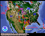
 The screen shot on the right is the overall QPF for the next five days. The left shot is the current NWS warning composite as of Monday morning. That Winter Storm Warning coloration pretty much covers most of the Sierra Mountains. During the next five days, the same area is progged to get almost 3 inches of precip. Meanwhile, the 8-14 forecast shows above normal precip for a wide area of the West.
Our next post will (above) will take a look at the water vapor patterns and the jetstream. The question arising now is "when's the party over?" No pattern persists forever. The first day of Spring is less than five weeks away. In the past few years, the party's ended right about this time of year. In the Good Ol' Daze, March could be a real weather & water producer. Will the good times keep rolling right into March? Fourteen days puts us into early March!


No comments:
Post a Comment