


This story was posted late 27DEC by United Press International:
SILVERTON, Colo., Dec. 27 (UPI) -- This week's winter storm that brought blizzards to the U.S. mountain West dumped 4 feet of snow on high-altitude Silverton, Colo., officials said.
The small town high in the San Juan Mountains took the brunt of the Christmas Day storm as ferocious winds whipped the snow into 8-foot drifts, The Denver Post reported Saturday.
"They got the brunt of it," National Weather Service meteorologist Bryon Lawrence told the newspaper.
The storm closed Molas, Coal Bank and Red Mountain passes, boxing Silverton in and closing the town's two ski areas. But officials said the resorts would likely reopen as soon as the roads were plowed, with the Silverton Mountain Ski Area expected to boast a record-breaking 200 inches of snow -- or 16.6 feet, the Post said.
"The roads being closed has been challenging," ski area spokeswoman Jen Brill told the Rocky Mountain News. "But I never will say that there's any such thing as too much snow. You won't hear that out of my mouth."
There's a lengthier version of this story here in the Denver Post.
December 27, 2008
Batter Up!

Well, let's take a break from all the action here in the Lower 48 and take a trip to the Russian outback. I've tinkered with some graphics here to show you the totally weirdo jetstream coupled with an equally weirdo wad of water vapor. This is a very unusual pattern, folks. I'm not sure how this one will play out as I can't recall ever seeing such a strange pattern before. It looks unusually wet, quite large and possibly ready to set up a very cold snowy pipeline out of Alaska. Weird things like this often change as quickly as they appear so I won't worry too much about it right now. It's kind of like having a rattlesnake along your far back fence. As long as the snake stays out there, no one's too worried. It's only when the snake comes onto your patio that you call Pa-Pa for the shotgun. If there was ever a coiled snake pattern sitting out along the back fence of the Russian regions of Siberian--this is it!
Upper Snake smiling
If a watershed could smile, we suspect the Upper Snake is smiling today. The Camp Springs, Maryland, weather wonks have this to say: "3-DAY SNOWFALL TOTALS OF 2-3 FEET ARE PROJECTED ACROSS THE CASCADES OF WASHINGTON...MOST OF NORTHERN IDAHO...EXTREME NORTHWEST MONTANA AND THE TETONS..." Pocatello NWS 2 pn 27DEC AFD says "SEEMINGLY ENDLESS STREAM OF PACIFIC MOISTURE IS POURING INTO THE REGION." The QPF graphs shows a direct hit on Y-stone and the Tetons. This is real good news for Tater Nation as the NRCS says the Upper Snake only needs a 90% snowpack to have adequate irrigation for the 2009 growing season. If the latest forecast comes true, Tater Nation's ruler King Tot will throw a New Year's party!

Meanwhile, check the 27DEC warning mosaic in the Midwest. It's hard to remember a weirder grouping of warnings all bunched together. You've got a tornado watch, a flash flood warning, an ice storm warning and even a red flag warning way down south. What an eclectic mix of watches and warnings!
Meanwhile, parts of the PAC NW coast are indeed getting some decent rainfall. NW Oregon is under a flood warning so we will probably have some media coverage of the results here pretty soon. Stay tuned.
December 26, 2008
Polar Crown Prominence
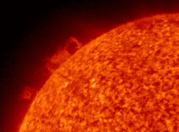
Here's a real "dousey," as Ned Ryerson would say in Ground Hog Day. If you go to Spaceweather, you can read all about it. Meanwhile, I figured I'd post it here because it's so danged beautiful and mysterious and even a wee bit Gothic.
When it rains it pours

Above is the precip prediction mosaic for the lower 48. Pretty danged impressive precip figures progged out on the coast and up in the Idaho Panhandle. If these figs come to pass, somebody, someplace is somehow gonna be in a world o' hurt! (NOTE: We liked this graphic so much we found its source and made it a permanent part of our links at left.)
 When these big Pacific storms roll ashore and dumpall their water on the windward side of the Cascade Range, it always reminds me of a huge bomber hugging the deck and speeding toward its destructive destiny. These types of storms are so awesome and magnificent. I try to imagine the sheer weight of the water in the sky. All weather is wonderful but winter weather is even more so!
December 25, 2008
Snow snippets
(Edited 27DEC) We roamed El Net on Christmas looking for "snow snippets."
We continue to look for little gems. on 27DEC we found this in a editorial by the Portland Oregonian newspaper: "...a storm rated as the region's worst in 40 years." The Portland NWS verifies this here.
The snippets below were the ones found on Christmas Day.
Here's a few we found in one single AP article:
"A blizzard warning for the San Juan mountains in southwest Colorado warned that as much as 3 feet of snow was possible."
"About 2 feet of snow fell overnight in the mountains around Lake Tahoe, bringing totals at some resorts in the past two weeks to 10 feet."
"Up to 18 inches of snow was possible in the Cascades; in the eastern half of the state Spokane, expected 5 to 7 inches of new snow atop a heavy layer that accumulated during weeks of storms."
From a a different source comes this gem:
"In Canada, meteorologists are predicting the first coast-to-coast white Christmas since 1971."
From Wisconsin media we learn:
"Wednesday's 2.9 inches of snow in Madison pushed the December total to 36.1 inches, breaking the December record of 35 inches set in 2000, the National Weather Service reported. The normal December total is 9.1 inches and last December's total was 26.4.
It also pushed the calendar year 2008 total to 106.8 inches, far above the old record of 82.6 inches in 1994.
The lone remaining record standing is the all-time monthly total of 37 inches set in February 1994.
And this from an agricultural publication:
"The snow depth at Claifornia's Big Bear Lake climbed to 54 inches. Big Bear Lake's greatest snow depth on record was 58 inches on February 3, 1979."
Red is a rare color

Yep, red's a rare color on these here maps. Red is the appropriate color for a blizzard warning. You might call it Code Red. All kidding aside, red is not a good color to see on a NWS warning map. It means people who are out in those conditions are facing very dire straits. Our prayers go out to those who are traveling Code Red areas on Christmas Day. (Click the little picture to see the full size version.)
Frisky forecasters
Once in awhile the normally dour NWS forecasters kick up their heels and add itty-bitty little personal comments in the AFD's. ANd so it is today--Christmas Day--that the Pokie-Mon (That's our private term for Pocatello NWS Forecasters) added the nifty little header the 3 am AFD:
WELCOME TO THE CHRISTMAS 2008 WINTER STORM FOR EASTERN IDAHO. A VERY COMPLEX AND DANGEROUS SITUATION HAS DEVELOPED ACROSS SOUTHERN AREAS. CURRENT SATELLITE AND RADAR SHOW PLENTY OF SNOW ACROSS THE AREA. ADDRESSING WIND AND HEAVY SNOW FIRST...BLIZZARD CONDITIONS HAVE DEVELOPED ACROSS PORTIONS OF THE MAGIC VALLEY AND SNAKE RIVER PLAIN. WIND GUSTS OF 50 TO 60 MPH ARE COMMON AT 245 AM IN FROM AROUND FT HALL TO POCATELLO TO WEST TO BURLEY AND ACROSS THE SOUTHERN HIGHLANDS. THE STRONGER WINDS ARE NOW BEGINNING TO SPREAD FARTHER NORTH INTO THE SNAKE PLAIN. THESE AREAS WILL CONTINUE TO SEE VERY STRONG WINDS UNTIL LATER IN THE AFTERNOON AS THE FRONT PASSES THROUGH THE AREA. FOR THE REST OF EASTERN IDAHO...SNOW AND GUSTY WINDS WILL CREATE HAZARDOUS DRIVING CONDITIONS AS WELL THROUGH TONIGHT. SNOWFALL TOTALS THROUGH 5PM TODAY ARE GENERALLY 5 TO 10 INCHES WITH HIGHER AMOUNTS IN THE SNAKE RIVER PLAIN. FOR THE CENTRAL MOUNTAINS ARE 4 TO 8 INCHES WITH UP TO 10 INCHES ON THE PEAKS IN THE LOST RIVER/PAHSIMEROI REGION...THE REST OF THAT AREA WILL SEE 9 TO 12 INCHES IN THE VALLEYS WITH UP TO 2 FEET IN THE SAWTOOTHS. OUR OTHER MOUNTAINOUS AREAS WILL SEE 8 TO 13 INCHES IN THE VALLEYS WITH UP TO 2 FEET IN THE IDAHO WASATCH. THE EXCEPTION WILL BE THE SOUTH CENTRAL HIGHLANDS WHERE 5 TO 10 INCHES TOTAL IS FORECAST.
WELCOME TO THE CHRISTMAS 2008 WINTER STORM FOR EASTERN IDAHO. A VERY COMPLEX AND DANGEROUS SITUATION HAS DEVELOPED ACROSS SOUTHERN AREAS. CURRENT SATELLITE AND RADAR SHOW PLENTY OF SNOW ACROSS THE AREA. ADDRESSING WIND AND HEAVY SNOW FIRST...BLIZZARD CONDITIONS HAVE DEVELOPED ACROSS PORTIONS OF THE MAGIC VALLEY AND SNAKE RIVER PLAIN. WIND GUSTS OF 50 TO 60 MPH ARE COMMON AT 245 AM IN FROM AROUND FT HALL TO POCATELLO TO WEST TO BURLEY AND ACROSS THE SOUTHERN HIGHLANDS. THE STRONGER WINDS ARE NOW BEGINNING TO SPREAD FARTHER NORTH INTO THE SNAKE PLAIN. THESE AREAS WILL CONTINUE TO SEE VERY STRONG WINDS UNTIL LATER IN THE AFTERNOON AS THE FRONT PASSES THROUGH THE AREA. FOR THE REST OF EASTERN IDAHO...SNOW AND GUSTY WINDS WILL CREATE HAZARDOUS DRIVING CONDITIONS AS WELL THROUGH TONIGHT. SNOWFALL TOTALS THROUGH 5PM TODAY ARE GENERALLY 5 TO 10 INCHES WITH HIGHER AMOUNTS IN THE SNAKE RIVER PLAIN. FOR THE CENTRAL MOUNTAINS ARE 4 TO 8 INCHES WITH UP TO 10 INCHES ON THE PEAKS IN THE LOST RIVER/PAHSIMEROI REGION...THE REST OF THAT AREA WILL SEE 9 TO 12 INCHES IN THE VALLEYS WITH UP TO 2 FEET IN THE SAWTOOTHS. OUR OTHER MOUNTAINOUS AREAS WILL SEE 8 TO 13 INCHES IN THE VALLEYS WITH UP TO 2 FEET IN THE IDAHO WASATCH. THE EXCEPTION WILL BE THE SOUTH CENTRAL HIGHLANDS WHERE 5 TO 10 INCHES TOTAL IS FORECAST.
Washington Emergency
On Christmas Eve, Washington State Gov. Chris Gregoire proclaimed a state of emergency due to the weather and storms across the state.
"Snowfall has reached record or near-record level in 30 of the state's 39 counties," Gregoire said in a statement. "Many communities, especially in eastern Washington, are expecting as much as a foot or more of additional snow this holiday weekend.
"This proclamation will enable the state to respond quickly to local requests for emergency support and assistance arising from these new storms."
Things could go from real bad to really terrible for Washington State. Oregon is looking at 2-3 inches of rainfall over the weekend--with the snow level ABOVE the pass levels! WOW--that could cause real headline floods throughout the Oregon. I'd reckon Washington could be in line for some of the same. OUCH!
Here's The Portland Christmas discussion:
WHAT IS BECOMING MORE CLEAR HOWEVER IS THAT THE PRECIPITATION AMOUNTS THE COAST RANGE AND CASCADES ARE LIKELY TO RECEIVE WILL BE RATHER HIGH. MODELS SHOW EXTENDED PERIODS OF 20-40KT OF WESTERLY MID LEVEL FLOW FROM SATURDAY AFTERNOON THROUGH TUESDAY. RIGHTFULLY SO...MODELS SHOW UPWARDS OF 2 TO 3 INCHES OF QPF DURING THIS TIME PERIOD. THE RAIN/SNOW LINE SHOULD BE ABOVE PASS LEVELS THIS WEEKEND AND EARLY NEXT WEEK...SO LOW LEVEL SNOW WILL NOT BE AN ISSUE. HOWEVER...THE SKI RESORTS COULD END UP WITH A SIGNIFICANT AMOUNT OF SNOW...POSSIBLY 2-3 FEET.
December 24, 2008
Moderately major

Here's the Western USA NWS mosaic of various warnings, watches and what not. Most of the Pacific NW and what some people call tine "Inland Northwest" is blanketed by winter storm warnings and watches. Snow is progged to start today over most of this area and then gain momentum during the night and on Christmas Day. Idaho Falls is progged to get anywhere from 4-8 inches total during that 36-hour time frame.
Meanwhile, there's some ominous chunks of water vapor gathering steam out in the Pacific. They are moving this way pretty fast, too. It's a long read but check out the 3 am Portland NWS Discussion for 24DEC.
.LONG TERM...NO CHANGES. PREVIOUS DISCUSSION FOLLOWS...AVAILABLE GUIDANCE ALL SEEMS TO POINT TO A VERY WET AND ACTIVE EXTENDED FORECAST. STRATIFORM RAIN WILL SPREAD ACROSS THE AREA ON FRIDAY AFTERNOON AND EVENING AS A PACIFIC SYSTEM MAKES LANDFALL NORTH OF VANCOUVER ISLAND. THIS SYSTEM OPENS UP ZONAL FLOW THAT STRETCHES INTO THE PACIFIC NORTHWEST FROM WELL PAST THE ALEUTIAN CHAIN. WITH SUCH A FAST FLOW ACROSS THE PACIFIC...AND SEVERAL EMBEDDED SYSTEMS FORECAST TO MOVE THROUGH THE DISTRICT FROM SATURDAY ONWARD...KEPT LIKELY POPS IN THE LOWLANDS AND CATEGORICAL POPS ALONG THE COAST AND COAST RANGE AS WELL AS IN THE CASCADES FOR THE ENTIRE EXTENDED TIME FRAME. ADDITIONALLY...WESTERLY H85 FLOW OF +30KT IS FORECAST FROM SATURDAY MORNING ONWARD...WITH FREEZING LEVELS BETWEEN 3500-5000 FEET. WITH SUCH FAVORABLE OROGRAPHIC FLOW AND MODEL QPF VALUES OF 2-3 INCHES DURING THIS TIME PERIOD...A SIGNIFICANT AND PROLONGED PERIOD OF MOUNTAIN SNOW SEEMS LIKELY...LIKELY IN EXCESS OF 3 FT IF FREEZING LEVELS STAY AROUND OR BELOW PASS LEVELS. DALTON
December 23, 2008
White Christmas

Ain't that a purty Pacific picture? The curly-cues that have been forming out in the Deep Pacific this winter have been downright artistic! The little wad of water vapor you see in the Pac NW is due to arrive in SE Idaho on Christmas, virtually guaranteeing a White Christmas. It won't produce much accumulation--just a lot of big, fat flakes in the cold, crisp air.
However, Loyal Readers, we wish to call your attention to that huge chuck of water vapor visible on the far left of the above picture. (roughly 190W 45N) Now THAT is something! If that blob can retain its integrity by the time it washes ashore over here, may have to call Houston and report that we have a problem.
Well, I promise to tidy up this blog on Christmas Eve--I've let it slide for awhile. We've had some decent snow in Idaho Falls (KIDA). I've been walking to work each day because it's too messy to drive. As Tim McGraw would say, "I like it, I love it, and I want some more of it!"
Subscribe to:
Comments (Atom)