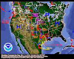
 Don't ya love those pretty colors? Well, they do tell a story. Take a Big Picture look at the advance of warmer temps coming in from west-to-east all up and down the Pacific Coastline. These are generally the overnight temps depicted here. Those warmer temps are progged to march right into Eastern Idaho today, tonight and tomorrow. Since they will be accompanied with ample moisture, we are looking at a rain event taking shape here.
So far, it doesn't appear to be enough rain to raise the flood flags, but it's sure going to be interesting to see how it shapes up and progresses through the region.
I'd suspect this event will put a serious dent in the low elevation snow and usher in the infamous "Mud Season" in one fell swoop. I put this surface temp graphic up here this morning because I think it's the key indicator for the next couple of days. Keep an eye on the progression and evolution of surface temps to get a good idea how the Intermountain West will be affected by the incoming Pacific precipitation.


1 comment:
John
I am so excited to have you as a reader. Your comment was truly one of the nicest I have ever read, if I had a book I would put it on the back cover ;)
Erma Bombeck was one of a kind and I was the only 9 year old I knew who read all her books avidly :D I have loved her for about as long as I was able to read in fact.
I am intrigued by your blog. I used to live in Eastern Idaho and the winters were brutal, they make the Old Man Winter Ohio style look like a pansy.
What is your occupation? I see you list volunteer work, is it meterological in nature?
Thanks again for taking the time to read and leave such a thoughtful and kind comment, I really appreciate it and it makes me happy that my blog brightened someone's day! I hope to get to know you better!
Post a Comment