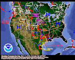
 Anyone who knows me knows that the word "jetstream" is a fundamental part of my regular vocabulary. I don't use the word "jetstream" as often as "food" but it's close! The above jetstream composite forecast clearly shows some impending weirdness along the California Coast. This nicely done graphic can be found here.
Our "goto" image of the jetstream is linked from the graphic in the column at left. There's a pretty weird kink in the jet out there today. If it got any kinkier, it would probably just disappear. I clipped a visual snippet of it. You can click on the tiny graphic to see a larger screen shot.

In case you need a tutorial on the jetstream, Wikipedia, of course, has a most excellent discussion.
I highly advise anyone who's truly interested in our weather patterns to "become one" with the jetstream. Watch it. Learn it. Anticipate it. Enjoy it!
PS--The Good Ol' NWS runs a great online "weather school" appropriately dubbed "Jetstream." If you have ample spare time, I suspect you'd enjoy this school.
It's abundantly clear that the jetstream patterns you see in this blog post are going to very soon "deliver the goods." Click on the QPF link at left and check the 5-day graph.
"Are you ready for some SNOWFALL?"
(This phrase is to be shouted with the same cadence, volume and enthusiasm as the opening line to Monday Night Football.)
(This phrase is to be shouted with the same cadence, volume and enthusiasm as the opening line to Monday Night Football.)


No comments:
Post a Comment