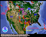
Looks like our mid-winter break is finally coming to an end. Here's a Wednesday morning Pocatello AFD snippet:
.SHORT TERM...TODAY THROUGH FRIDAY NIGHT. UPPER RIDGE AXIS CONTINUES TO SHIFT EASTWARD THIS MORNING AND IS PROGRESSING INTO WESTERN WYOMING. A MULTI-FACETED PACIFIC SYSTEM WILL MOVE ON SHORE TODAY WITH SEVERAL DISTINCT AREAS OF CIRCULATION. SATELLITE IMAGES DEPICT A CIRCULATION WEST OF LOS ANGELES WHILE A SECOND AND THIRD MORE POTENT SYSTEM WEST LIES WEST OF VANCOUVER ISLAND AND IN THE NORTHEASTERN GULF OF ALASKA...
As you can see from the above graphic, your friendly NWS weather wonks are showing some medium decent precip over the next five days. Let's hope they are correct.
The Idaho-Wyoming snowpack has held up well during this protracted high pressure system. Island Park still has about 3 feet. Two Ocean Plateau in Wyoming is a whisker short of 6 feet. Snow water equivalent has held steady. Most watersheds are at or above 100% of normal for this time of year. One more big round of snowstorms would put every drainage in great shape for spring. With any luck at all, we hope to see February deliver one or two more feet of snow across the Intermountain West.


No comments:
Post a Comment