


It's that time once again for another stirring SUNDAY SCHOOL! Yea, yippee, aren't you excited? So grab your mouse and click it up a notch!
Back during our last Sunday School, January 25 we theorized that La Nina was a "happening reality." Lo and behold, the very next day--January 26-- NOAA & NWS jumped on the La Nina bandwagon. The full story is told in a 30-page document that insanely heavy on jargon, numbers, charts, graphs and lots of little arrows and squiggly lines. If you can hack looking at this mind-numbing piece of science it's located here. We will expand and expound more on this topic later. It's Sunday morning and I need more coffee.
Here's a real fun gift received in this morning's email inbox. It's a perfect little ditty for this morning's weekly Sunday School. One of our Dear Readers and Followers found a 1985 media clipping about some guy who studied weather proverbs such as: “The squeak of the snow will the temperature show.” Thanks to Stephen N. (AKA Stephen S.) we now have these gems preserved for posterity a click over right yonder on our website.
Speaking of Sunday School, it's time for a pop quiz! OK, Class, what, where and when were the most extreme high and low temps recorded for Idaho? Or Arizona? Or whatever? I can hear your groans, class, and I feel your pain. But, trust me, these are trivia well worth remembering. Imagine the bets you can win!
For the record, Idaho's highest temp ever recorded was 118 in Orofino in 1934 and it's lowest was 60 below at Island Park Dam in 1943. Click here to see every stat's extremes and scroll down the page for the actual data.
How's the Sea Ice doing? Not to fear, Class, simply click here.
Class, this is a great one!!!! I'm sure you've been reading that Redoubt ash caused engine failure on a jetliner back in 1989. Well, I've been having trouble finding the details of the story. I finally found them this morning in Russia at KVERT--Russia's science center for watching volcanic activity on the Kamchatka Peninsula.
If you thought those people who surfed down onto the Hudson were worried, imagine what it would be like to free fall 18000 feet with NO engines on a 747 jetliner. Now, we're talking a real "life passing in front of your eyes" experience. Here's the details--it's an amazing story--WOW:
"On December 15, 1989, a Boeing-747 flying from Amsterdam with 231 passengers and 13 crewmen on board started to descend from the cruising altitude in order to land in Anchorage, Alaska, USA. The plane was at a height of 7500 m, and was flying a distance of 240 km from Redoubt volcano, when suddenly it entered an ash cloud from a volcanic eruption. As a result, all four engines died. After eight minutes, and with only 2000 m to land, the pilots finally were able to restart the engines. After the aircraft landed, over 60 kg of volcanic ash was removed from each turbine-engine. All four engines, as well as the navigation system, and electric system had to be completely replaced. The loss to the airline due to this incident was over 80 million dollars."
Talk about pucker factor! By the way, I do a redoubt Rewrite at least twice daily. I added some new links this morning. Check it out. This concludes Sunday School. Now GO PLAY!
February 1, 2009

January 30, 2009
Not so California Dreamin'
 In spite of the copious gifts of The Great Winter 2008-2009, California has been left out. They are in a "world of hurt" right now waterwise. It looks real grim for California. So grim, in fact, we won't even attempt to make jokes or puns about it. Click here to read just how grim it really is. Grim is the word of the day there. Grim & bear it.
(Added 01FEB-Edited 02FEB)If you click on the QPF link at left, you will see the 5-day shows California getting some precip. A little more than 1 inch of water is progged for parts of the Coast Range. Water falling in the Coast Range doesn't help much. The Climate Prediction Center's 6-10 forecast confirms the QPF projections. Don't forget to check the CPC's website at least once a week.
What's on tap?
 It's time to talk about what might be upstream heading our way. The high pressure over the West doesn't seem to be as strong or persistent as January's earlier mid-winter break. I'd suspect this high will move east soon. Meanwhile, another good pattern is shaping up for possible transport of lots of water onshore. The equatorial latitudes are beaming up a real nice plume on the "southern track." Siberian is also doing its duty and pipelining a rather consistent looking plume on the far northern track. Meanwhile the middle track looks like it's setting up a shipment, too. In football this might be called "the West Coast Offense." I'd suspect that one or more of these vapor plumes will be making news sometime next week.
January 29, 2009
When in doubt-Redoubt!

(Edit #5 31JAN09 8:30 pm)You are all up to speed on Mount Redoubt--no doubt! It's going to blow. It's not a matter of if, simply when.
In the meantime, perhaps this would be a good time to review "volcanic lightning. Yep, there really IS such a thing! Google it and then select "images." The above image is that Big Volcano in Chile whose name I can never spell or pronounce. From what I've been reading, it's a major motion picture show!
OK, back to Redoubt. In case, you've been sleeping under a basalt rock, Redoubt's a big volcano 100 miles upwind from Anchorage. It's last eruption gig spanned from December 1989 to April 1990. It also erupted in 1966 and 1902. This particular volcano has the potential to really shake up North American weather patterns.
A Google News search using simply the word "Redoubt" will yield hundreds of articles.
Here's a pretty cool article from late Saturday evening.In a column called "Talk of the Tundra," a writer lists a long bibliography about Redoubt.
The northern latitudes are already still filled up with a major dose of volcanic gas from the 3 Aleutian volcanic eruptions this summer. All that gunk is still up there. That's the primary reason it's been so much colder than normal up there this winter. Here's a nice NASA link on volcanic cooling. The Alaskan Volcano Observatory is taking this event very seriously. As of Friday morning the AVO's web servers were totally overwhelmed and the site was inaccessible. As of Saturday morning AVO was back online and fully functional.
I've been reading about Redoubt's impact on the Cook Inlet oil facilities back in 1989-1990. Get this: at it's peak flow, the Drift River was running 2.1-MILLION cfs! That is more than the Mississippi. Here's where I read those figures.
January 28, 2009
A Mild Future is in Store

It looks like we are in for a mild future. Not a Bluebird phase, perhaps, but at least a pause from the mayhem of recent daze. We've been pretty battered here lately by snow and cold. Susun and I joked today that driving the local streets felt like four wheeling in Custer County! Of course, we don't have a four wheeler here and we're driving on summertime tires. So take our assessment with a grain of snow.
As you can see by Thursday's 5-day QPF forecast, it looks totally dry across the West. Perhaps the Tetons will get a few more inches of snow. These same QPF graphs from a few days ago sure turned out to be spot on.
Idaho Falls is definitely "under the spell" of winter. Whatever you do here, where ever you go, you are aware that the slightest slip up will result in a jarring fall on ice-covered concrete or asphalt. This morning I wore Yak-Trax on my boots when I snowblowed the sidewalks. People we know here are walking very carefully each with each step--they know the cost of a slip up. Yea, verily, this is what it means to have an "epic winter." We're not complaining--it's a good thing!
January 27, 2009
Happy Trails, Frank!
One of our dear friends, Frank Protiva, was killed last Friday morning when his 1963 Cessna 205 crashed in trees about 15 miles south of Flagstaff, Arizona. Frank was one of the 5 "Followers" of this Blog. He was an avid weather watcher and we exchanged many great emails about "The Great Winter of 2008-2009." You can click on his picture at left to read his official obituary. I will be creating a memorial page for him on my personal website. Since we was a genuine Follower of this blog, I thought it was only fitting that he should have a little memorial here, too. NOTE: When this post moved off the front page, we took down Frank's photo and the link connected to it. It's going to take us at least a day to reconnect the photo, the post and the link to his obit. Don't worry, it's on our radar. Thanks for your patience. j
Kinda cold here

Surprise! The overnight low here in Idaho falls reached 29 below. Clouds moved in and as of dawn the temps had rallied to only maybe 8-10 below. Click here to see the blow-by-blow data.
January 26, 2009
Fireball
You may have read about the fireball in Sweden about mid-month. I know it's not really related to winter weather here but I'd like to preserve the best known video of the fireball for posterity.
January 25, 2009
Los Niños
 It's Sunday School! Yippee! OK, Welcome to Sunday School. Today we're going to talk about a couple of Golden Oldies: El Niño & La Niña, AKA Los Niños. You've all heard their names a thousand times since they were "discovered" back in the 1980's. The books, papers and articles written about Los Niños would probably fill a skyscraper.
As the years have passed, Los Niños have become a legendary part of global weather lore. It's been a long time since I've seen a simplified explanation of those two terrible children. Well, lo and behold, while we were roaming El Net this morning we quite literally stumbled onto a very nice and simple description and discussion of Los Niños. Click here to go to the NWS Pacific Regional HQ's "ENSO" page. Then click the "Next" button at the bottom of that page, and viola, Sunday School comes alive!
 OK, Class, we'd like to call your attention to something called the "Niño 3.4 Zone." Click on the tiny graphic here and you will see it between latitudes 5N and 5S and between longitudes 120 and 150 West. The NWS says this zone "is the preferred region to monitor sea surface temperature" for the purposes of monitoring ENSO and therefore Los Niños. Now, Class, go click over on the SST link at your left. Take a real close look at the Niño 3.4 Zone and tell me what you see. Hum...that's right, Class, you see cooler waters! NOAA & the NWS have this little gig where they won't declare either an El Niño or La Niña until they have months of data to back up their claims. Often, I've noticed that either of the Los Niños is clearly visible long BEFORE the scientists say it's "official." I am getting an inkling that such may be the case right now. I've heard vague rumors that a "weak La Niña" is possible for this year. (Check this Anchorage article.) I'm beginning to think those rumors might worth listening to. Keep an eye on the Niña 3.4 Zone in the weeks ahead. If you see a wider area of cooler water and a cooling trend, I think you might wanna lend some credence to those rumors! Thanks for attending Sunday School. Now GO PLAY! (PS--We are now moderating comments so there will be a time delay between when you comment and when it shows up. Sorry 'bout that!)
YMMV
 YMMV is texter-talk for "Your Mileage May Vary." It's relevant today in context of recent snowfall. Precip has been pretty fickle in Eastern Idaho. Island Park barely picked up a half inch of precip and only a few inches of snow. Meanwhile Pine Creek Pass fared better, gaining about 10 inches of snow. The real winner is down in Napoleon Dynamite Country in the high country of the Idaho Wasatch east of Preston. That area got 2.5 inches of snow water equivalent and danged near another couple of feet of snow! Sunday morning here in Idaho Falls is fully decked in stylish Winter Gray. It's foggy and cold with lots of sloppy snow strewn helter skelter every which way but loose.
OK, let's talk about the graphic in this post. When's the last time you've seen such a "busy" weather map? Looks like they almost ran out of space to draw their little arrows and make those funky circles for heavy snow. I often wonder if making those maps is like playing a video game like Guitar Hero or Grand Theft Auto. Maybe when those head-phone clad Weather Wonks are hunched in front of their computer screen, they are actually rocking out to Def Leppard or grooving on Squirrel Nut Zippers. Who knows?
January 24, 2009
Rain on The Plain In Spain
 News readers are well aware of a terrific storm smacking Southern France and Northern Spain. It's deadly and numerous people have been killed. Officials are calling it the worst such storm in December 1999. Here is one key snippet from BBC: "The storm system has been gathering strength over the past few days as it moved over the relatively warm waters of the western Atlantic." As you can see from the lower graphic, there is a very warm area out in the middle of the Atlantic. This area is almost a mirror image of a similar warm area off our West Coast out in the Pacific.
These types of concentrated areas of abnormal Sea Surface Temperature (SST) warmth can have a great impact on weather systems. Not every system will be impacted. But you can easily see how the current mayhem in Spain has been exacerbated by that warm area in the Atlantic.
I bring all of this up as a caveat--the very same thing could indeed happen with one of the remaining systems due to wash ashore in our neck of the woods. It's fairly unlikely, mind you, but it IS a possibility. Keep an eye on those SST's via the link at left. The very same sort of thing could happen to our West Coast that is now happening to Spain.

January 23, 2009
Back In Business
 Here's the "proof of the pudding." You can see the return of the periodic blobs of water vapor rolling out of Asia into the Pacific for their final approach to the North American Continent. Couple this with the wild and crazy rock and roll jetstream and you have a recipe for another real stout round of Ol' Man Winter! We checked the Climate Prediction Center's website just to be sure. Yep, the 8-14 day and the 30 day forecasts both call for "above normal" precip in the PAC NW. (Sorry, Arizona, yer gonna be left off the Party Boat.)
Sneaky Snow Attack
We woke up earlier than normal this morning--4 am. The light seemed to suggest it was after 6 am. HA! It was because of a stealthy snowstorm that arrived after we went to bed last night. Here in Idaho falls, we're looking at about 6 inches of snow--it's the first storm in weeks. (NOTE--Once I got out in it, I'd say it's 8 inches.) It's snowing heavily as I write this so I suspect we will get more of the white stuff. Definitely time to fire up the snowblower.
That high pressure really lulled us into "lah-lah land." It seemed like the sun would shine forever! The KIDA obs say we've rec'd more than a half inch of precip. That would be consistent with the old-fashioned 12:1 snow to water ratio. Interestingly, the boyz and ghurlz working the night shift at Pocatello NWS must be asleep at the switch. The warning map shows nothing to indicate the area just got whacked by snow. Go figure.
That high pressure really lulled us into "lah-lah land." It seemed like the sun would shine forever! The KIDA obs say we've rec'd more than a half inch of precip. That would be consistent with the old-fashioned 12:1 snow to water ratio. Interestingly, the boyz and ghurlz working the night shift at Pocatello NWS must be asleep at the switch. The warning map shows nothing to indicate the area just got whacked by snow. Go figure.
January 22, 2009
Jet On Meth
 Study this jetstream graphic closely. Click on it for the larger version. There are some really wild kinks and twists and turns on this jetstream. Heck, there's almost the equivalent of an "abandoned meander," in river runner terms. Look over around the UK and check out that little dipsy-doodle.
 This jetstream patterns is beginning to show what we really, really hope to see--CRAZY BEHAVIOR! A crazy jetstream is a good jetstream--at least if you hope to have a wild and wooly winter with lots and lots of cold and snow. A zonal, lazy jetstream is not only boring, it rarely produces bizarre weather filled with extremes. CRAZY jets are like a rock and roll band on drugs. (See 1960's Rolling Stones.) CRAZY jets do crazy things.
A NWS Weather wonk once taught me eons ago to imagine a 19th Century wagon wheel balanced atop the North Pole. He said the jet would be the iron rim of the wheel. If things were lazy and boring all the spokes of the wheel would be the same length and the jet would be zonal and just go round and round. However, he said if the spokes go to be different lengths, then the rim would go crazy. That's the pattern we want to see--a wagon wheel gone wild!
The trick is to visualize that the wagon wheel spins round and round on the North Pole axis. Once the spokes get all out of kilter, they simply keep things out of whack all around the whole planet. It certainly looks to me like we're getting into one of those enviable patterns.
I'm tempted to break out into a river runner wild cheer but I am going to save that irrational exuberance until I know for certain that this pattern is indeed delivering the goods. (Note added 6 am 23JAN: Well, it's delivering the goods as of this morning!)
 The QPF numbers are on the rise. Check the difference between yesterday's QPF and today's You will note some very interesting differences. The net numbers have increased. The areas of coverage are larger. Overall, this is a very good trend.
By the way, what does QPF mean? It's "Quantitative Precipitation Forecast." All gubmint lives by acronyms but the weather wonks are especially addicted to acronyms. I'd suspect they sit around in the deep dark of night secretly plotting to convert all known human activity to an acronym!
Despite their penchant for acronyms, the Wonks also enjoy use of an occasional fun word. Check this snippet from today's Reno AFD: "A RELATIVELY NARROW BUT HEAVY BAND OF RAIN IS MOVING SLOWLY ACROSS NORTHERN AND CENTRAL CA THIS MORNING AS AN UPPER TROUGH MAKES ITS WAY ONSHORE. THIS BAND OF HEAVY PRECIP IS BEING FED BY A JUICY SUBTROPICAL CONNECTION OFF THE BAJA COAST."
Juicy, huh? Way cool, Dude!
January 21, 2009
Lee Waves
 This is a picture of some "lee waves" on the east side of the Rocky Mountains near Boulder, Colorado. Click here to read about lee waves. If you are reading this soon after I posted it, please go to Spaceweather and read about this particular photo and gain some additional insight on lee waves. That Spaceweather website is easily the most fascinating day-to-day website I've ever encountered--at least if you're interested in strange weather and space phenomena.
Bye, Bye, High!

Looks like our mid-winter break is finally coming to an end. Here's a Wednesday morning Pocatello AFD snippet:
.SHORT TERM...TODAY THROUGH FRIDAY NIGHT. UPPER RIDGE AXIS CONTINUES TO SHIFT EASTWARD THIS MORNING AND IS PROGRESSING INTO WESTERN WYOMING. A MULTI-FACETED PACIFIC SYSTEM WILL MOVE ON SHORE TODAY WITH SEVERAL DISTINCT AREAS OF CIRCULATION. SATELLITE IMAGES DEPICT A CIRCULATION WEST OF LOS ANGELES WHILE A SECOND AND THIRD MORE POTENT SYSTEM WEST LIES WEST OF VANCOUVER ISLAND AND IN THE NORTHEASTERN GULF OF ALASKA...
As you can see from the above graphic, your friendly NWS weather wonks are showing some medium decent precip over the next five days. Let's hope they are correct.
The Idaho-Wyoming snowpack has held up well during this protracted high pressure system. Island Park still has about 3 feet. Two Ocean Plateau in Wyoming is a whisker short of 6 feet. Snow water equivalent has held steady. Most watersheds are at or above 100% of normal for this time of year. One more big round of snowstorms would put every drainage in great shape for spring. With any luck at all, we hope to see February deliver one or two more feet of snow across the Intermountain West.
January 18, 2009
Out On A Big Limb Here
 OK, we're going out on a Big Limb here and we taking a saw with us. We're cutting the limb behind us! If you've never tried this trick, I highly recommend it. Put yourself someplace where you can't get back--and then cut the limb off. Wow, it's fun!
Anyway, we think the high pressure is dead--toast, DOA, history. Yeah, it's still here--today in Idaho Falls was majestic--surreal, actually. But today was the high water mark of this puppy. It's outta here. So what if the jetstream is bent backwards? So what if chinook winds are toasting Alaska? So what if people think happy times are here again? It's time for change--dramatic change--and change is coming to your local neighborhood theater soon. I'd expect this high and all of its baggage to be out of here within two days, possibly earlier, but no later than mid-week. Then, the zonal jet will come back and kick anatomy. We've been saying the water vapor blobs are stacked up--you can see them above.
The Big Question Mark (no pun intended) is "what's happening to the polar airmass?" If, as we suspect, the polar air is just as cold as it was prior to this high pressure regime, then it will reassert itself very soon. If some voodoo magic made all that cold air disappear, then we will apologize and you can get your money back for reading this blog. (Your check is in the mail! Bailout money, of course.)
But we don't suspect that any kind of known voodoo has made that frigid polar airmass disappear. We suspect it will be back with a real attitude. And we suspect that the snow events of recent weeks will be just a "tune up" for what's in store.
Yeah, this is Big Limb stuff. When you go out on a limb this big and start saying the sky is falling, you've got nothing to gain and everything to lose--credibility-wise. But, hey, if we didn't do it this way, it just wouldn't be any FUN!
Enjoy the outcome & Cheers!
January 16, 2009
A few Friday night thoughts
(See Sunday notes at end of post.)Well, what's in store for our future now that the high pressure is prepping to move east? There's no lack of Wazillas trying to knock down our doors. In fact, it appears that various pulses of water vapor coming out of Siberia are stacked up like airliners in a busy airport landing pattern. Currently the jetstream is largely zonal until its hits the high pressure wall. Once the high departs, the zonal flow will blow straight onshore along the Western US coast. Be sure to click the SST Map (sea Surface Temps) on your left. There's been an interesting anomaly developing in the heart of the Eastern Pacific. Currently, it's core is 2.59 degrees centigrade above normal. Keep an eye on this. Likewise, keep an eye on that east-west area west of South America that appears to be cooling rapidly. It could be a precursor of a weak resurgence of La Niña. It's obviously too early to tell right now but things are cooling down rapidly there. Watch it!
I suspect we haven't seen the last of the impacts of the summertime volcanic ash that's circulating in the Arctic latitudes. Even though it's been "hot" in Alaska lately, there's a lot of cold air om the arctic latitudes--very frigid up there! (See note below.) The winds in the Central Gulf of Alaska are medium stout right now but their are kicking up 18-20 waves. Check good ol' buoy 49001 to see for yourself.
This has been a wonderful mid-winter break--amazing in scope and power. It's ending soon--you can already see the patterns developing for its departure. Enjoy this weekend--get out and do something really unusual for January--because soon it's "back to the future" and the future is Winter! I'd guess we have 4-6 weeks more winter before the seasonal tilt of earth's axis loosens winter's grip on our latitudes.
Personally, I'm expecting another round of medium decent Pacific storms to begin to pulse ashore soon--building in intensity as the jetstream refocuses it's wrath on the western states. It's time to give the Midwest and the East Coast a well-deserved break! It's going to be our turn once again soon.
Well, that's about all I have to say about it tonight. Maybe tomorrow we will have some different thoughts. Thank you for reading and have a great and glorious weekend!
Sunday thoughts: The high is still there, looking perhaps even stronger. Click the Navy water vapor to see for yourself. Despite the warm chinook winds in Alaska, there still has to be some frigid air up in those latitudes. Consider this from Fairbanks: "The temperature never rose above 20 below for 16 straight days from Dec. 27 to Jan. 11. The low temperature was 40 below or colder on 14 of those days."
I suspect we haven't seen the last of the impacts of the summertime volcanic ash that's circulating in the Arctic latitudes. Even though it's been "hot" in Alaska lately, there's a lot of cold air om the arctic latitudes--very frigid up there! (See note below.) The winds in the Central Gulf of Alaska are medium stout right now but their are kicking up 18-20 waves. Check good ol' buoy 49001 to see for yourself.
This has been a wonderful mid-winter break--amazing in scope and power. It's ending soon--you can already see the patterns developing for its departure. Enjoy this weekend--get out and do something really unusual for January--because soon it's "back to the future" and the future is Winter! I'd guess we have 4-6 weeks more winter before the seasonal tilt of earth's axis loosens winter's grip on our latitudes.
Personally, I'm expecting another round of medium decent Pacific storms to begin to pulse ashore soon--building in intensity as the jetstream refocuses it's wrath on the western states. It's time to give the Midwest and the East Coast a well-deserved break! It's going to be our turn once again soon.
Well, that's about all I have to say about it tonight. Maybe tomorrow we will have some different thoughts. Thank you for reading and have a great and glorious weekend!
Sunday thoughts: The high is still there, looking perhaps even stronger. Click the Navy water vapor to see for yourself. Despite the warm chinook winds in Alaska, there still has to be some frigid air up in those latitudes. Consider this from Fairbanks: "The temperature never rose above 20 below for 16 straight days from Dec. 27 to Jan. 11. The low temperature was 40 below or colder on 14 of those days."
Look at Saturday's highs!
 CHECK THIS OUT! The Saturday high temperature near Glacier National Park is progged to be HIGHER that the temps on the Gulf Coast and the Georgia Atlantic Coast! What? Have the Weather Gods lost their minds? This is amazing! (Note added Sunday morning: It was 20 degrees warmers in Anchorage, Alaska, than Alabama!)You can click this sentence to go to the map as it may appear in real time. I grabbed this picture Friday evening. It might be different tomorrow. But the bottom line is that you won't see this again in January--and possibly not in any January again in your entire lifetime!
(Additional Sunday morning note: Turns out the now famous high pressure system pumped a chinook into Alaska and Fairbanks got to 54 degrees! Here's the full story of the Fairbanks high temps records.
January 15, 2009
Wazilla vs. Super High

Ladies & Gentlemen, in this corner we have Wazilla, Conqueror of The West, and in this corner we have Super High--the most powerful January phenomena we've seen along the Coast in many a year. As Wadzilla and Super High come into the Pacific Ring of Fire--watch them collide with the massive force of the juggernauts they are. WOW--what a show they are putting on for you, Ladies & Gentlemen!
Seriously, this is one of the best displays of the "blocking" affect of a strong high pressure system. The water laden low pressure troughs are literally "hitting the wall" on the west edge of this high pressure system. It's really impressive and due to hang around possibly to the middle of next week. Eventually, it will break down and move downstream, dissipating into the data dust bin of climatological history. WHile it's here and strutting its stuff, it sure is an awesome sight to behold. Enjoy!
January 14, 2009
80 degrees @ Monterrey, CA on 13JAN!

Well, I would never make it as TV weather guy--not unless somebody dressed up my maps for me! From the looks of the goofy doodles on the map above, I'd never make it as a graffiti artist either. As you can see a huge chunk of the West is living under the influence of a gigantic high pressure system. This puppy is so big, it's making the jetstream turn almost 90 degrees north and then arch clear up into Alaska before bending back to head into the Midwest. Farther West, way out in the Pacific, there's a lot of high pressure. The big question is whether subsequent pressure areas will come and follow the one we have right now. What's it going to take to break this pattern and send us back to winter weather? Who knows? Right now it looks like we have a planetary scale pattern in place that could dominate Pacific for some time to come.
A LOT of new record high temps were recorded along the California Coast Tuesday. Amazing figures such as 75 degrees at the San Francisco Airport were logged. Records will be broken today, too but values will be a few degrees less. Just trying to imagine 80 degrees at Monterrey in January is truly mind-bending!
Meanwhile, attention is turning the weather for January 20 when Obama will be sworn in. Click here for a great historical look at such days. The Eastern half of the Nation is getting bodyslammed by cold weather. Luckily, it's supposed to ease to 35 degrees in DC by next Tuesday with mostly sunny skies.
January 11, 2009
Say HI to your HIGH!
 Guess who's coming to dinner? He's big, he's coming from California and he's HIGH! Oh, gawd! A few days ago back when we spoofed that snake out in the Pacific, we kinda thought there would be a giant high pressure system taking up residence in the Great Basin and Southwest US. Today, it looks virtually certain that this high pressure will soon move in for a visit. Below are some Sunday morning snippets from various western AFD's. Please take time to note and ponder the comments out of Las Vegas. MOST interesting!
(Pocatello)--BY THURSDAY THE STRONG HIGH PRESSURE RIDGE ALONG THE WEST COAST MOVES INLAND WITH AGREEMENT OF ALL EXTENDED MODELS. THURSDAY THROUGH SATURDAY SHOULD BE SHOWER FREE EVERYWHERE IN SOUTHEAST IDAHO. SOME HIGH CIRRUS CLOUDS CONTINUE TO DRIFT THROUGH. OTHERWISE THE MAIN WEATHER TRENDS WILL BE FOR A WIDER DIURNAL TEMPERATURES SPREAD AND THE POSSIBILITY OF PATCHY FOG UNDER STRONG SUBSIDENCE INVERSION.
(ELKO) SHORT TERM...CURRENTLY HAVE A 595DM RIDGE CENTERED AT ABOUT 300 MILES OFF THE NORTHERN CA COAST...MODELS ARE IN GOOD AGREEMENT THIS MORNING THROUGH NEXT WEEK. HIGH PRESSURE CENTERED NEAR THE CALIFORNIA COAST ON TUESDAY NIGHT WILL BECOME MORE PROGRESSIVE IN THE FOLLOWING DAYS WHILE MAINTAINING STRENGTH.
(LAS VEGAS) LONG TERM...I HAD SOME TIME TONIGHT WITH THE QUIET WX TO LOOK THIS UP BUT FOUND IT INTERESTING...ALL 3 PREVIOUS DECEMBERS WHERE LAS VEGAS HAS SEEN AT LEAST AN INCH OF SNOW FALL WERE FOLLOWED BY A JANUARY WITH EITHER A TRACE OR 0.01 INCH OF LIQUID PRECIPITATION FOR THE MONTH. WHILE ONLY TIME WILL TELL IF THIS JANUARY WILL FOLLOW SUCH AN ANALOGUE THE LATEST LONG RANGE MODELS REMAIN CONSISTENT WITH KEEPING A HIGHLY AMPLIFIED PATTERN LOCKED IN ACROSS THE US THROUGH THE EARLY PART OF NEXT WEEK. A VERY STRONG 500 MB HIGH IS FORECAST TO BUILD INTO NORCAL WEDNESDAY WHILE A DEEP TROUGH PERSISTS IN THE EASTERN US. THIS STRONG RIDGE WILL RESULT IN 700 MB TEMPS OF +4C TO +6C BY THE END OF THIS WEEK WHICH WILL RESULT IN WELL ABOVE NORMAL TEMPS IN THE HIGHER ELEVATIONS...WITH TEMPS IN SOME INSTANCES AS WARM IF NOT WARMER THAN VALLEYS WHERE INVERSIONS WILL LIMIT JUST HOW WARM THINGS GET.
(FLAGSTAFF) BY TUESDAY WE EXPECT A WARMING TREND TO START...WITH HIGH TEMPERATURES 8 TO 10 DEGREES ABOVE SEASONAL NORMALS LASTING THROUGH FRIDAY.
(RENO) HIGH TEMPERATURES WILL REMAIN 8-15 DEGREES ABOVE NORMAL...OR IN THE 50S AT MOST ELEVATIONS THROUGH THE END OF THE WEEK.
January 9, 2009
Attention: AVALANCHE!
 Avalanches are in the news on an almost daily basis. Snow slides are killing people this year and it doesn't seem to matter where they are. One 85-year-old woman near Spokane was killed when snow slid off her roof while she was shoveling snow on her front walk! People are even getting killed "in bounds" at major ski resorts. You have to read this New York Times article on the situation to really appreciate the depth and scope of the situation. Check this snippet: "Two patrollers witnessed the slide and located Mr. Nodine’s beacon within two minutes. They uncovered his head within another six. Patrollers quickly recovered him from a deep, concretelike tomb, but it was too late; he had suffocated."
January 8, 2009
Ah, High Pressure!
Well, I reckon that Snake Bite graphic I put up a few days ago worked out pretty good. There's a Mid Winter Break coming to your local neighborhood motion picture theater real soon. Check this babble from the Pocatello NWS AFD today. (Note: the spelling of the word "chance" is Pocatello's--NOT mine!)
A MAJOR PATTERN CHANCE WILL TAKE PLACE AS THE PATTERN WE SAW EARLIER IN THE FALL WITH A RIDGE ALONG THE COAST AND A TROUGH EAST OF THE ROCKIES RETURNS. LONG TERM...SATURDAY NIGHT THROUGH THURSDAY. LARGE BLOCKING RIDGE OF HIGH PRESSURE WILL BE THE DOMINATING WEATHER FEATURE THROUGH NEXT WEEK. THE BIG QUESTION WILL BE WHERE THE POSITION OF THE RIDGE AXIS LIES IN RELATION TO EASTERN IDAHO. MODELS KEEP THE AXIS JUST OFF THE PACIFIC COAST FOR THE BULK OF LONG TERM AND AS A RESULT...THE BEST MOISTURE AND INSTABILITY MOVING ALONG THE JET WILL REMAIN NORTH AND EAST OF THE FORECAST AREA.
The farther south you get the more enthusiastic the NWS people are about this whole gig. It looks like the Real Deal, as they say. However, as we said in at least one of our previous posts, don't let your guard down--winter ain't gone. Nope, it'll be BAAAACK! And when it comes, it's coming with a real vengeance and an really BAD attitude. Enjoy this Mid-Winter Break--you deserve it!
A MAJOR PATTERN CHANCE WILL TAKE PLACE AS THE PATTERN WE SAW EARLIER IN THE FALL WITH A RIDGE ALONG THE COAST AND A TROUGH EAST OF THE ROCKIES RETURNS. LONG TERM...SATURDAY NIGHT THROUGH THURSDAY. LARGE BLOCKING RIDGE OF HIGH PRESSURE WILL BE THE DOMINATING WEATHER FEATURE THROUGH NEXT WEEK. THE BIG QUESTION WILL BE WHERE THE POSITION OF THE RIDGE AXIS LIES IN RELATION TO EASTERN IDAHO. MODELS KEEP THE AXIS JUST OFF THE PACIFIC COAST FOR THE BULK OF LONG TERM AND AS A RESULT...THE BEST MOISTURE AND INSTABILITY MOVING ALONG THE JET WILL REMAIN NORTH AND EAST OF THE FORECAST AREA.
The farther south you get the more enthusiastic the NWS people are about this whole gig. It looks like the Real Deal, as they say. However, as we said in at least one of our previous posts, don't let your guard down--winter ain't gone. Nope, it'll be BAAAACK! And when it comes, it's coming with a real vengeance and an really BAD attitude. Enjoy this Mid-Winter Break--you deserve it!

Western Washington snowmelt increases
Yesterday things were bad but not so bad. Today things are bad and getting a lot worse. The Seattle NWS has posted a great synopsis of their situation there. It's 8 megs so don't try to download it unless you have a hot rod broadband connection. They have some VERY impressive slides of what is happening there. There are 22 rivers flooding and a few above all time high flows with a few more progged to set new records. The rainfall amounts and rainfall rates are pretty amazing. This is how a Wadzilla behaves when it comes in on a low level bombing run. It just flat carpet bombs a wide swath of landscape--in this case a heavily snow-covered and steep landscape. They are in a world of hurt up there right now and it's rapidly becoming the biggest story so far to come out of The Great Winter of 2008-2009. All we can do from our chair in this theater is sit back and watch in total awe. Good Luck, Western Washington State, our prayers are with you!
January 7, 2009
Even Alaskans say it's COOOOLD!
Well, blog fans, I was roaming El Net tonight and found a fun AP article out of Alaska. Check this snippet: "Johnson lives in Stevens Village, where residents have endured close to two weeks of temperatures pushing 60 below zero." The article goes on to talk about how the temps have been very low throughout Alaska for a very long period of time this year.
Hum....that sure sounds like what you would expect after all that volcanic ash spewed forth from the Aleutians this summer. Well, I guess the chickens are coming home to roost!
I really love this quote: "I've never seen it this cold for this long," he said. "I remember it 70 below one time, but not for a week and a half."
Even people in Anchorage are complaining. They are apparently accustomed to temps in the low single digits this time of year. However, it's been about -20 and they aren't happy. If the volcanic ash is the root cause of this cold regime, guess what? It's going to continue unabated well into spring time, perhaps even next summer.
Meanwhile, each kinky jetstream that dares dip down into the Lower 48 is going to bring abnormally cold air. When these jetstreams happen to collide with your basic Neighborhood Wadzilla coming across the Pacific, then the areas underneath such collisions are going to get some real epic snowfall and the inherent issues that come with such snowfall.
Even though it appears we are due for a mid-winter break since the jetstream is now zonal and a high pressure system is building over the Great Basin and Southwest, the winter is FAR from over. The abnormally cold air mass engulfing Alaska simply isn't going anywhere. It's up there to stay for weeks and most likely months. Why? Because that volcanic ash continues to circle the globe at the Arctic latitudes.
Meanwhile, the water vapor patterns will continue in much the same way as they have so far this winter. It's not a matter of "IF" the Lower 48 will get body slammed again--only a matter of "WHEN!"
Hum....that sure sounds like what you would expect after all that volcanic ash spewed forth from the Aleutians this summer. Well, I guess the chickens are coming home to roost!
I really love this quote: "I've never seen it this cold for this long," he said. "I remember it 70 below one time, but not for a week and a half."
Even people in Anchorage are complaining. They are apparently accustomed to temps in the low single digits this time of year. However, it's been about -20 and they aren't happy. If the volcanic ash is the root cause of this cold regime, guess what? It's going to continue unabated well into spring time, perhaps even next summer.
Meanwhile, each kinky jetstream that dares dip down into the Lower 48 is going to bring abnormally cold air. When these jetstreams happen to collide with your basic Neighborhood Wadzilla coming across the Pacific, then the areas underneath such collisions are going to get some real epic snowfall and the inherent issues that come with such snowfall.
Even though it appears we are due for a mid-winter break since the jetstream is now zonal and a high pressure system is building over the Great Basin and Southwest, the winter is FAR from over. The abnormally cold air mass engulfing Alaska simply isn't going anywhere. It's up there to stay for weeks and most likely months. Why? Because that volcanic ash continues to circle the globe at the Arctic latitudes.
Meanwhile, the water vapor patterns will continue in much the same way as they have so far this winter. It's not a matter of "IF" the Lower 48 will get body slammed again--only a matter of "WHEN!"
Rivers are up in Washington State
(See updated post above) Well, it's been raining over in Washington State. Actually, it's been some pretty heavy and protracted rain. Numerous rivers are at or near flood stage. However, none of them are remotely near their record high flows. Despite the media hysteria, it looks like a fairly normal runoff event. The snow melt is being contained by the stream channels in an orderly manner. I'd guess that during the "funny money" phase of ridiculous mortgages some people built high dollar houses in the flood fringe or even the flood plain. I would reckon these idiots are getting pounded right now. However, all the rest of civil society in Washington State is doing quite well, thank you!
You can watch all of the snow melt and streamflow mayhem, such as it is, unfold by keeping an eye on the USGS Real Time Streamflow numbers. The "GS," as they are called, maintains a real time data table for every state. It's quite an amazing feat. I highly recommend learning how to monitor streamflows in any given state in America.
Click on this sentence to go to the Washington State real time streamflow page. Surf around until you get the hang of it. Look for the little drop down menu window and choose "Peak Streamflow." This will help you understand just how tame today's flows are compared to the wildness of historical flows. Good luck!
You can watch all of the snow melt and streamflow mayhem, such as it is, unfold by keeping an eye on the USGS Real Time Streamflow numbers. The "GS," as they are called, maintains a real time data table for every state. It's quite an amazing feat. I highly recommend learning how to monitor streamflows in any given state in America.
Click on this sentence to go to the Washington State real time streamflow page. Surf around until you get the hang of it. Look for the little drop down menu window and choose "Peak Streamflow." This will help you understand just how tame today's flows are compared to the wildness of historical flows. Good luck!
January 5, 2009
Can you trust a snake?

Anybody who's been anywhere has had at least one encounter with a snake. Coulda been a rattler--coulda been any snake. But, if you're "Snake Savvy," you know what I mean. Can you trust a snake? Well, I reckon it all depends on your point of view. I trust any snake that's outside of my truck!
OK, here we go--check this out. In the photo above this narrative is the latest US Navy water vapor picture out in the Pacific. Sure looks weird to me, I have to admit.
They say--"they" being the weather wonks--that we might be getting a big ol' high pressure system coming to visit. What that means is a "mid-winter break." I kind of think they are right, especially when I'm looking at this snake out in the Pacific.
If the snake coil keeps coilin' and the snake puffs up some more, I'd reckon this here snake could settle over the whole entire Western You-nighted States. It's one big puppy, that's furr shure.
Well, meanwhile, we are getting some annoying skiff of snow here in Idaho Falls--nothing deep enough to do anything with but just deep enough to make idiot drivers make fools of themselves.
January 4, 2009
Ten Below here
The sub-zero cold snap predicted actually materialized and we're sitting Sunday morning in the deep freeze. Actually, ten below ain't bad. What few hardy souls are left in Stanley are really shivering at -28! Temps will probably rise somewhat in the next day or two. We're progged for some snow Monday. The far Pac NW coast is due to get hit hard once again. Check this snippet from the morning Seattle AFD:
RAINFALL AMOUNTS OF 3 TO 6 INCHES IS POSSIBLE ON THE COAST AND IN THE CASCADES DURING THE TUE NIGHT THROUGH WED NIGHT TIME FRAME...WITH 8 TO 12 INCHES POSSIBLE ON THE SW FACING SLOPES OF THE CASCADES. THIS AMOUNT OF RAINFALL WOULD DRIVE MANY AREA RIVERS ABOVE FLOOD STAGE. THIS SITUATION BEARS CLOSE MONITORING.
In reading the various AFD's and looking at global water vapor patterns and the jetstream, I think we're going to get a classic "mid-winter break" beginning sometime around 10JAN, perhaps as late as 12JAN. Even the Climate Prediction Center has both the 6-10 and 8-14 days maps looking good--above normal temps and below normal precip. It's about time!
The key to our winter snowpack will unfold in late January and February. Last year, the snow pretty much stopped in early February. This year, I have a hunch, we might see some additional snow in the mid to late February timeframe. Water supplies are looking pretty good right now but we need to finish the job.
RAINFALL AMOUNTS OF 3 TO 6 INCHES IS POSSIBLE ON THE COAST AND IN THE CASCADES DURING THE TUE NIGHT THROUGH WED NIGHT TIME FRAME...WITH 8 TO 12 INCHES POSSIBLE ON THE SW FACING SLOPES OF THE CASCADES. THIS AMOUNT OF RAINFALL WOULD DRIVE MANY AREA RIVERS ABOVE FLOOD STAGE. THIS SITUATION BEARS CLOSE MONITORING.
In reading the various AFD's and looking at global water vapor patterns and the jetstream, I think we're going to get a classic "mid-winter break" beginning sometime around 10JAN, perhaps as late as 12JAN. Even the Climate Prediction Center has both the 6-10 and 8-14 days maps looking good--above normal temps and below normal precip. It's about time!
The key to our winter snowpack will unfold in late January and February. Last year, the snow pretty much stopped in early February. This year, I have a hunch, we might see some additional snow in the mid to late February timeframe. Water supplies are looking pretty good right now but we need to finish the job.
January 2, 2009
More of the same
A regular series of Pacific storms continue to affect our Northwest weather. The daily QPF graphs look remarkably the same each day. The US Navy water vapor photos also seems to be clones of the previous day. The NWS chatter in their various discussions is sounding like the proverbial old broken vinyl record. Idaho Falls has enjoyed a few days above freezing but it looks like we're in for another cold snap. Here's the AM Pocatello AFD snippets:
LATEST IR SATELLITE SHOT SHOWING CLOUDS AND ASSOCIATED PRECIP DUE TO OVERRUNNING. QUITE UNBELIEVABLE OVERRUNNING IN FACT AS TEMPS THIS MORNING RANGE FROM 44F AT BURLEY...44F AT CHALLIS...AND 34F BEING REPORTED AT STANLEY. SNOWFALL AMOUNTS
EXPECTED TO BE 10 TO 14 INCHES IN SAWTOOTHS WHILE UP TO A FOOT EXPECTED IN EASTERN AND SOUTHERN HIGHLANDS. ANOTHER CONCERN ARE THE WINDS. 120KT JET PROGGED TO MOVE OVER REGION THIS MORNING AND IN RESPONSE...HOWEVER...NOW MUST CONTEND WITH A REMARKABLE TEMPERATURE CHANGE. HI TEMPS ARE EXPECTED TO DROP ROUGHLY 30 DEGREES BY SATURDAY WITH LOWS BELOW ZERO IN MOUNTAINOUS AREAS AND SINGLE DIGITS ACROSS REMAINING REGIONS.
The primary beneficiary of this pattern is the Upper Snake River watershed. It is beginning to look very favorable for the 2009 water supply.
LATEST IR SATELLITE SHOT SHOWING CLOUDS AND ASSOCIATED PRECIP DUE TO OVERRUNNING. QUITE UNBELIEVABLE OVERRUNNING IN FACT AS TEMPS THIS MORNING RANGE FROM 44F AT BURLEY...44F AT CHALLIS...AND 34F BEING REPORTED AT STANLEY. SNOWFALL AMOUNTS
EXPECTED TO BE 10 TO 14 INCHES IN SAWTOOTHS WHILE UP TO A FOOT EXPECTED IN EASTERN AND SOUTHERN HIGHLANDS. ANOTHER CONCERN ARE THE WINDS. 120KT JET PROGGED TO MOVE OVER REGION THIS MORNING AND IN RESPONSE...HOWEVER...NOW MUST CONTEND WITH A REMARKABLE TEMPERATURE CHANGE. HI TEMPS ARE EXPECTED TO DROP ROUGHLY 30 DEGREES BY SATURDAY WITH LOWS BELOW ZERO IN MOUNTAINOUS AREAS AND SINGLE DIGITS ACROSS REMAINING REGIONS.
The primary beneficiary of this pattern is the Upper Snake River watershed. It is beginning to look very favorable for the 2009 water supply.
December 30, 2008
Deja vu?
Phil: Do you ever have deja vu Mrs. Lancaster?
Mrs. Lancaster: I don't think so, but I could check with the kitchen.
Above is one of my favorite quotes from the movie Ground Hog Day. Bill Murray is in the dining room of his B&B. Well, in this case our weather deja vu is all coming from the same kitchen right now--Siberia. Big Wadzillas there are ganging up and rolling offshore to bluster across the Pacific and splatter the Northwest with fat gobs of rain, ice and snow. The pattern looks to continued abated for awhile. Today's QPF graphic looks almost exactly like one from a few days ago. Deja Vu? You betcha!
Meanwhile, one of the Jackson ski resort restaurants sustained avalanche damage yesterday. It was a front page story in the Idaho Falls paper. They claim to have rec'd 5 feet of snow in 7 days. Avalanche deaths are soaring, 9 since 14DEC, plus another 8 in Canada over the weekend.
The jetstream has gone zonal--basically that means Old Man Winter is blowing full force in a straight line right smack across the Pacific. No dipsy-doodle whippy kinks and bends for the jetstream right now. Don't worry, though, they will be back!

People really begin to pay attention to the gubmint's snow data as of 01JAN each year. That's the first report that really matters. The US NRCS will publish monthly Snow Reports for each state January through May. Click here for a tremendous narrative summary of the NRCS Snow Measurement & Reporting program.
Mrs. Lancaster: I don't think so, but I could check with the kitchen.
Above is one of my favorite quotes from the movie Ground Hog Day. Bill Murray is in the dining room of his B&B. Well, in this case our weather deja vu is all coming from the same kitchen right now--Siberia. Big Wadzillas there are ganging up and rolling offshore to bluster across the Pacific and splatter the Northwest with fat gobs of rain, ice and snow. The pattern looks to continued abated for awhile. Today's QPF graphic looks almost exactly like one from a few days ago. Deja Vu? You betcha!
Meanwhile, one of the Jackson ski resort restaurants sustained avalanche damage yesterday. It was a front page story in the Idaho Falls paper. They claim to have rec'd 5 feet of snow in 7 days. Avalanche deaths are soaring, 9 since 14DEC, plus another 8 in Canada over the weekend.
The jetstream has gone zonal--basically that means Old Man Winter is blowing full force in a straight line right smack across the Pacific. No dipsy-doodle whippy kinks and bends for the jetstream right now. Don't worry, though, they will be back!

People really begin to pay attention to the gubmint's snow data as of 01JAN each year. That's the first report that really matters. The US NRCS will publish monthly Snow Reports for each state January through May. Click here for a tremendous narrative summary of the NRCS Snow Measurement & Reporting program.
December 28, 2008
Wadzilla?

Hum...that's one heck of a wad o' water vapor out there in the Pacific. It's heading our way. We nicknamed it Wadzilla.
Meanwhile, the jetstream is having more fun than a contortionist at a ten cent circus. It's got itself an actual 90 degree kink in it.
 Normally, the jet rocks and rolls with a wavelike action--getting real angular, so to speak, just ain't part of the jetstream's life plan. It won't last long so enjoy the anomaly while you can.
Remember, you can click on any image on this blog to see a larger version. The Blog Gnomes automatically shrink images down to tiny little files. The larger original lives under the Gnome Bridge with the Blog Troll.
Chetco rose 15 feet

Well, the Chetco is probably a river you've never heard of. It drains down out of SW Oregon's Coast Range and meets the sea at Brookings in Curry County, Oregon. We camped on the banks of the Chetco for a few days back in 2002. These coastal streams are very accustomed to sudden high flows. The Chetco rose a total of 15 feet and reached a peak flow of 51,000 cfs. Only minor flooding damage was sustained.
How do you find this stuff? Good question. Google "Oregon Real Time Stream Flows" and then scroll all the way to the end of the list. There is it like magic.
Silverton was no fluke
Sunday morning we are roaming the SNOTEL sites looking for Big Snow. The "Upper San Juan" site in SW Colorado caught our eye. This site is actually Wolf Creek Pass on US Highway 160 NE of Pagosa Springs. It actually is the very tippy top of the San Juan River headwaters. River runners get giddy & goofy when Wolf Creek has a lot of snow--it's means "The Juan" will be a hot ticket during upcoming runoff. Well, back to the story: This SNOTEL is sitting this morning at 81.7 inches of snow. Yesterday was 87.9. That's considered normal settling in deep snow. The interesting factoid is that the site gained 36.4 inches of snow in five days! That translates to a gain of 7.1 inches of SWE, AKA Snow Water Equivalent. SWE is the real water that's hiding in the snow.
We had a question recently on how to find this data yourself. It's pretty easy. Click on the top link at left--the one for SNOTEL Sites. On the right side of the new page you will see a link Snow Depth called "Products." When you click there, you can get a text summary of the snowdepth at all sites within any given state. After you find a particular site of interest, return to the main SNOTEL page, click that state, choose the site that caught your attention and then click on "7 Day Snow Depth" by either hour or day. It's really quite simple once you get the hang of it.
One other cool thing you can do is find the SNOTEL site on a satellite, terrain or highway map using Google Maps. Each SNOTEL site has long-lats. Plug them into the Google maps search field and, viola, there you have it! Click the example below for a larger version.

We had a question recently on how to find this data yourself. It's pretty easy. Click on the top link at left--the one for SNOTEL Sites. On the right side of the new page you will see a link Snow Depth called "Products." When you click there, you can get a text summary of the snowdepth at all sites within any given state. After you find a particular site of interest, return to the main SNOTEL page, click that state, choose the site that caught your attention and then click on "7 Day Snow Depth" by either hour or day. It's really quite simple once you get the hang of it.
One other cool thing you can do is find the SNOTEL site on a satellite, terrain or highway map using Google Maps. Each SNOTEL site has long-lats. Plug them into the Google maps search field and, viola, there you have it! Click the example below for a larger version.

December 27, 2008
Silverton stuffed!
This story was posted late 27DEC by United Press International:
SILVERTON, Colo., Dec. 27 (UPI) -- This week's winter storm that brought blizzards to the U.S. mountain West dumped 4 feet of snow on high-altitude Silverton, Colo., officials said.
The small town high in the San Juan Mountains took the brunt of the Christmas Day storm as ferocious winds whipped the snow into 8-foot drifts, The Denver Post reported Saturday.
"They got the brunt of it," National Weather Service meteorologist Bryon Lawrence told the newspaper.
The storm closed Molas, Coal Bank and Red Mountain passes, boxing Silverton in and closing the town's two ski areas. But officials said the resorts would likely reopen as soon as the roads were plowed, with the Silverton Mountain Ski Area expected to boast a record-breaking 200 inches of snow -- or 16.6 feet, the Post said.
"The roads being closed has been challenging," ski area spokeswoman Jen Brill told the Rocky Mountain News. "But I never will say that there's any such thing as too much snow. You won't hear that out of my mouth."
There's a lengthier version of this story here in the Denver Post.
SILVERTON, Colo., Dec. 27 (UPI) -- This week's winter storm that brought blizzards to the U.S. mountain West dumped 4 feet of snow on high-altitude Silverton, Colo., officials said.
The small town high in the San Juan Mountains took the brunt of the Christmas Day storm as ferocious winds whipped the snow into 8-foot drifts, The Denver Post reported Saturday.
"They got the brunt of it," National Weather Service meteorologist Bryon Lawrence told the newspaper.
The storm closed Molas, Coal Bank and Red Mountain passes, boxing Silverton in and closing the town's two ski areas. But officials said the resorts would likely reopen as soon as the roads were plowed, with the Silverton Mountain Ski Area expected to boast a record-breaking 200 inches of snow -- or 16.6 feet, the Post said.
"The roads being closed has been challenging," ski area spokeswoman Jen Brill told the Rocky Mountain News. "But I never will say that there's any such thing as too much snow. You won't hear that out of my mouth."
There's a lengthier version of this story here in the Denver Post.
Batter Up!

Well, let's take a break from all the action here in the Lower 48 and take a trip to the Russian outback. I've tinkered with some graphics here to show you the totally weirdo jetstream coupled with an equally weirdo wad of water vapor. This is a very unusual pattern, folks. I'm not sure how this one will play out as I can't recall ever seeing such a strange pattern before. It looks unusually wet, quite large and possibly ready to set up a very cold snowy pipeline out of Alaska. Weird things like this often change as quickly as they appear so I won't worry too much about it right now. It's kind of like having a rattlesnake along your far back fence. As long as the snake stays out there, no one's too worried. It's only when the snake comes onto your patio that you call Pa-Pa for the shotgun. If there was ever a coiled snake pattern sitting out along the back fence of the Russian regions of Siberian--this is it!
Upper Snake smiling
If a watershed could smile, we suspect the Upper Snake is smiling today. The Camp Springs, Maryland, weather wonks have this to say: "3-DAY SNOWFALL TOTALS OF 2-3 FEET ARE PROJECTED ACROSS THE CASCADES OF WASHINGTON...MOST OF NORTHERN IDAHO...EXTREME NORTHWEST MONTANA AND THE TETONS..." Pocatello NWS 2 pn 27DEC AFD says "SEEMINGLY ENDLESS STREAM OF PACIFIC MOISTURE IS POURING INTO THE REGION." The QPF graphs shows a direct hit on Y-stone and the Tetons. This is real good news for Tater Nation as the NRCS says the Upper Snake only needs a 90% snowpack to have adequate irrigation for the 2009 growing season. If the latest forecast comes true, Tater Nation's ruler King Tot will throw a New Year's party!

Meanwhile, check the 27DEC warning mosaic in the Midwest. It's hard to remember a weirder grouping of warnings all bunched together. You've got a tornado watch, a flash flood warning, an ice storm warning and even a red flag warning way down south. What an eclectic mix of watches and warnings!
Meanwhile, parts of the PAC NW coast are indeed getting some decent rainfall. NW Oregon is under a flood warning so we will probably have some media coverage of the results here pretty soon. Stay tuned.

Meanwhile, check the 27DEC warning mosaic in the Midwest. It's hard to remember a weirder grouping of warnings all bunched together. You've got a tornado watch, a flash flood warning, an ice storm warning and even a red flag warning way down south. What an eclectic mix of watches and warnings!
Meanwhile, parts of the PAC NW coast are indeed getting some decent rainfall. NW Oregon is under a flood warning so we will probably have some media coverage of the results here pretty soon. Stay tuned.
December 26, 2008
Polar Crown Prominence
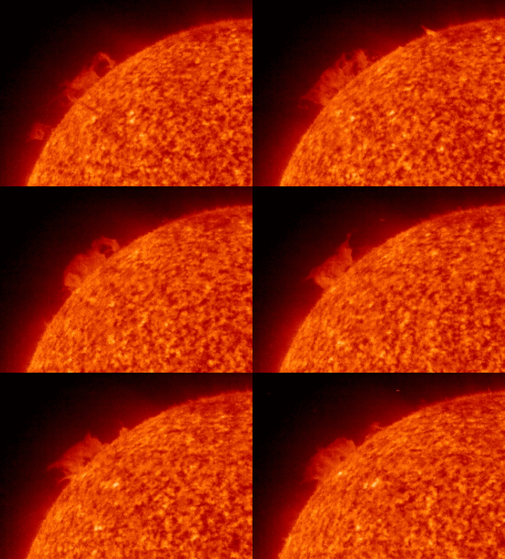
Here's a real "dousey," as Ned Ryerson would say in Ground Hog Day. If you go to Spaceweather, you can read all about it. Meanwhile, I figured I'd post it here because it's so danged beautiful and mysterious and even a wee bit Gothic.
When it rains it pours

Above is the precip prediction mosaic for the lower 48. Pretty danged impressive precip figures progged out on the coast and up in the Idaho Panhandle. If these figs come to pass, somebody, someplace is somehow gonna be in a world o' hurt! (NOTE: We liked this graphic so much we found its source and made it a permanent part of our links at left.)
 When these big Pacific storms roll ashore and dumpall their water on the windward side of the Cascade Range, it always reminds me of a huge bomber hugging the deck and speeding toward its destructive destiny. These types of storms are so awesome and magnificent. I try to imagine the sheer weight of the water in the sky. All weather is wonderful but winter weather is even more so!
December 25, 2008
Snow snippets
(Edited 27DEC) We roamed El Net on Christmas looking for "snow snippets."
We continue to look for little gems. on 27DEC we found this in a editorial by the Portland Oregonian newspaper: "...a storm rated as the region's worst in 40 years." The Portland NWS verifies this here.
The snippets below were the ones found on Christmas Day.
Here's a few we found in one single AP article:
"A blizzard warning for the San Juan mountains in southwest Colorado warned that as much as 3 feet of snow was possible."
"About 2 feet of snow fell overnight in the mountains around Lake Tahoe, bringing totals at some resorts in the past two weeks to 10 feet."
"Up to 18 inches of snow was possible in the Cascades; in the eastern half of the state Spokane, expected 5 to 7 inches of new snow atop a heavy layer that accumulated during weeks of storms."
From a a different source comes this gem:
"In Canada, meteorologists are predicting the first coast-to-coast white Christmas since 1971."
From Wisconsin media we learn:
"Wednesday's 2.9 inches of snow in Madison pushed the December total to 36.1 inches, breaking the December record of 35 inches set in 2000, the National Weather Service reported. The normal December total is 9.1 inches and last December's total was 26.4.
It also pushed the calendar year 2008 total to 106.8 inches, far above the old record of 82.6 inches in 1994.
The lone remaining record standing is the all-time monthly total of 37 inches set in February 1994.
And this from an agricultural publication:
"The snow depth at Claifornia's Big Bear Lake climbed to 54 inches. Big Bear Lake's greatest snow depth on record was 58 inches on February 3, 1979."
We continue to look for little gems. on 27DEC we found this in a editorial by the Portland Oregonian newspaper: "...a storm rated as the region's worst in 40 years." The Portland NWS verifies this here.
The snippets below were the ones found on Christmas Day.
Here's a few we found in one single AP article:
"A blizzard warning for the San Juan mountains in southwest Colorado warned that as much as 3 feet of snow was possible."
"About 2 feet of snow fell overnight in the mountains around Lake Tahoe, bringing totals at some resorts in the past two weeks to 10 feet."
"Up to 18 inches of snow was possible in the Cascades; in the eastern half of the state Spokane, expected 5 to 7 inches of new snow atop a heavy layer that accumulated during weeks of storms."
From a a different source comes this gem:
"In Canada, meteorologists are predicting the first coast-to-coast white Christmas since 1971."
From Wisconsin media we learn:
"Wednesday's 2.9 inches of snow in Madison pushed the December total to 36.1 inches, breaking the December record of 35 inches set in 2000, the National Weather Service reported. The normal December total is 9.1 inches and last December's total was 26.4.
It also pushed the calendar year 2008 total to 106.8 inches, far above the old record of 82.6 inches in 1994.
The lone remaining record standing is the all-time monthly total of 37 inches set in February 1994.
And this from an agricultural publication:
"The snow depth at Claifornia's Big Bear Lake climbed to 54 inches. Big Bear Lake's greatest snow depth on record was 58 inches on February 3, 1979."
Red is a rare color

Yep, red's a rare color on these here maps. Red is the appropriate color for a blizzard warning. You might call it Code Red. All kidding aside, red is not a good color to see on a NWS warning map. It means people who are out in those conditions are facing very dire straits. Our prayers go out to those who are traveling Code Red areas on Christmas Day. (Click the little picture to see the full size version.)
Frisky forecasters
Once in awhile the normally dour NWS forecasters kick up their heels and add itty-bitty little personal comments in the AFD's. ANd so it is today--Christmas Day--that the Pokie-Mon (That's our private term for Pocatello NWS Forecasters) added the nifty little header the 3 am AFD:
WELCOME TO THE CHRISTMAS 2008 WINTER STORM FOR EASTERN IDAHO. A VERY COMPLEX AND DANGEROUS SITUATION HAS DEVELOPED ACROSS SOUTHERN AREAS. CURRENT SATELLITE AND RADAR SHOW PLENTY OF SNOW ACROSS THE AREA. ADDRESSING WIND AND HEAVY SNOW FIRST...BLIZZARD CONDITIONS HAVE DEVELOPED ACROSS PORTIONS OF THE MAGIC VALLEY AND SNAKE RIVER PLAIN. WIND GUSTS OF 50 TO 60 MPH ARE COMMON AT 245 AM IN FROM AROUND FT HALL TO POCATELLO TO WEST TO BURLEY AND ACROSS THE SOUTHERN HIGHLANDS. THE STRONGER WINDS ARE NOW BEGINNING TO SPREAD FARTHER NORTH INTO THE SNAKE PLAIN. THESE AREAS WILL CONTINUE TO SEE VERY STRONG WINDS UNTIL LATER IN THE AFTERNOON AS THE FRONT PASSES THROUGH THE AREA. FOR THE REST OF EASTERN IDAHO...SNOW AND GUSTY WINDS WILL CREATE HAZARDOUS DRIVING CONDITIONS AS WELL THROUGH TONIGHT. SNOWFALL TOTALS THROUGH 5PM TODAY ARE GENERALLY 5 TO 10 INCHES WITH HIGHER AMOUNTS IN THE SNAKE RIVER PLAIN. FOR THE CENTRAL MOUNTAINS ARE 4 TO 8 INCHES WITH UP TO 10 INCHES ON THE PEAKS IN THE LOST RIVER/PAHSIMEROI REGION...THE REST OF THAT AREA WILL SEE 9 TO 12 INCHES IN THE VALLEYS WITH UP TO 2 FEET IN THE SAWTOOTHS. OUR OTHER MOUNTAINOUS AREAS WILL SEE 8 TO 13 INCHES IN THE VALLEYS WITH UP TO 2 FEET IN THE IDAHO WASATCH. THE EXCEPTION WILL BE THE SOUTH CENTRAL HIGHLANDS WHERE 5 TO 10 INCHES TOTAL IS FORECAST.
WELCOME TO THE CHRISTMAS 2008 WINTER STORM FOR EASTERN IDAHO. A VERY COMPLEX AND DANGEROUS SITUATION HAS DEVELOPED ACROSS SOUTHERN AREAS. CURRENT SATELLITE AND RADAR SHOW PLENTY OF SNOW ACROSS THE AREA. ADDRESSING WIND AND HEAVY SNOW FIRST...BLIZZARD CONDITIONS HAVE DEVELOPED ACROSS PORTIONS OF THE MAGIC VALLEY AND SNAKE RIVER PLAIN. WIND GUSTS OF 50 TO 60 MPH ARE COMMON AT 245 AM IN FROM AROUND FT HALL TO POCATELLO TO WEST TO BURLEY AND ACROSS THE SOUTHERN HIGHLANDS. THE STRONGER WINDS ARE NOW BEGINNING TO SPREAD FARTHER NORTH INTO THE SNAKE PLAIN. THESE AREAS WILL CONTINUE TO SEE VERY STRONG WINDS UNTIL LATER IN THE AFTERNOON AS THE FRONT PASSES THROUGH THE AREA. FOR THE REST OF EASTERN IDAHO...SNOW AND GUSTY WINDS WILL CREATE HAZARDOUS DRIVING CONDITIONS AS WELL THROUGH TONIGHT. SNOWFALL TOTALS THROUGH 5PM TODAY ARE GENERALLY 5 TO 10 INCHES WITH HIGHER AMOUNTS IN THE SNAKE RIVER PLAIN. FOR THE CENTRAL MOUNTAINS ARE 4 TO 8 INCHES WITH UP TO 10 INCHES ON THE PEAKS IN THE LOST RIVER/PAHSIMEROI REGION...THE REST OF THAT AREA WILL SEE 9 TO 12 INCHES IN THE VALLEYS WITH UP TO 2 FEET IN THE SAWTOOTHS. OUR OTHER MOUNTAINOUS AREAS WILL SEE 8 TO 13 INCHES IN THE VALLEYS WITH UP TO 2 FEET IN THE IDAHO WASATCH. THE EXCEPTION WILL BE THE SOUTH CENTRAL HIGHLANDS WHERE 5 TO 10 INCHES TOTAL IS FORECAST.
Washington Emergency
On Christmas Eve, Washington State Gov. Chris Gregoire proclaimed a state of emergency due to the weather and storms across the state.
"Snowfall has reached record or near-record level in 30 of the state's 39 counties," Gregoire said in a statement. "Many communities, especially in eastern Washington, are expecting as much as a foot or more of additional snow this holiday weekend.
"This proclamation will enable the state to respond quickly to local requests for emergency support and assistance arising from these new storms."
Things could go from real bad to really terrible for Washington State. Oregon is looking at 2-3 inches of rainfall over the weekend--with the snow level ABOVE the pass levels! WOW--that could cause real headline floods throughout the Oregon. I'd reckon Washington could be in line for some of the same. OUCH!
Here's The Portland Christmas discussion:
WHAT IS BECOMING MORE CLEAR HOWEVER IS THAT THE PRECIPITATION AMOUNTS THE COAST RANGE AND CASCADES ARE LIKELY TO RECEIVE WILL BE RATHER HIGH. MODELS SHOW EXTENDED PERIODS OF 20-40KT OF WESTERLY MID LEVEL FLOW FROM SATURDAY AFTERNOON THROUGH TUESDAY. RIGHTFULLY SO...MODELS SHOW UPWARDS OF 2 TO 3 INCHES OF QPF DURING THIS TIME PERIOD. THE RAIN/SNOW LINE SHOULD BE ABOVE PASS LEVELS THIS WEEKEND AND EARLY NEXT WEEK...SO LOW LEVEL SNOW WILL NOT BE AN ISSUE. HOWEVER...THE SKI RESORTS COULD END UP WITH A SIGNIFICANT AMOUNT OF SNOW...POSSIBLY 2-3 FEET.
"Snowfall has reached record or near-record level in 30 of the state's 39 counties," Gregoire said in a statement. "Many communities, especially in eastern Washington, are expecting as much as a foot or more of additional snow this holiday weekend.
"This proclamation will enable the state to respond quickly to local requests for emergency support and assistance arising from these new storms."
Things could go from real bad to really terrible for Washington State. Oregon is looking at 2-3 inches of rainfall over the weekend--with the snow level ABOVE the pass levels! WOW--that could cause real headline floods throughout the Oregon. I'd reckon Washington could be in line for some of the same. OUCH!
Here's The Portland Christmas discussion:
WHAT IS BECOMING MORE CLEAR HOWEVER IS THAT THE PRECIPITATION AMOUNTS THE COAST RANGE AND CASCADES ARE LIKELY TO RECEIVE WILL BE RATHER HIGH. MODELS SHOW EXTENDED PERIODS OF 20-40KT OF WESTERLY MID LEVEL FLOW FROM SATURDAY AFTERNOON THROUGH TUESDAY. RIGHTFULLY SO...MODELS SHOW UPWARDS OF 2 TO 3 INCHES OF QPF DURING THIS TIME PERIOD. THE RAIN/SNOW LINE SHOULD BE ABOVE PASS LEVELS THIS WEEKEND AND EARLY NEXT WEEK...SO LOW LEVEL SNOW WILL NOT BE AN ISSUE. HOWEVER...THE SKI RESORTS COULD END UP WITH A SIGNIFICANT AMOUNT OF SNOW...POSSIBLY 2-3 FEET.
December 24, 2008
Moderately major

Here's the Western USA NWS mosaic of various warnings, watches and what not. Most of the Pacific NW and what some people call tine "Inland Northwest" is blanketed by winter storm warnings and watches. Snow is progged to start today over most of this area and then gain momentum during the night and on Christmas Day. Idaho Falls is progged to get anywhere from 4-8 inches total during that 36-hour time frame.
Meanwhile, there's some ominous chunks of water vapor gathering steam out in the Pacific. They are moving this way pretty fast, too. It's a long read but check out the 3 am Portland NWS Discussion for 24DEC.
.LONG TERM...NO CHANGES. PREVIOUS DISCUSSION FOLLOWS...AVAILABLE GUIDANCE ALL SEEMS TO POINT TO A VERY WET AND ACTIVE EXTENDED FORECAST. STRATIFORM RAIN WILL SPREAD ACROSS THE AREA ON FRIDAY AFTERNOON AND EVENING AS A PACIFIC SYSTEM MAKES LANDFALL NORTH OF VANCOUVER ISLAND. THIS SYSTEM OPENS UP ZONAL FLOW THAT STRETCHES INTO THE PACIFIC NORTHWEST FROM WELL PAST THE ALEUTIAN CHAIN. WITH SUCH A FAST FLOW ACROSS THE PACIFIC...AND SEVERAL EMBEDDED SYSTEMS FORECAST TO MOVE THROUGH THE DISTRICT FROM SATURDAY ONWARD...KEPT LIKELY POPS IN THE LOWLANDS AND CATEGORICAL POPS ALONG THE COAST AND COAST RANGE AS WELL AS IN THE CASCADES FOR THE ENTIRE EXTENDED TIME FRAME. ADDITIONALLY...WESTERLY H85 FLOW OF +30KT IS FORECAST FROM SATURDAY MORNING ONWARD...WITH FREEZING LEVELS BETWEEN 3500-5000 FEET. WITH SUCH FAVORABLE OROGRAPHIC FLOW AND MODEL QPF VALUES OF 2-3 INCHES DURING THIS TIME PERIOD...A SIGNIFICANT AND PROLONGED PERIOD OF MOUNTAIN SNOW SEEMS LIKELY...LIKELY IN EXCESS OF 3 FT IF FREEZING LEVELS STAY AROUND OR BELOW PASS LEVELS. DALTON
December 23, 2008
White Christmas

Ain't that a purty Pacific picture? The curly-cues that have been forming out in the Deep Pacific this winter have been downright artistic! The little wad of water vapor you see in the Pac NW is due to arrive in SE Idaho on Christmas, virtually guaranteeing a White Christmas. It won't produce much accumulation--just a lot of big, fat flakes in the cold, crisp air.
However, Loyal Readers, we wish to call your attention to that huge chuck of water vapor visible on the far left of the above picture. (roughly 190W 45N) Now THAT is something! If that blob can retain its integrity by the time it washes ashore over here, may have to call Houston and report that we have a problem.
Well, I promise to tidy up this blog on Christmas Eve--I've let it slide for awhile. We've had some decent snow in Idaho Falls (KIDA). I've been walking to work each day because it's too messy to drive. As Tim McGraw would say, "I like it, I love it, and I want some more of it!"
December 20, 2008
Aurora

Do I overuse the word WOW? Probably so. Anyway, there's this great show of 10 slides of the Aurora. You've really got to check it out. WOW! Click here and enjoy. Cheers, j
Forecasters: Storm to be 'life-threatening'

The latest out of the Seattle media is that the impending storm is "life threatening." Them's pretty strong words. Click here to read their spin. Click the small graphic above to see a larger version. We've been reading a lot about this event all day. It's pretty substantial, that's for sure. The jetstream is as distended as I've seen it in a long time. Meanwhile, there's a really solid tropical moisture feed on tap--in fact they are calling this a "major extratropical storm." It sure looks promising. As I write this the Olympic Peninsular is under a blizzard warning. Go to the Seattle NWS and click on their Powerpoint presentation. If you have Flash player, the show has audio, too. Seattle is really hunkering down.
Meanwhile Up in the Idaho Panhandle, this last round smacked hard:
Wednesday and Thursday dropped a total of 33 inches of snow on Coeur d'Alene, breaking a two-day record of 20 inches set in 1922.
The storm also broke a record for the most snow during a 24-hour period in Coeur d'Alene as 25 inches fell between 8 a.m. Wednesday and 8 a.m. Thursday. The old 24-hour record was 16 inches in 1955. Records have been kept since 1895.
December 19, 2008
Some solstice, eh?

WOW--how 'bout that photo of Mt. Rainier during the onset of this last awesome episode?
The Intermountain West pretty well got stuccoed in the past few days. Code Red in Spokane with over 2 feet on the ground. And even Vegas got paralyzed, albeit with only 3.6 inches of white stuff. Key SNOTELs in Arizona are showing 40+ inches. The headwaters of the Virgin above Utah's Zion is at 40 inches. Real good looking snowpack numbers for the Winter Solstice. We should enter the New Year with a snowpack at or above average. Why? Well, here are some Friday morning snippets from various NWS Offices--you be the judge:
(POCATELLO)A POTENT LOW IS EXPECTED TO MOVE INLAND FROM THE NORTHERN PACIFIC AND SPREAD MOISTURE OVER THE REGION BEGINNING SUNDAY NIGHT. SNOW IS EXPECTED THROUGHOUT THE FORECAST AREA INTO MONDAY BEFORE THE SYSTEM WEAKENS AND MOVES INTO THE GREAT PLAINS.EXPECT SIGNIFICANT SNOW AMOUNTS WITH THIS SYSTEM ESPECIALLY IN THE HIGHER ELEVATIONS.
(MISSOULA)SUNDAY THROUGH TUESDAY...A MOIST PACIFIC SYSTEM WILL MOVE INTO THE NORTHERN ROCKIES ON SUNDAY BRINGING THE POTENTIAL FOR WIDESPREAD SNOWFALL TO THE AREA. WEDNESDAY THROUGH CHRISTMAS DAY...A STRONGER PACIFIC SYSTEM WILL DROP DOWN FROM THE GULF OF ALASKA EARLY NEXT WEEK AND BEGIN TO IMPACT THE NORTHERN ROCKIES BY CHRISTMAS EVE. THIS SYSTEM WILL BRING EVEN MORE PACIFIC MOISTURE TO THE AREA THAN THE PREVIOUS ONE ANOTHER ROUND OF WIDESPREAD SNOW THROUGH CHRISTMAS DAY.
(ELKO)LONG TERM...SUNDAY NIGHT THROUGH THURSDAY. OVERALL...THE EXTENDED REMAINS QUITE STORMY. THE PERIOD STARTS WITH A POTENT CLOSED LOW DUMB-BELLING SOUTHEASTWARD FROM THE NORTHEAST PACIFIC SUNDAY NIGHT AND MONDAY. LOOKS LIKE A GOOD MOISTURE FEED AHEAD OF THIS SYSTEM SO KEPT HIGH POPS AND SNOWFALL TOTALS. STILL LOOKS LIKE THIS COULD BE THE FIRST WARNING EVENT OF THE SEASON FOR NORTHEASTERN NEVADA SNOWFALL-WISE.
(Portland) ATTENTION THEN TURNS TO THE NEXT RATHER STRONG PACIFIC FRONTAL SYSTEM THAT WILL APPROACH SATURDAY AFTERNOON AND MOVE THROUGH OUR FORECAST AREA SATURDAY NIGHT AND SUNDAY. THIS COULD BE THE MOST SIGNIFICANT STORM SINCE EARLY JANUARY 2004.
(Seattle)THIS WILL BE ANOTHER NIGHTMARE IN TRYING TO TARGET SNOW AMOUNTS. KITSAP/HOOD CANAL ESPECIALLY SHOULD GET HAMMERED...COULD SEE 1.5 FEET OF SNOW IN SPOTS...MAYBE MORE.
(Boise)...AGREE ON A BREAK THROUGH OF THE WESTERLIES ACROSS THE PACIFIC INTO THE INTERMOUNTAIN AREA WITH AMPLE OVER-RUNNING MOISTURE IN THE SATURDAY NIGHT TO SUNDAY NIGHT TIME FRAME. IT APPEARS THAT THE BULK OF THE PRECIPITATION WOULD FALL SUNDAY WITH VALLEY AND MOUNTAIN AREAS PICKING UP CONSIDERABLE AMOUNTS OF WET SNOW.
(Note--Photo above by Tim Thompson, obtained from KOMO News in Seattle. For personal use only.)
December 16, 2008
Some solar news

(Edited 4 times--Last on 24DEC @ 7 am) We last edited this post on December 17--a week ago. That was a couple of days after a purported CME took place on the back side of the sun. A CME is a Coronal Mass Ejection. There was some excited chatter about it on Spaceweather.com and then the whole topic totally disappeared. Now there's new chatter about something soon to rotate into view, probably 26DEC. It sure looks to me like it's in the same location as the purported CME. Anywho, it's going to be interesting to see exactly what it really is and who it affects solar emissions. You can read all about it on Spaceweather, linked at left.
Play calling genius!

Our favorite team, The Pacific Precipitators, generally crushes its perennial opponent, The Lower 48. The Precipitator Coach has a tremendous playbook, especially of trick plays. The Precipitator offense loves to take a pigskin filled with water across the Lower 48 line and stuff it in the endzone. This is Old School football, and it's measured in inches and feet, not yards. A first down is one foot. The Precipitators love to rack up first downs as they push their wad o' water downstream, er, downfield. The play illustrated above is one of the classics called the Pineapple Pipeline. The Precipitator QB takes the pigskin in a shotgun snap and scoots through a vicious block by his left tackle and guard. Meanwhile, the right flanker runs wide left. As the Lower 48 backfield closes in, the QB pitched off a lateral to teh flanker who then heads downfield unmolested. It's quite the play and we're about to see yet another rendition of this time-honored classic in the next few days.
Meanwhile, Olde Airy Zonie finally finally got a gobsmack from the Precipitators.
NEW SNOWFALL AMOUNTS REPORTED AS OF 530 AM MST INCLUDE...
FLAGSTAFF AIRPORT ............ 8.2 INCHES.
BELLEMONT .................... 6.4 INCHES.
MUNDS PARK ................... 12 INCHES.
HART PRAIRIE .................. 9 INCHES.
Stay tuned, sportsfans, we ain't seen the best yet!
December 15, 2008
Is it real or "Snopocalypse"
Arizona is progged to get the next slap in the face from this multi-faceted storm. Check this morning's Flagstaff warning:
SNOWFALL ACCUMULATIONS OF 12 TO 25 INCHES ARE EXPECTED BY LATE TUESDAY ACROSS THE KAIBAB PLATEAU AND THE SOUTH FACING SLOPES OF THE MOGOLLON RIM. EIGHT TO 16 INCHES ARE EXPECTED OVER THE YAVAPAI COUNTY MOUNTAINS...AND 6 TO 12 INCHES OVER BLACK MESA..DEFIANCE PLATEAU..CHUSKA MOUNTAINS..AND THE WHITE MOUNTAINS.
Lately, the weather forecasting industry has been crying wolf a tad too often. A blogger in Seattle coined this phenomena "snopocalypose." You can read her comments here.
One thing's fairly certain--federal snow measuring stations don't lie. They may malfunction but they don't lie or exaggerate. Use the SNOTEL link at left. Click on the state of your choice. Then click on the map's remote sensing site of your choice. Next, click on Snow Depth as reported hourly for the past 7 days. Scroll to the bottom of the data for the latest readings.
SNOWFALL ACCUMULATIONS OF 12 TO 25 INCHES ARE EXPECTED BY LATE TUESDAY ACROSS THE KAIBAB PLATEAU AND THE SOUTH FACING SLOPES OF THE MOGOLLON RIM. EIGHT TO 16 INCHES ARE EXPECTED OVER THE YAVAPAI COUNTY MOUNTAINS...AND 6 TO 12 INCHES OVER BLACK MESA..DEFIANCE PLATEAU..CHUSKA MOUNTAINS..AND THE WHITE MOUNTAINS.
Lately, the weather forecasting industry has been crying wolf a tad too often. A blogger in Seattle coined this phenomena "snopocalypose." You can read her comments here.
One thing's fairly certain--federal snow measuring stations don't lie. They may malfunction but they don't lie or exaggerate. Use the SNOTEL link at left. Click on the state of your choice. Then click on the map's remote sensing site of your choice. Next, click on Snow Depth as reported hourly for the past 7 days. Scroll to the bottom of the data for the latest readings.
December 13, 2008
Winter's Wrath
Hum...well, Class, this one definitely is a real "hum dinger." A huge chunk of the northern plains is in a blizzard warning. Winter storms warnings pockmark the Intermountain West. Meanwhile, the Oregon Coast is still getting slammed by 20-25 waves with some exceeding 30 feet. I'm sure you've seen the havoc in the Northeast with over a million people without power. Yeah, I reckon this is going to be an epic winter, afterall. I kinda gave up hope on it for awhile but now it's back with a vengeance. Here in Idaho Falls, the temps were hanging in the upper 20's until the front passed and they nosedived 17-20 degrees in one hour. A whiteout snowfall almost brought traffic to a standstill. Temps are stable right now in single digits and the snow has slacked off. But, yeah, this is actually "the real deal." Click the "Climate Predict Ctr." at left. You will see the next couple of weeks are progged to be "above normal" precip! YAHOO!
December 12, 2008
Major Winter Storm
We are finally on tap for a genuine winter storm--one that slaps the coast hard and then leaps tall mountains to wreck havoc throughout the interior West. This is a real deal. Every mountain range from the Cascades to the Wasatch is going to get 1-2 feet of snow. Snow could even fall on the Washington-Oregon beaches. Every valley north of Arizona will see some snow, too. Winds will be howling and peak gusts upwards of 50 mph are probable. Meanwhile, a huge tsunami of arctic air will inundate several states, dropping temps upwards of 20 degrees and creating windchills possibly as low as -15°F.
As we roam the various NWS offices reading their Area Forecast Discussions, the enormity of this event grows. Each NWS office tends to look at its own little world.
When taken as a whole, the chatter about this storm is ominous. Salt Lake City NWS has produced by far the best synopsis of this upcoming storm. Your will need Adobe Flash player to see their briefing. It's awesome! Click here to check it out.
As of mid-morning Friday, Idaho Falls is still bathed in bright sun. Our windsock hangs limp for one final day in the proverbial calm before the storm. It's another peaceful day here on the Snake River Plain.
We are changing our blog plan. As a storm evolves, we may or may not make new posts. We are more inclined to delete the top post and make a new one in its place. You may have noticed we've already deleted two post written Thursday. They have no relevance as the storm is now certain to be a big one.
One last note to one loyal reader(s), take a look at the jetstream and watch it evolve. Very impressive!
Buckle up for this one, puppies, it's gonna rock yer doghouse!
As we roam the various NWS offices reading their Area Forecast Discussions, the enormity of this event grows. Each NWS office tends to look at its own little world.
When taken as a whole, the chatter about this storm is ominous. Salt Lake City NWS has produced by far the best synopsis of this upcoming storm. Your will need Adobe Flash player to see their briefing. It's awesome! Click here to check it out.
As of mid-morning Friday, Idaho Falls is still bathed in bright sun. Our windsock hangs limp for one final day in the proverbial calm before the storm. It's another peaceful day here on the Snake River Plain.
We are changing our blog plan. As a storm evolves, we may or may not make new posts. We are more inclined to delete the top post and make a new one in its place. You may have noticed we've already deleted two post written Thursday. They have no relevance as the storm is now certain to be a big one.
One last note to one loyal reader(s), take a look at the jetstream and watch it evolve. Very impressive!
Buckle up for this one, puppies, it's gonna rock yer doghouse!
Subscribe to:
Posts (Atom)