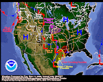
If a watershed could smile, we suspect the Upper Snake is smiling today. The Camp Springs, Maryland, weather wonks have this to say: "3-DAY SNOWFALL TOTALS OF 2-3 FEET ARE PROJECTED ACROSS THE CASCADES OF WASHINGTON...MOST OF NORTHERN IDAHO...EXTREME NORTHWEST MONTANA AND THE TETONS..." Pocatello NWS 2 pn 27DEC AFD says "SEEMINGLY ENDLESS STREAM OF PACIFIC MOISTURE IS POURING INTO THE REGION." The QPF graphs shows a direct hit on Y-stone and the Tetons. This is real good news for Tater Nation as the NRCS says the Upper Snake only needs a 90% snowpack to have adequate irrigation for the 2009 growing season. If the latest forecast comes true, Tater Nation's ruler King Tot will throw a New Year's party!

Meanwhile, check the 27DEC warning mosaic in the Midwest. It's hard to remember a weirder grouping of warnings all bunched together. You've got a tornado watch, a flash flood warning, an ice storm warning and even a red flag warning way down south. What an eclectic mix of watches and warnings!
Meanwhile, parts of the PAC NW coast are indeed getting some decent rainfall. NW Oregon is under a flood warning so we will probably have some media coverage of the results here pretty soon. Stay tuned.


No comments:
Post a Comment