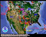
We are finally on tap for a genuine winter storm--one that slaps the coast hard and then leaps tall mountains to wreck havoc throughout the interior West. This is a real deal. Every mountain range from the Cascades to the Wasatch is going to get 1-2 feet of snow. Snow could even fall on the Washington-Oregon beaches. Every valley north of Arizona will see some snow, too. Winds will be howling and peak gusts upwards of 50 mph are probable. Meanwhile, a huge tsunami of arctic air will inundate several states, dropping temps upwards of 20 degrees and creating windchills possibly as low as -15°F.
As we roam the various NWS offices reading their Area Forecast Discussions, the enormity of this event grows. Each NWS office tends to look at its own little world.
When taken as a whole, the chatter about this storm is ominous. Salt Lake City NWS has produced by far the best synopsis of this upcoming storm. Your will need Adobe Flash player to see their briefing. It's awesome! Click here to check it out.
As of mid-morning Friday, Idaho Falls is still bathed in bright sun. Our windsock hangs limp for one final day in the proverbial calm before the storm. It's another peaceful day here on the Snake River Plain.
We are changing our blog plan. As a storm evolves, we may or may not make new posts. We are more inclined to delete the top post and make a new one in its place. You may have noticed we've already deleted two post written Thursday. They have no relevance as the storm is now certain to be a big one.
One last note to one loyal reader(s), take a look at the jetstream and watch it evolve. Very impressive!
Buckle up for this one, puppies, it's gonna rock yer doghouse!
December 12, 2008
Subscribe to:
Post Comments (Atom)


No comments:
Post a Comment